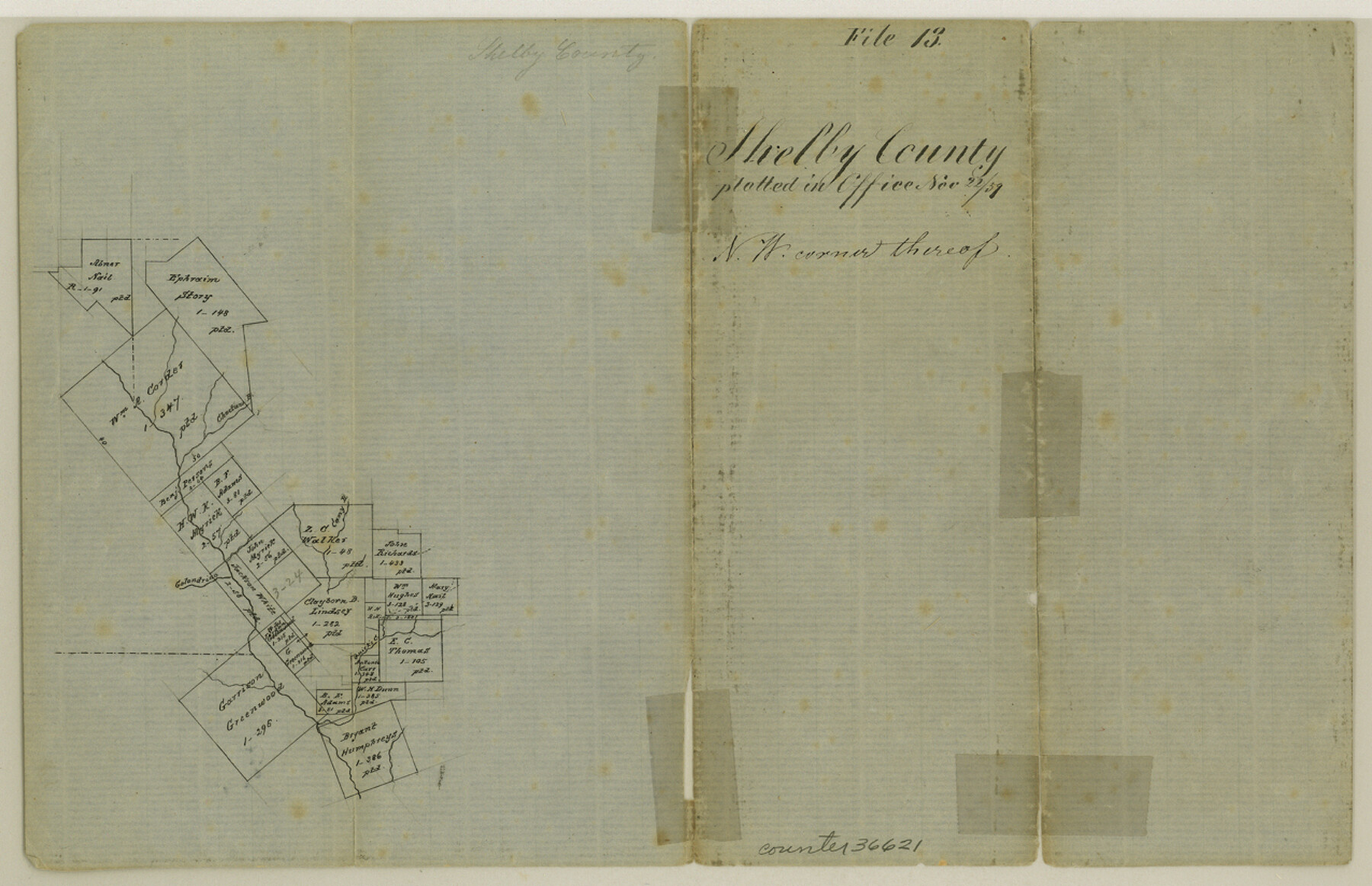
Shelby County Sketch File 13
[Office sketch of surveys in the northwest corner of the county along the boundary line with both Rusk and Nacogdoches Counties]
-
Map/Doc
36621
-
Collection
General Map Collection
-
Object Dates
11/22/1859 (Creation Date)
-
Counties
Shelby Rusk Nacogdoches
-
Subjects
Surveying Sketch File
-
Height x Width
8.2 x 12.8 inches
20.8 x 32.5 cm
-
Medium
paper, manuscript
-
Features
Colondrino Creek
Cany Creek
Quick's Creek
Part of: General Map Collection
Bell County Sketch File 10

Print $4.00
- Digital $50.00
Bell County Sketch File 10
1851
Size 12.7 x 8.4 inches
Map/Doc 14381
Sutton County Working Sketch 55

Print $20.00
- Digital $50.00
Sutton County Working Sketch 55
1957
Size 42.2 x 28.7 inches
Map/Doc 62398
Township 2 South Range 12 West, South Western District, Louisiana

Print $20.00
- Digital $50.00
Township 2 South Range 12 West, South Western District, Louisiana
1884
Size 19.7 x 24.7 inches
Map/Doc 65882
Cameron County Rolled Sketch 25

Print $20.00
- Digital $50.00
Cameron County Rolled Sketch 25
1977
Size 24.8 x 36.5 inches
Map/Doc 5797
Smith County Working Sketch 13

Print $20.00
- Digital $50.00
Smith County Working Sketch 13
1962
Size 36.8 x 27.4 inches
Map/Doc 63898
Angelina County Sketch File 21

Print $6.00
- Digital $50.00
Angelina County Sketch File 21
1883
Size 8.8 x 4.0 inches
Map/Doc 13038
Brewster County Working Sketch 38

Print $20.00
- Digital $50.00
Brewster County Working Sketch 38
1944
Size 36.3 x 28.4 inches
Map/Doc 67572
Frio County Rolled Sketch 9

Print $20.00
- Digital $50.00
Frio County Rolled Sketch 9
1943
Size 35.7 x 32.5 inches
Map/Doc 5919
Map of a part of Fisher and Miller's Colony - Harvey's District

Print $20.00
- Digital $50.00
Map of a part of Fisher and Miller's Colony - Harvey's District
1856
Size 15.2 x 19.8 inches
Map/Doc 1972
[Sketch for Mineral Application 26501 - Sabine River, T. A. Oldhausen]
![2832, [Sketch for Mineral Application 26501 - Sabine River, T. A. Oldhausen], General Map Collection](https://historictexasmaps.com/wmedia_w700/maps/2832.tif.jpg)
Print $20.00
- Digital $50.00
[Sketch for Mineral Application 26501 - Sabine River, T. A. Oldhausen]
1931
Size 24.0 x 36.0 inches
Map/Doc 2832
Glasscock County Working Sketch 10

Print $40.00
- Digital $50.00
Glasscock County Working Sketch 10
1957
Size 77.9 x 37.2 inches
Map/Doc 63183
Flight Mission No. CGI-4N, Frame 181, Cameron County

Print $20.00
- Digital $50.00
Flight Mission No. CGI-4N, Frame 181, Cameron County
1955
Size 18.2 x 22.4 inches
Map/Doc 84684
You may also like
Reeves County Working Sketch 54

Print $20.00
- Digital $50.00
Reeves County Working Sketch 54
1978
Size 36.9 x 35.6 inches
Map/Doc 63497
Potter County Sketch File 6

Print $20.00
- Digital $50.00
Potter County Sketch File 6
1900
Size 34.4 x 29.0 inches
Map/Doc 10575
North Part Brewster Co.

Print $40.00
- Digital $50.00
North Part Brewster Co.
1914
Size 40.1 x 48.6 inches
Map/Doc 66731
Montgomery County Rolled Sketch 36

Print $20.00
- Digital $50.00
Montgomery County Rolled Sketch 36
1956
Size 25.8 x 23.6 inches
Map/Doc 6812
Gregg County Rolled Sketch 12

Print $40.00
- Digital $50.00
Gregg County Rolled Sketch 12
1939
Size 49.5 x 55.5 inches
Map/Doc 9065
San Jacinto Co.

Print $20.00
- Digital $50.00
San Jacinto Co.
1889
Size 46.4 x 37.9 inches
Map/Doc 63016
Mexico or New Spain in which the Motions of Cortes may be traced

Print $20.00
- Digital $50.00
Mexico or New Spain in which the Motions of Cortes may be traced
1795
Size 14.5 x 16.5 inches
Map/Doc 93650
Shelby County Sketch File 4

Print $4.00
- Digital $50.00
Shelby County Sketch File 4
1852
Size 13.1 x 8.2 inches
Map/Doc 36597
Taylor County Working Sketch 17

Print $20.00
- Digital $50.00
Taylor County Working Sketch 17
1982
Size 42.7 x 37.0 inches
Map/Doc 69627
Upshur County Working Sketch 15b

Print $20.00
- Digital $50.00
Upshur County Working Sketch 15b
1996
Size 36.7 x 29.4 inches
Map/Doc 69572
General Highway Map, Kent County, Texas

Print $20.00
General Highway Map, Kent County, Texas
1940
Size 18.4 x 24.9 inches
Map/Doc 79156
Street guide and metropolitan map of New Orleans [Verso]
![94199, Street guide and metropolitan map of New Orleans [Verso], General Map Collection](https://historictexasmaps.com/wmedia_w700/maps/94199.tif.jpg)
Street guide and metropolitan map of New Orleans [Verso]
1963
Size 18.3 x 27.1 inches
Map/Doc 94199