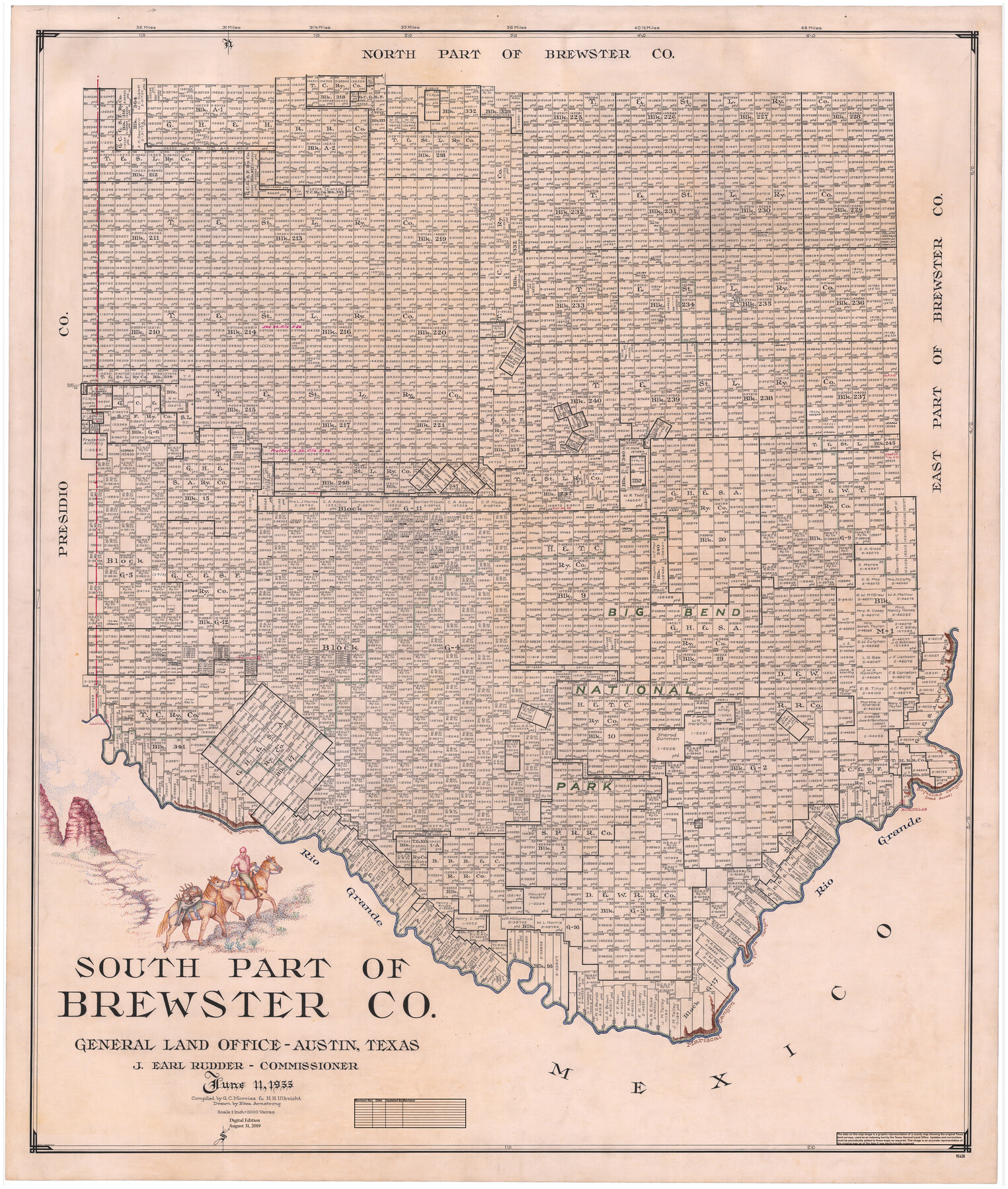
South Part of Brewster Co.
General Land Office Official County Map
-
Map/Doc
95438
-
Collection
General Map Collection
-
Object Dates
2019/8/31 (Revision Date)
1955/6/11 (Creation Date)
-
People and Organizations
Cheyenne Betancourt (Draftsman)
Eltea Armstrong (Draftsman)
G.C. Morriss (Compiler)
Herbert H. Ulbricht (Compiler)
J. Earl Rudder (GLO Commissioner)
-
Counties
Brewster
-
Subjects
County OCM
-
Height x Width
48.9 x 41.4 inches
124.2 x 105.2 cm
-
Medium
digital image
-
Scale
1" = 3000 varas
-
Comments
For east part of Brewster County see 95436 and for north part of Brewster County see 95437.
Related maps
East Part of Brewster Co.

Print $40.00
- Digital $50.00
East Part of Brewster Co.
1952
Size 49.5 x 31.1 inches
Map/Doc 95436
North Part of Brewster Co.

Print $20.00
- Digital $50.00
North Part of Brewster Co.
1956
Size 42.4 x 40.7 inches
Map/Doc 95437
Part of: General Map Collection
San Luis Pass to East Matagorda Bay

Print $20.00
- Digital $50.00
San Luis Pass to East Matagorda Bay
1969
Size 35.1 x 47.0 inches
Map/Doc 69966
Henderson County Working Sketch 6

Print $20.00
- Digital $50.00
Henderson County Working Sketch 6
1919
Size 24.4 x 17.6 inches
Map/Doc 66139
[Sketch for Mineral Application 16696-16697, Pecos River]
![76024, [Sketch for Mineral Application 16696-16697, Pecos River], General Map Collection](https://historictexasmaps.com/wmedia_w700/maps/76024.tif.jpg)
Print $40.00
- Digital $50.00
[Sketch for Mineral Application 16696-16697, Pecos River]
Size 44.0 x 126.6 inches
Map/Doc 76024
Map of Padre Island Showing Location of Zoning Districts

Print $20.00
- Digital $50.00
Map of Padre Island Showing Location of Zoning Districts
1971
Size 18.8 x 26.7 inches
Map/Doc 4809
Henderson County Sketch File 19

Print $4.00
- Digital $50.00
Henderson County Sketch File 19
Size 9.1 x 8.9 inches
Map/Doc 26363
Brewster County Rolled Sketch 60

Print $40.00
- Digital $50.00
Brewster County Rolled Sketch 60
Size 37.1 x 68.9 inches
Map/Doc 8485

Harbor of Brazos Santiago, Texas

Print $20.00
- Digital $50.00
Harbor of Brazos Santiago, Texas
1887
Size 27.2 x 18.4 inches
Map/Doc 72996
Blocks 56 and 57, Townships 1 and 2, resurvey of Texas & Pacific Railway Lands in the eighty mile reservation

Print $20.00
- Digital $50.00
Blocks 56 and 57, Townships 1 and 2, resurvey of Texas & Pacific Railway Lands in the eighty mile reservation
1931
Size 41.4 x 31.4 inches
Map/Doc 2246
Zapata County Rolled Sketch 17A

Print $40.00
- Digital $50.00
Zapata County Rolled Sketch 17A
1953
Size 40.6 x 52.2 inches
Map/Doc 10170
Jim Wells County Working Sketch 3

Print $20.00
- Digital $50.00
Jim Wells County Working Sketch 3
1936
Size 27.7 x 24.5 inches
Map/Doc 66601
Dallam County Sketch File 9

Print $40.00
- Digital $50.00
Dallam County Sketch File 9
1914
Size 9.0 x 7.7 inches
Map/Doc 20357
You may also like
[Texas & Pacific Railway through Callahan County]
![64237, [Texas & Pacific Railway through Callahan County], General Map Collection](https://historictexasmaps.com/wmedia_w700/maps/64237.tif.jpg)
Print $20.00
- Digital $50.00
[Texas & Pacific Railway through Callahan County]
1918
Size 21.8 x 9.2 inches
Map/Doc 64237
Newton County Sketch File 45

Print $12.00
- Digital $50.00
Newton County Sketch File 45
1957
Size 14.1 x 8.7 inches
Map/Doc 32445
Orange County Rolled Sketch 32

Print $20.00
- Digital $50.00
Orange County Rolled Sketch 32
1982
Size 33.6 x 22.5 inches
Map/Doc 7188
Presidio County Working Sketch 9a

Print $20.00
- Digital $50.00
Presidio County Working Sketch 9a
1933
Size 17.3 x 12.2 inches
Map/Doc 71684
Motley County Sketch File B2 (N)

Print $8.00
- Digital $50.00
Motley County Sketch File B2 (N)
Size 8.6 x 6.1 inches
Map/Doc 31970
Camp County Working Sketch 4

Print $20.00
- Digital $50.00
Camp County Working Sketch 4
2003
Size 31.6 x 25.3 inches
Map/Doc 82432
Young County Working Sketch 25

Print $20.00
- Digital $50.00
Young County Working Sketch 25
1982
Size 12.6 x 14.4 inches
Map/Doc 62048
Flight Mission No. CRC-1R, Frame 96, Chambers County

Print $20.00
- Digital $50.00
Flight Mission No. CRC-1R, Frame 96, Chambers County
1956
Size 18.6 x 22.3 inches
Map/Doc 84711
Reagan County Working Sketch 23

Print $40.00
- Digital $50.00
Reagan County Working Sketch 23
1957
Size 25.0 x 60.1 inches
Map/Doc 71865
Official Map of the City of Waxahachie, Texas
.tif.jpg)
Print $20.00
- Digital $50.00
Official Map of the City of Waxahachie, Texas
1922
Size 41.4 x 40.8 inches
Map/Doc 4841
Brewster County Rolled Sketch 121A

Print $40.00
- Digital $50.00
Brewster County Rolled Sketch 121A
1946
Size 37.4 x 54.5 inches
Map/Doc 8518
[Leagues 589-598, 627-630, part of Black Water Pasture]
![90259, [Leagues 589-598, 627-630, part of Black Water Pasture], Twichell Survey Records](https://historictexasmaps.com/wmedia_w700/maps/90259-1.tif.jpg)
Print $3.00
- Digital $50.00
[Leagues 589-598, 627-630, part of Black Water Pasture]
Size 14.5 x 11.5 inches
Map/Doc 90259