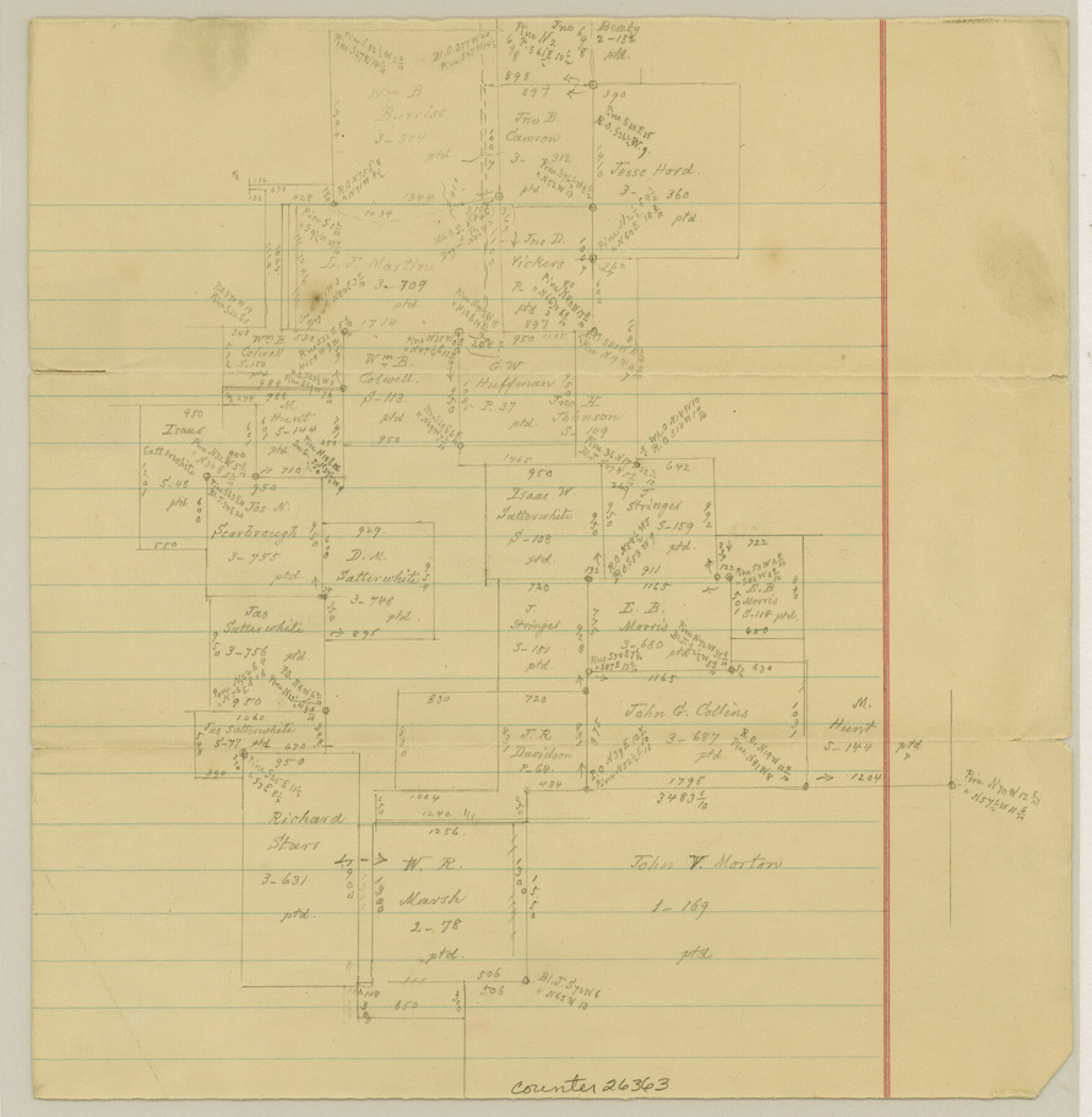
Henderson County Sketch File 19
[Pencil sketch around the Isaac W. Satterwhite survey in the northwest corner of Harrison County]
-
Map/Doc
26363
-
Collection
General Map Collection
-
People and Organizations
Pressler (Surveyor/Engineer)
-
Counties
Harrison
-
Subjects
Surveying Sketch File
-
Height x Width
9.1 x 8.9 inches
23.1 x 22.6 cm
-
Medium
paper, manuscript
Part of: General Map Collection
Harrison County Working Sketch 24

Print $20.00
- Digital $50.00
Harrison County Working Sketch 24
1983
Size 38.0 x 41.3 inches
Map/Doc 66044
Panola County Working Sketch 17

Print $40.00
- Digital $50.00
Panola County Working Sketch 17
1945
Map/Doc 71426
Terrell County Working Sketch 36

Print $20.00
- Digital $50.00
Terrell County Working Sketch 36
1948
Size 26.8 x 39.9 inches
Map/Doc 62129
Morris County Rolled Sketch 2A

Print $20.00
- Digital $50.00
Morris County Rolled Sketch 2A
Size 24.3 x 19.2 inches
Map/Doc 10255
Kimble County Working Sketch 39

Print $20.00
- Digital $50.00
Kimble County Working Sketch 39
1947
Size 30.8 x 23.5 inches
Map/Doc 70107
Denton County Working Sketch 22

Print $20.00
- Digital $50.00
Denton County Working Sketch 22
1983
Size 36.1 x 34.0 inches
Map/Doc 68627
Lipscomb County Sketch File 3

Print $20.00
- Digital $50.00
Lipscomb County Sketch File 3
Size 36.5 x 8.4 inches
Map/Doc 10526
Supplemental Plat of a portion of T. 5S., R. 13W., Indian Mer., Oklahoma

Print $4.00
- Digital $50.00
Supplemental Plat of a portion of T. 5S., R. 13W., Indian Mer., Oklahoma
1922
Size 18.3 x 24.4 inches
Map/Doc 75154
Hale County Boundary File 2

Print $4.00
- Digital $50.00
Hale County Boundary File 2
Size 10.9 x 8.8 inches
Map/Doc 54044
San Patricio County NRC Article 33.136 Sketch 4

Print $3.00
- Digital $50.00
San Patricio County NRC Article 33.136 Sketch 4
Size 11.0 x 17.0 inches
Map/Doc 94695
Montague County Boundary File 2

Print $8.00
- Digital $50.00
Montague County Boundary File 2
Size 8.9 x 6.9 inches
Map/Doc 57406
Comanche County Rolled Sketch 1

Print $20.00
- Digital $50.00
Comanche County Rolled Sketch 1
1985
Size 24.1 x 18.7 inches
Map/Doc 5542
You may also like
Map of Waller County

Print $20.00
- Digital $50.00
Map of Waller County
1897
Size 46.7 x 28.9 inches
Map/Doc 16915
Irion County Working Sketch 4

Print $20.00
- Digital $50.00
Irion County Working Sketch 4
1925
Size 19.4 x 28.1 inches
Map/Doc 66413
Rio Grande, Raymondville Sheet

Print $20.00
- Digital $50.00
Rio Grande, Raymondville Sheet
1937
Size 37.3 x 37.9 inches
Map/Doc 65110
Map of Concho County

Print $20.00
- Digital $50.00
Map of Concho County
1879
Size 23.4 x 18.3 inches
Map/Doc 4523
Maverick County Sketch File 17

Print $20.00
- Digital $50.00
Maverick County Sketch File 17
Size 15.4 x 18.2 inches
Map/Doc 12052
Willie Winn Tract

Print $20.00
- Digital $50.00
Willie Winn Tract
1903
Size 13.2 x 14.1 inches
Map/Doc 92286
Flight Mission No. BRE-1P, Frame 70, Nueces County

Print $20.00
- Digital $50.00
Flight Mission No. BRE-1P, Frame 70, Nueces County
1956
Size 18.3 x 22.1 inches
Map/Doc 86652
A General Map of the Middle British Colonies, in America. containing Virginia, Maryland, the Delaware Counties, Pennsylvania and New Jersey. With the addition of New York and of the Greatest Part of New England

Print $20.00
- Digital $50.00
A General Map of the Middle British Colonies, in America. containing Virginia, Maryland, the Delaware Counties, Pennsylvania and New Jersey. With the addition of New York and of the Greatest Part of New England
1776
Size 21.6 x 27.2 inches
Map/Doc 97402
Archer County Sketch File 8b

Print $42.00
- Digital $50.00
Archer County Sketch File 8b
1890
Map/Doc 88497
Henderson County Rolled Sketch 14

Print $20.00
- Digital $50.00
Henderson County Rolled Sketch 14
2012
Size 19.3 x 32.3 inches
Map/Doc 95715
Carson County Sketch File 7

Print $20.00
- Digital $50.00
Carson County Sketch File 7
Size 26.7 x 15.0 inches
Map/Doc 11056
Rains County Working Sketch 3

Print $20.00
- Digital $50.00
Rains County Working Sketch 3
1918
Size 22.3 x 12.5 inches
Map/Doc 71829