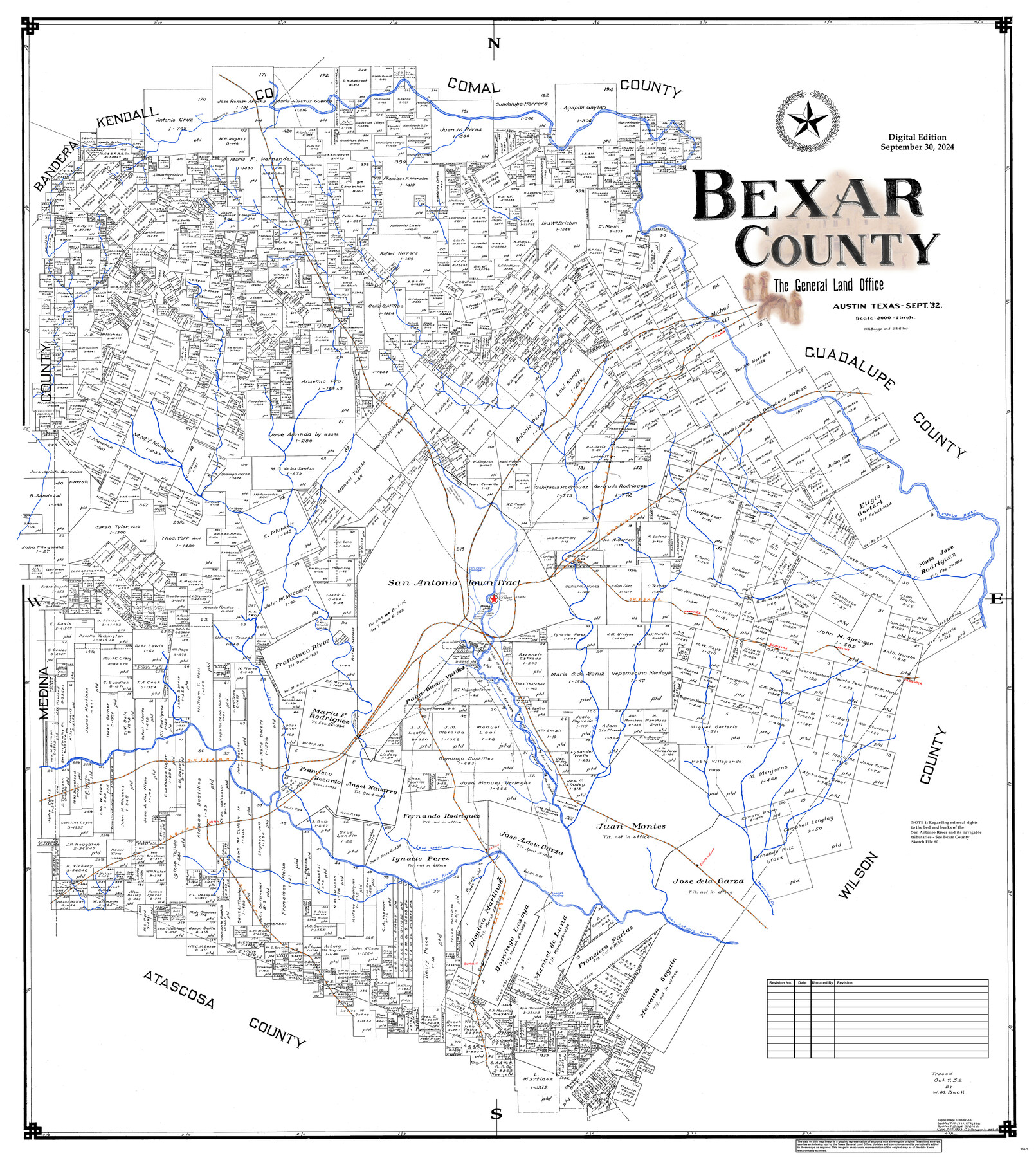
Bexar County
General Land Office Official County Map
- 
                          Map/Doc
95429
 - 
                            Collection
General Map Collection
 - 
                            Object Dates
9/1932 (Creation Date)
9/30/2024 (Revision Date)
 - 
                            People and Organizations
Cheyenne Betancourt (Draftsman)
W.K. Boggs (Draftsman)
J.B. Giles (Draftsman)
 - 
                            Counties
Bexar
 - 
                            Subjects
County OCM
 - 
                            Height x Width
46.7 x 41.1 inches
118.6 x 104.4 cm
 - 
                            Medium
digital image
 - 
                            Scale
1" = 2000 varas
 
Part of: General Map Collection
            Van Zandt County Sketch File 29


                                            Print $4.00                    
                                             -                         Digital $50.00                                    
                Van Zandt County Sketch File 29
1859
Size 8.3 x 6.2 inches
                                Map/Doc 39453
            
            Travis County Appraisal District Plat Map 2_0805


                                            Print $20.00                    
                                             -                         Digital $50.00                                    
                Travis County Appraisal District Plat Map 2_0805
Size 21.4 x 26.4 inches
                                Map/Doc 94231
            
            Flight Mission No. BRE-2P, Frame 48, Nueces County


                                            Print $20.00                    
                                             -                         Digital $50.00                                    
                Flight Mission No. BRE-2P, Frame 48, Nueces County
1956
Size 18.5 x 22.3 inches
                                Map/Doc 86750
            
            Cherokee County Sketch File 4


                                            Print $7.00                    
                                             -                         Digital $50.00                                    
                Cherokee County Sketch File 4
1850
Size 10.3 x 8.2 inches
                                Map/Doc 18117
            
            Nueces County NRC Article 33.136 Sketch 10


                                            Print $36.00                    
                                             -                         Digital $50.00                                    
                Nueces County NRC Article 33.136 Sketch 10
2004
Size 23.9 x 35.9 inches
                                Map/Doc 83526
            
            Mason County Sketch File 3a


                                            Print $4.00                    
                                             -                         Digital $50.00                                    
                Mason County Sketch File 3a
1877
Size 8.3 x 7.9 inches
                                Map/Doc 30682
            
            Sabine Pass and mouth of the River Sabine


                                            Print $20.00                    
                                             -                         Digital $50.00                                    
                Sabine Pass and mouth of the River Sabine
1840
Size 27.0 x 18.3 inches
                                Map/Doc 72726
            
            Flight Mission No. DIX-6P, Frame 124, Aransas County


                                            Print $20.00                    
                                             -                         Digital $50.00                                    
                Flight Mission No. DIX-6P, Frame 124, Aransas County
1956
Size 19.0 x 22.4 inches
                                Map/Doc 83830
            
            Wharton County Sketch File 13


                                            Print $26.00                    
                                             -                         Digital $50.00                                    
                Wharton County Sketch File 13
1894
Size 14.0 x 8.7 inches
                                Map/Doc 39935
            
            Red River County Working Sketch 55


                                            Print $6.00                    
                                             -                         Digital $50.00                                    
                Red River County Working Sketch 55
1971
Size 29.4 x 31.1 inches
                                Map/Doc 72038
            
            Boundary Between the United States & Mexico Agreed upon by the Joint Commission under the Treaty of Guadalupe Hidalgo


                                            Print $20.00                    
                                             -                         Digital $50.00                                    
                Boundary Between the United States & Mexico Agreed upon by the Joint Commission under the Treaty of Guadalupe Hidalgo
1853
Size 18.4 x 26.5 inches
                                Map/Doc 72884
            
            Terrell County Sketch File 32


                                            Print $6.00                    
                                             -                         Digital $50.00                                    
                Terrell County Sketch File 32
1940
Size 11.4 x 8.7 inches
                                Map/Doc 37981
            You may also like
            Reagan County Boundary File 1


                                            Print $8.00                    
                                             -                         Digital $50.00                                    
                Reagan County Boundary File 1
Size 8.8 x 8.9 inches
                                Map/Doc 58151
            
            Enoch's Land Situated in Bailey and Cochran Counties, Texas


                                            Print $20.00                    
                                             -                         Digital $50.00                                    
                Enoch's Land Situated in Bailey and Cochran Counties, Texas
1925
Size 29.1 x 35.7 inches
                                Map/Doc 92515
            
            Red River County Sketch File 11


                                            Print $4.00                    
                                             -                         Digital $50.00                                    
                Red River County Sketch File 11
Size 11.8 x 8.1 inches
                                Map/Doc 35127
            
            [Surveys in Chambers County]


                                            Print $2.00                    
                                             -                         Digital $50.00                                    
                [Surveys in Chambers County]
1847
Size 7.8 x 5.0 inches
                                Map/Doc 249
            
            General Highway Map, Jones County, Texas


                                            Print $20.00                    
                                    
                General Highway Map, Jones County, Texas
1940
Size 18.5 x 24.8 inches
                                Map/Doc 79150
            
            [Map of Jackson County]


                                            Print $20.00                    
                                             -                         Digital $50.00                                    
                [Map of Jackson County]
1836
Size 32.8 x 21.1 inches
                                Map/Doc 78359
            
            Parker County Sketch File 2


                                            Print $4.00                    
                                             -                         Digital $50.00                                    
                Parker County Sketch File 2
1856
Size 12.7 x 8.2 inches
                                Map/Doc 33519
            
            A Chart of the Internal Part of Louisiana


                                            Print $20.00                    
                                             -                         Digital $50.00                                    
                A Chart of the Internal Part of Louisiana
1810
Size 19.0 x 17.3 inches
                                Map/Doc 95155
            
            Atascosa County Boundary File 7


                                            Print $20.00                    
                                             -                         Digital $50.00                                    
                Atascosa County Boundary File 7
Size 8.2 x 10.1 inches
                                Map/Doc 50213
            
            Wichita County Sketch File 14


                                            Print $20.00                    
                                             -                         Digital $50.00                                    
                Wichita County Sketch File 14
1885
Size 17.7 x 17.0 inches
                                Map/Doc 12678
            
            Sherman County


                                            Print $20.00                    
                                             -                         Digital $50.00                                    
                Sherman County
1902
Size 41.0 x 36.7 inches
                                Map/Doc 63035
            
            Map Showing Lands Surveyed for Tom Pinkston, W. D. Twichell and H. Y. Quarles in Stephens County, Texas


                                            Print $20.00                    
                                             -                         Digital $50.00                                    
                Map Showing Lands Surveyed for Tom Pinkston, W. D. Twichell and H. Y. Quarles in Stephens County, Texas
1919
Size 19.7 x 21.2 inches
                                Map/Doc 91892