Terrell County Sketch File 32
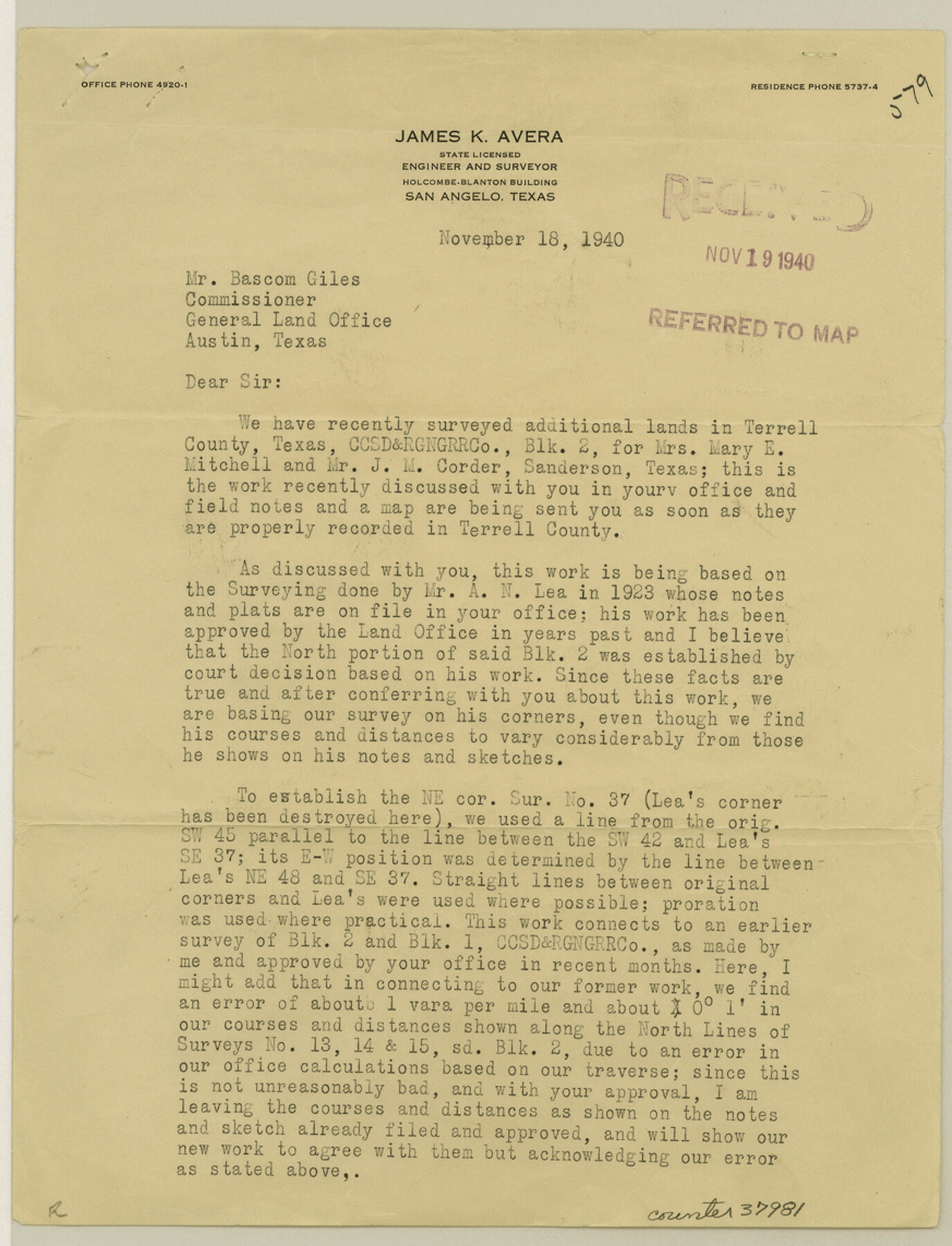
[Report on surveys in Block 2, C. C. S. D. & R. G. N. G.]
-
Map/Doc
37981
-
Collection
General Map Collection
-
Object Dates
11/18/1940 (Creation Date)
11/19/1940 (File Date)
-
People and Organizations
James K. Avera (Surveyor/Engineer)
-
Counties
Terrell
-
Subjects
Surveying Sketch File
-
Height x Width
11.4 x 8.7 inches
29.0 x 22.1 cm
-
Medium
paper, print
-
Comments
See Terrell County Rolled Sketch 38 (7942) for sketch.
Related maps
Terrell County Rolled Sketch 38

Print $20.00
- Digital $50.00
Terrell County Rolled Sketch 38
Size 22.7 x 18.0 inches
Map/Doc 7942
Part of: General Map Collection
Austin County Sketch File 8

Print $40.00
- Digital $50.00
Austin County Sketch File 8
1894
Size 19.3 x 19.9 inches
Map/Doc 10873
Oldham County Sketch File 2

Print $6.00
- Digital $50.00
Oldham County Sketch File 2
1882
Size 12.7 x 8.2 inches
Map/Doc 33225
La Salle County Sketch File 5

Print $2.00
- Digital $50.00
La Salle County Sketch File 5
Size 6.9 x 8.9 inches
Map/Doc 29452
Reeves County Working Sketch 42

Print $20.00
- Digital $50.00
Reeves County Working Sketch 42
1973
Size 46.3 x 31.5 inches
Map/Doc 63485
Hall County Working Sketch 3

Print $20.00
- Digital $50.00
Hall County Working Sketch 3
1916
Size 15.6 x 17.1 inches
Map/Doc 63331
Map of Wise County

Print $20.00
- Digital $50.00
Map of Wise County
1862
Size 23.5 x 19.0 inches
Map/Doc 4162
Childress County

Print $20.00
- Digital $50.00
Childress County
1892
Size 24.7 x 19.6 inches
Map/Doc 3391
Flight Mission No. DIX-5P, Frame 115, Aransas County

Print $20.00
- Digital $50.00
Flight Mission No. DIX-5P, Frame 115, Aransas County
1956
Size 17.5 x 17.6 inches
Map/Doc 83794
Flight Mission No. BRA-7M, Frame 151, Jefferson County

Print $20.00
- Digital $50.00
Flight Mission No. BRA-7M, Frame 151, Jefferson County
1953
Size 18.7 x 22.6 inches
Map/Doc 85545
Harris County Working Sketch 100

Print $20.00
- Digital $50.00
Harris County Working Sketch 100
1979
Size 29.9 x 31.3 inches
Map/Doc 65992
McMullen County Sketch File 12

Print $4.00
- Digital $50.00
McMullen County Sketch File 12
1876
Size 10.9 x 8.3 inches
Map/Doc 31357
Floyd County Sketch File 9

Print $20.00
- Digital $50.00
Floyd County Sketch File 9
1901
Size 22.1 x 15.3 inches
Map/Doc 11484
You may also like
[Report showing connections and corners made on ground in south part of Yoakum County and north part of Gaines County, Texas]

[Report showing connections and corners made on ground in south part of Yoakum County and north part of Gaines County, Texas]
1938
Size 8.1 x 10.9 inches
Map/Doc 93256
Ater Heights Section 44, Block AK

Print $20.00
- Digital $50.00
Ater Heights Section 44, Block AK
1952
Size 11.9 x 18.9 inches
Map/Doc 92347
Pecos County Rolled Sketch 26A

Print $40.00
- Digital $50.00
Pecos County Rolled Sketch 26A
1890
Size 56.4 x 19.5 inches
Map/Doc 9689

Flight Mission No. DCL-6C, Frame 175, Kenedy County

Print $20.00
- Digital $50.00
Flight Mission No. DCL-6C, Frame 175, Kenedy County
1943
Size 18.6 x 22.3 inches
Map/Doc 85987
The Republic County of Montgomery. January 21, 1841

Print $20.00
The Republic County of Montgomery. January 21, 1841
2020
Size 19.9 x 21.7 inches
Map/Doc 96238
Hudspeth County Working Sketch 2

Print $20.00
- Digital $50.00
Hudspeth County Working Sketch 2
1912
Size 22.3 x 17.7 inches
Map/Doc 66283
Cass County Working Sketch 41

Print $20.00
- Digital $50.00
Cass County Working Sketch 41
1985
Size 34.0 x 42.7 inches
Map/Doc 67944
Andrews County Rolled Sketch 26

Print $40.00
- Digital $50.00
Andrews County Rolled Sketch 26
1948
Size 78.3 x 13.2 inches
Map/Doc 8398
Fisher County Sketch File 10

Print $20.00
- Digital $50.00
Fisher County Sketch File 10
Size 9.7 x 37.0 inches
Map/Doc 11477
Reagan County Rolled Sketch 19

Print $20.00
- Digital $50.00
Reagan County Rolled Sketch 19
1939
Size 24.0 x 20.5 inches
Map/Doc 7445
Hill County Boundary File 45b

Print $60.00
- Digital $50.00
Hill County Boundary File 45b
Size 7.8 x 3.7 inches
Map/Doc 54772