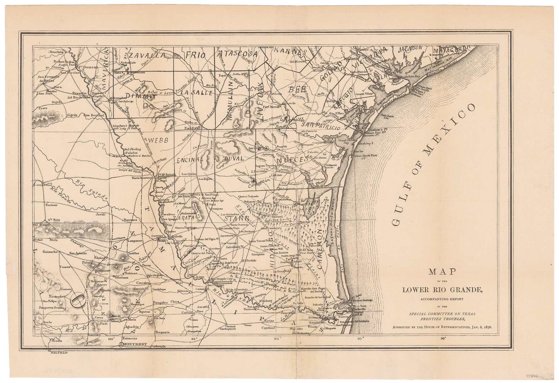
Map of the Lower Rio Grande, accompanying report of the special committee on Texas frontier troubles, appointed by the House of Representatives, Jan. 6, 1876
-
Map/Doc
95406
-
Collection
General Map Collection
-
Object Dates
1876 (Publication Date)
-
Subjects
State of Texas Texas Boundaries
-
Height x Width
12.1 x 17.6 inches
30.7 x 44.7 cm
-
Medium
paper, etching/engraving/lithograph
Part of: General Map Collection


Flight Mission No. DQN-2K, Frame 122, Calhoun County

Print $4.00
- Digital $50.00
Flight Mission No. DQN-2K, Frame 122, Calhoun County
1953
Size 18.5 x 22.2 inches
Map/Doc 84298
Stephens County Working Sketch 10

Print $40.00
- Digital $50.00
Stephens County Working Sketch 10
1921
Size 36.1 x 64.1 inches
Map/Doc 63953
Roberts County Working Sketch 26

Print $20.00
- Digital $50.00
Roberts County Working Sketch 26
1982
Size 28.5 x 31.6 inches
Map/Doc 63552
New Oil and Geological Map of Texas showing Oil Fields, Pipe Lines, Refineries, Geological Formations, Etc.

Print $20.00
- Digital $50.00
New Oil and Geological Map of Texas showing Oil Fields, Pipe Lines, Refineries, Geological Formations, Etc.
1920
Size 22.5 x 31.3 inches
Map/Doc 96633
Comal County Rolled Sketch 6

Print $4.00
- Digital $50.00
Comal County Rolled Sketch 6
1988
Size 25.0 x 19.1 inches
Map/Doc 5541
Travis County Appraisal District Plat Map 2_3016

Print $20.00
- Digital $50.00
Travis County Appraisal District Plat Map 2_3016
Size 21.5 x 26.4 inches
Map/Doc 94221
Live Oak County Sketch File 13

Print $17.00
- Digital $50.00
Live Oak County Sketch File 13
1880
Size 10.2 x 13.7 inches
Map/Doc 30270
Map of Fayette County

Print $20.00
- Digital $50.00
Map of Fayette County
1843
Size 21.9 x 26.7 inches
Map/Doc 3537
Knox County Sketch File 13

Print $10.00
- Digital $50.00
Knox County Sketch File 13
1892
Size 10.0 x 8.0 inches
Map/Doc 29230
Irion County Sketch File 3

Print $20.00
- Digital $50.00
Irion County Sketch File 3
1891
Size 22.4 x 22.1 inches
Map/Doc 11823
You may also like
Presidio County Working Sketch 51

Print $20.00
- Digital $50.00
Presidio County Working Sketch 51
1953
Size 33.4 x 43.1 inches
Map/Doc 71728
Coryell County Sketch File 16

Print $4.00
- Digital $50.00
Coryell County Sketch File 16
Size 6.5 x 5.4 inches
Map/Doc 19373
Flight Mission No. BRA-16M, Frame 179, Jefferson County

Print $20.00
- Digital $50.00
Flight Mission No. BRA-16M, Frame 179, Jefferson County
1953
Size 18.7 x 22.2 inches
Map/Doc 85777
Rand McNally Standard Map of Texas

Print $20.00
Rand McNally Standard Map of Texas
1923
Size 27.7 x 40.3 inches
Map/Doc 76259
Lynn County Rolled Sketch S

Print $20.00
- Digital $50.00
Lynn County Rolled Sketch S
Size 21.1 x 38.7 inches
Map/Doc 6654
Pecos County Working Sketch 28

Print $20.00
- Digital $50.00
Pecos County Working Sketch 28
1935
Size 27.9 x 29.2 inches
Map/Doc 71500
Flight Mission No. BQY-15M, Frame 11, Harris County

Print $20.00
- Digital $50.00
Flight Mission No. BQY-15M, Frame 11, Harris County
1953
Size 18.5 x 22.4 inches
Map/Doc 85309
Reagan County Sketch File 10

Print $40.00
- Digital $50.00
Reagan County Sketch File 10
1928
Size 13.7 x 14.2 inches
Map/Doc 34989
Webb County Working Sketch 57

Print $20.00
- Digital $50.00
Webb County Working Sketch 57
1958
Size 24.9 x 38.0 inches
Map/Doc 72423
Flight Mission No. DCL-4C, Frame 96, Kenedy County

Print $20.00
- Digital $50.00
Flight Mission No. DCL-4C, Frame 96, Kenedy County
1943
Size 18.6 x 22.3 inches
Map/Doc 85817
Lubbock County Rolled Sketch 7

Print $20.00
- Digital $50.00
Lubbock County Rolled Sketch 7
1944
Size 25.8 x 32.9 inches
Map/Doc 6643
Edwards County Sketch File 32

Print $40.00
- Digital $50.00
Edwards County Sketch File 32
1926
Size 13.1 x 14.4 inches
Map/Doc 21765