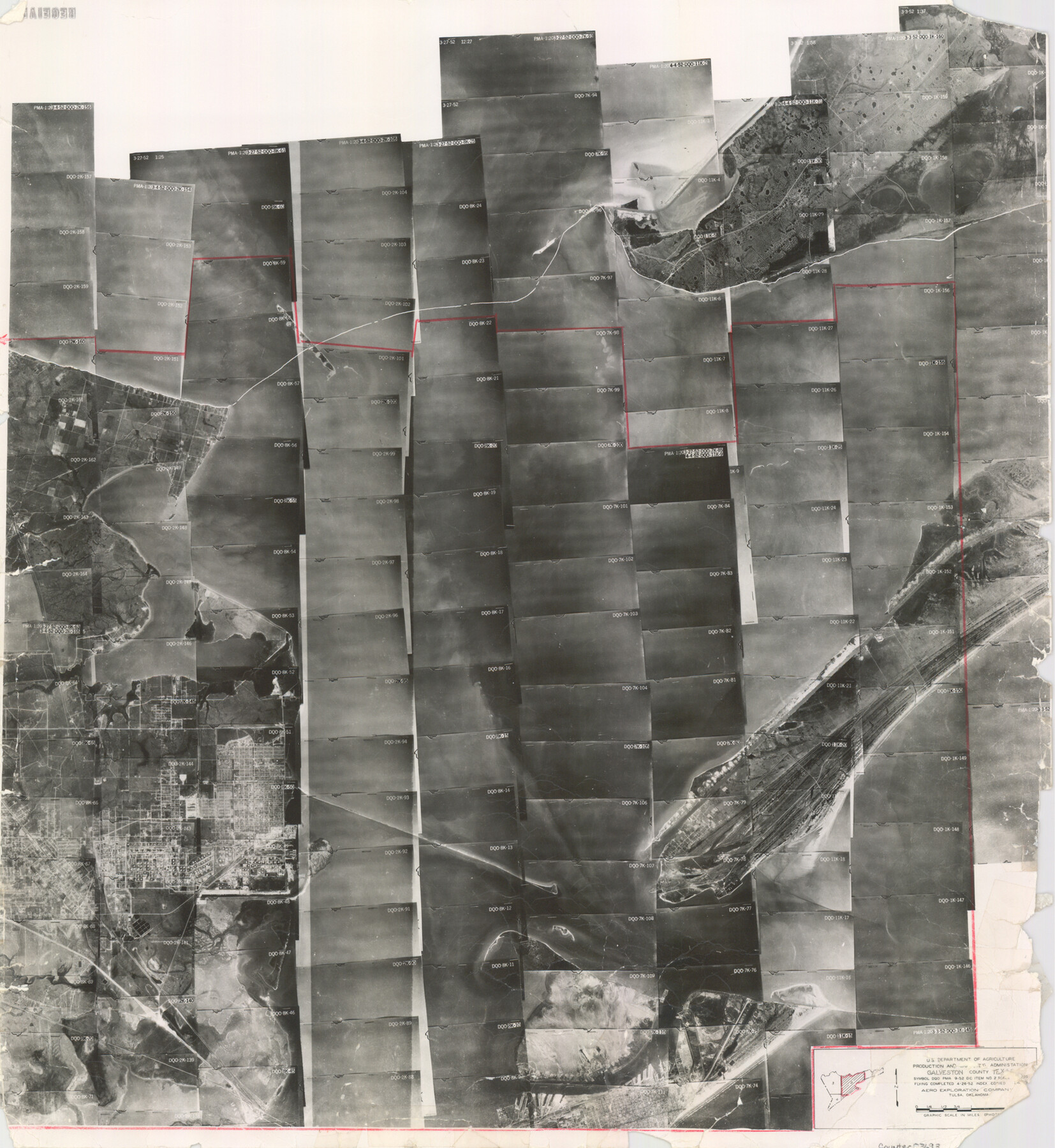
Galveston County Aerial Photograph Index Sheet 2
Galveston County Aerial Photograph Index 2
-
Map/Doc
83693
-
Collection
General Map Collection
-
Object Dates
1953/2/10 (Creation Date)
-
People and Organizations
U. S. Department of Agriculture (Publisher)
-
Counties
Galveston
-
Subjects
Aerial Photograph
-
Height x Width
21.2 x 19.5 inches
53.8 x 49.5 cm
-
Comments
Flying completed April 26, 1952 by Aero Exploration Company of Tulsa, Oklahoma.
Received in office May 17, 1957.
Part of: General Map Collection
Presidio County Rolled Sketch 114

Print $20.00
- Digital $50.00
Presidio County Rolled Sketch 114
Size 28.2 x 40.3 inches
Map/Doc 7390
Map of Ellis County

Print $20.00
- Digital $50.00
Map of Ellis County
1871
Size 19.2 x 27.1 inches
Map/Doc 3509
Lynn County Boundary File 11

Print $44.00
- Digital $50.00
Lynn County Boundary File 11
Size 14.1 x 8.7 inches
Map/Doc 56745
Johnson County Working Sketch 27

Print $20.00
- Digital $50.00
Johnson County Working Sketch 27
2006
Size 37.3 x 44.0 inches
Map/Doc 83651
Pecos County Working Sketch 48

Print $20.00
- Digital $50.00
Pecos County Working Sketch 48
1947
Size 35.0 x 27.7 inches
Map/Doc 71520
Flight Mission No. BQR-13K, Frame 20, Brazoria County

Print $20.00
- Digital $50.00
Flight Mission No. BQR-13K, Frame 20, Brazoria County
1952
Size 18.9 x 22.5 inches
Map/Doc 84068
San Patricio County Sketch File 27

Print $4.00
San Patricio County Sketch File 27
Size 14.5 x 8.8 inches
Map/Doc 36085
Val Verde County Sketch File H

Print $14.00
- Digital $50.00
Val Verde County Sketch File H
1891
Size 8.9 x 6.9 inches
Map/Doc 39291
Jack County Sketch File 15

Print $4.00
- Digital $50.00
Jack County Sketch File 15
1880
Size 7.3 x 13.7 inches
Map/Doc 27545
Flight Mission No. CRC-2R, Frame 133, Chambers County

Print $20.00
- Digital $50.00
Flight Mission No. CRC-2R, Frame 133, Chambers County
1956
Size 18.7 x 22.5 inches
Map/Doc 84749
Mills County Working Sketch 16

Print $20.00
- Digital $50.00
Mills County Working Sketch 16
1963
Size 20.2 x 18.3 inches
Map/Doc 71046
Parker County Sketch File 50

Print $68.00
- Digital $50.00
Parker County Sketch File 50
2022
Size 11.0 x 8.5 inches
Map/Doc 96679
You may also like
Survey of Lots 1 and 2, Desha Bunton Subdivision

Print $20.00
- Digital $50.00
Survey of Lots 1 and 2, Desha Bunton Subdivision
1916
Size 19.6 x 18.4 inches
Map/Doc 487
Comal County Working Sketch 5

Print $20.00
- Digital $50.00
Comal County Working Sketch 5
1950
Size 19.0 x 21.4 inches
Map/Doc 68171
Denton County Working Sketch 7

Print $20.00
- Digital $50.00
Denton County Working Sketch 7
1958
Size 26.0 x 28.8 inches
Map/Doc 68612
Val Verde County Working Sketch 7

Print $20.00
- Digital $50.00
Val Verde County Working Sketch 7
1915
Size 21.9 x 19.5 inches
Map/Doc 72142
La Salle County Sketch File 20A

Print $29.00
- Digital $50.00
La Salle County Sketch File 20A
1852
Size 19.5 x 33.6 inches
Map/Doc 11984
Brazos River, East Waco Sheet

Print $6.00
- Digital $50.00
Brazos River, East Waco Sheet
1928
Size 31.6 x 25.9 inches
Map/Doc 65283
Comal County Rolled Sketch 3

Print $20.00
- Digital $50.00
Comal County Rolled Sketch 3
1977
Size 19.0 x 17.3 inches
Map/Doc 5538
Southern Homes in Southern Texas, The Celebrated Coast Country

Southern Homes in Southern Texas, The Celebrated Coast Country
1899
Size 6.2 x 3.7 inches
Map/Doc 97050
Edwards County Working Sketch 96

Print $20.00
- Digital $50.00
Edwards County Working Sketch 96
1969
Size 25.1 x 34.1 inches
Map/Doc 68972
Flight Mission No. BQR-20K, Frame 11, Brazoria County

Print $20.00
- Digital $50.00
Flight Mission No. BQR-20K, Frame 11, Brazoria County
1952
Size 18.7 x 22.3 inches
Map/Doc 84113
Liberty County Working Sketch 10

Print $40.00
- Digital $50.00
Liberty County Working Sketch 10
1909
Size 38.9 x 48.3 inches
Map/Doc 70469
[Note to Thos. W. Ward to make corrections for J. D. Wheeler, Survey 147 in San Patricio County, San Patricio District]
![69748, [Note to Thos. W. Ward to make corrections for J. D. Wheeler, Survey 147 in San Patricio County, San Patricio District], General Map Collection](https://historictexasmaps.com/wmedia_w700/maps/69748.tif.jpg)
Print $2.00
- Digital $50.00
[Note to Thos. W. Ward to make corrections for J. D. Wheeler, Survey 147 in San Patricio County, San Patricio District]
1842
Size 4.5 x 6.8 inches
Map/Doc 69748