Pecos County Sketch File 114
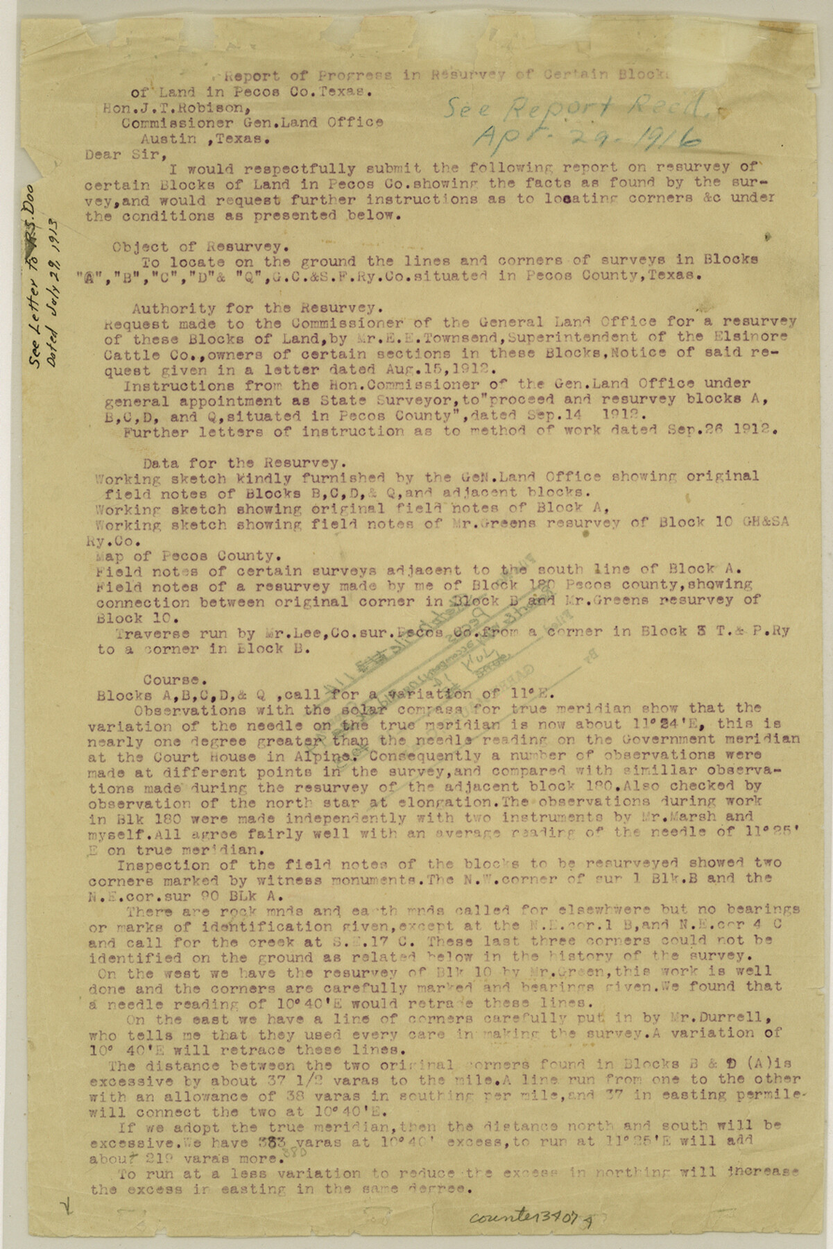
[Report of progress in resurvey of certain Blocks of land in Pecos County]
- 
                          Map/Doc
34074
 - 
                            Collection
General Map Collection
 - 
                            Object Dates
12/1912 (Creation Date)
7/14/1913 (File Date)
7/29/1913 (Correspondence Date)
 - 
                            People and Organizations
R.S. Dod (Surveyor/Engineer)
L.W. Durrell (Surveyor/Engineer)
J.A. Greene (Surveyor/Engineer)
J.T. Robison (GLO Commissioner)
 - 
                            Counties
Pecos Brewster
 - 
                            Subjects
Surveying Sketch File
 - 
                            Height x Width
13.3 x 8.9 inches
33.8 x 22.6 cm
 - 
                            Medium
paper, print
 - 
                            Comments
See Pecos County Rolled Sketch 44 (7222) for sketch.
 - 
                            Features
Antelope North
Old Government Road to Fort Stockton
 
Related maps
            Pecos County Rolled Sketch 44


                                            Print $20.00                    
                                             -                         Digital $50.00                                    
                Pecos County Rolled Sketch 44
1912
Size 22.9 x 37.6 inches
                                Map/Doc 7222
            Part of: General Map Collection
            Texas Intracoastal Waterway - Laguna Madre - Dagger Hill to Potrero Grande


                                            Print $20.00                    
                                             -                         Digital $50.00                                    
                Texas Intracoastal Waterway - Laguna Madre - Dagger Hill to Potrero Grande
1960
Size 38.3 x 27.0 inches
                                Map/Doc 73511
            
            Hamilton County Working Sketch 28


                                            Print $20.00                    
                                             -                         Digital $50.00                                    
                Hamilton County Working Sketch 28
1976
Size 27.7 x 33.2 inches
                                Map/Doc 63366
            
            Revised Map of Calvert, Robertson County, Texas


                                            Print $20.00                    
                                             -                         Digital $50.00                                    
                Revised Map of Calvert, Robertson County, Texas
Size 25.4 x 19.4 inches
                                Map/Doc 88741
            
            Dallas County Sketch File 15


                                            Print $10.00                    
                                             -                         Digital $50.00                                    
                Dallas County Sketch File 15
1863
Size 11.5 x 8.5 inches
                                Map/Doc 20430
            
            Scurry County Sketch File 4


                                            Print $26.00                    
                                             -                         Digital $50.00                                    
                Scurry County Sketch File 4
1881
Size 13.1 x 8.5 inches
                                Map/Doc 36565
            
            Grayson County Working Sketch 21


                                            Print $20.00                    
                                             -                         Digital $50.00                                    
                Grayson County Working Sketch 21
1961
Size 42.6 x 26.5 inches
                                Map/Doc 63260
            
            Map of Caldwell County


                                            Print $20.00                    
                                             -                         Digital $50.00                                    
                Map of Caldwell County
1871
Size 16.9 x 19.8 inches
                                Map/Doc 4590
            
            Jefferson County Sketch File 26a


                                            Print $20.00                    
                                             -                         Digital $50.00                                    
                Jefferson County Sketch File 26a
Size 19.5 x 11.6 inches
                                Map/Doc 11872
            
            Bastrop County Working Sketch 3


                                            Print $20.00                    
                                             -                         Digital $50.00                                    
                Bastrop County Working Sketch 3
1921
Size 22.9 x 15.4 inches
                                Map/Doc 67303
            
            [Sketch of expeditions, trails in Jones, Taylor, Shackelford, Callahan, Buchanan/Stephens and Eastland Counties]


                                            Print $4.00                    
                                             -                         Digital $50.00                                    
                [Sketch of expeditions, trails in Jones, Taylor, Shackelford, Callahan, Buchanan/Stephens and Eastland Counties]
1873
Size 10.7 x 18.1 inches
                                Map/Doc 65406
            
            Wichita County Working Sketch 25


                                            Print $20.00                    
                                             -                         Digital $50.00                                    
                Wichita County Working Sketch 25
1980
Size 27.1 x 27.7 inches
                                Map/Doc 72535
            
            Throckmorton County Working Sketch 2


                                            Print $20.00                    
                                             -                         Digital $50.00                                    
                Throckmorton County Working Sketch 2
1919
Size 20.9 x 16.9 inches
                                Map/Doc 62111
            You may also like
            General Highway Map, Gillespie County, Texas


                                            Print $20.00                    
                                    
                General Highway Map, Gillespie County, Texas
1940
Size 18.2 x 24.9 inches
                                Map/Doc 79099
            
            Flight Mission No. CRC-4R, Frame 159, Chambers County


                                            Print $20.00                    
                                             -                         Digital $50.00                                    
                Flight Mission No. CRC-4R, Frame 159, Chambers County
1956
Size 18.6 x 22.2 inches
                                Map/Doc 84918
            
            Fannin County Sketch File 13


                                            Print $4.00                    
                                             -                         Digital $50.00                                    
                Fannin County Sketch File 13
Size 8.1 x 7.9 inches
                                Map/Doc 22462
            
            Cass County Working Sketch 24


                                            Print $20.00                    
                                             -                         Digital $50.00                                    
                Cass County Working Sketch 24
1973
Size 35.6 x 27.7 inches
                                Map/Doc 67927
            
            Flight Mission No. CRC-2R, Frame 62, Chambers County


                                            Print $20.00                    
                                             -                         Digital $50.00                                    
                Flight Mission No. CRC-2R, Frame 62, Chambers County
1956
Size 18.6 x 22.5 inches
                                Map/Doc 84733
            
            Flight Mission No. CUG-3P, Frame 83, Kleberg County


                                            Print $20.00                    
                                             -                         Digital $50.00                                    
                Flight Mission No. CUG-3P, Frame 83, Kleberg County
1956
Size 18.7 x 22.4 inches
                                Map/Doc 86258
            
            Midland County Boundary File 1a


                                            Print $4.00                    
                                             -                         Digital $50.00                                    
                Midland County Boundary File 1a
Size 9.5 x 6.0 inches
                                Map/Doc 57160
            
            Plat of a survey on Padre Island in Willacy County surveyed for South Padre Development Corporation by Claunch and Associates


                                            Print $40.00                    
                                             -                         Digital $50.00                                    
                Plat of a survey on Padre Island in Willacy County surveyed for South Padre Development Corporation by Claunch and Associates
1973
Size 73.7 x 42.8 inches
                                Map/Doc 61426
            
            Coast of Texas from head of East Bay Galveston Harbor to Sabine Pass


                                            Print $40.00                    
                                             -                         Digital $50.00                                    
                Coast of Texas from head of East Bay Galveston Harbor to Sabine Pass
1882
Size 32.6 x 54.1 inches
                                Map/Doc 69838
            
            Shackelford County Sketch File 8


                                            Print $44.00                    
                                             -                         Digital $50.00                                    
                Shackelford County Sketch File 8
1936
Size 11.5 x 8.8 inches
                                Map/Doc 59290
            
            Brewster County Working Sketch 75


                                            Print $20.00                    
                                             -                         Digital $50.00                                    
                Brewster County Working Sketch 75
1967
Size 28.3 x 36.9 inches
                                Map/Doc 67675
            
            Flight Mission No. CUG-3P, Frame 11, Kleberg County


                                            Print $20.00                    
                                             -                         Digital $50.00                                    
                Flight Mission No. CUG-3P, Frame 11, Kleberg County
1956
Size 18.5 x 22.2 inches
                                Map/Doc 86221