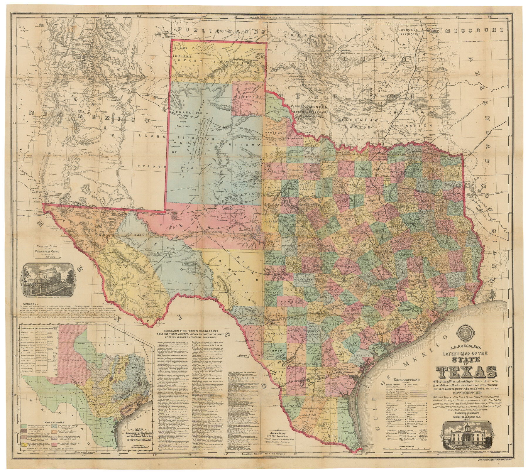
A.R. Roessler's Latest Map of the State of Texas Exhibiting Mineral and Agricultural Districts, Post Offices & Mailroutes, Railroads projected and finished, Timber, Prairie, Swamp Lands, etc. etc. etc.
Inset: Map Showing Agricultural Districts and Varieties of Soils in the State of Texas
-
Map/Doc
95369
-
Collection
Holcomb Digital Map Collection
-
Object Dates
1874 (Creation Date)
-
People and Organizations
Ferd. Mayer (Printer)
M.V. Mittendorfer (Draftsman)
M.V. Mittendorfer (Compiler)
-
Subjects
State of Texas
-
Height x Width
39.9 x 44.6 inches
101.3 x 113.3 cm
-
Medium
digital image
-
Comments
Courtesy of Frank and Carol Holcomb.
Part of: Holcomb Digital Map Collection
The Scarborough Company's New Railroad, Post Office & County Map of Texas, Oklahoma and Indian Territory Compiled from the Latest Government Surveys and Original Sources

Print $20.00
- Digital $50.00
The Scarborough Company's New Railroad, Post Office & County Map of Texas, Oklahoma and Indian Territory Compiled from the Latest Government Surveys and Original Sources
1904
Size 42.8 x 46.6 inches
Map/Doc 93911
Map of the West Indies designed to accompany Smith's Geography for Schools

Print $20.00
- Digital $50.00
Map of the West Indies designed to accompany Smith's Geography for Schools
1850
Size 9.6 x 12.0 inches
Map/Doc 93893
Map of the Colonization Grants to Zavala, Vehlein & Burnet in Texas, belonging to the Galveston Bay & Texas Land Co.

Print $20.00
- Digital $50.00
Map of the Colonization Grants to Zavala, Vehlein & Burnet in Texas, belonging to the Galveston Bay & Texas Land Co.
1835
Size 10.7 x 12.7 inches
Map/Doc 93851
America sive novvs orbis respectv evropaeorvm inferior globi terrestris pars 1596

Print $20.00
- Digital $50.00
America sive novvs orbis respectv evropaeorvm inferior globi terrestris pars 1596
1596
Size 14.7 x 18.1 inches
Map/Doc 93809
Map of the British Isles designed to accompany Smith's Geography for Schools

Print $20.00
- Digital $50.00
Map of the British Isles designed to accompany Smith's Geography for Schools
1850
Size 12.1 x 9.8 inches
Map/Doc 93894
Map No. 2. Eastern States designed to accompany Smith's Geography for School

Print $20.00
- Digital $50.00
Map No. 2. Eastern States designed to accompany Smith's Geography for School
1850
Size 9.6 x 12.1 inches
Map/Doc 93886
Traveller's Map of the State of Texas

Print $20.00
- Digital $50.00
Traveller's Map of the State of Texas
1867
Size 43.4 x 41.6 inches
Map/Doc 93906
A Map of Louisiana and Mexico

Print $20.00
- Digital $50.00
A Map of Louisiana and Mexico
1820
Size 43.8 x 32.9 inches
Map/Doc 94945
Karte von Texas entworfen nach den Vermessungen welche in den Acten der General-Land-Office der Republick

Print $20.00
- Digital $50.00
Karte von Texas entworfen nach den Vermessungen welche in den Acten der General-Land-Office der Republick
1846
Size 16.9 x 17.6 inches
Map/Doc 94118
Map of Asia designed to accompany Smith's Geography for Schools

Print $20.00
- Digital $50.00
Map of Asia designed to accompany Smith's Geography for Schools
1850
Size 9.6 x 12.0 inches
Map/Doc 93896
Map of the Western States designed to accompany Smith's Geography for Schools

Print $20.00
- Digital $50.00
Map of the Western States designed to accompany Smith's Geography for Schools
1850
Size 12.2 x 19.1 inches
Map/Doc 93889
Americae Pars Borealis, Florida, Baccalaos, Canada, Corterealis

Print $20.00
- Digital $50.00
Americae Pars Borealis, Florida, Baccalaos, Canada, Corterealis
1593
Size 16.2 x 22.1 inches
Map/Doc 93832
You may also like
Sheet 2 copied from Peck Book 6 [Strip Map showing T. & P. connecting lines]
![93172, Sheet 2 copied from Peck Book 6 [Strip Map showing T. & P. connecting lines], Twichell Survey Records](https://historictexasmaps.com/wmedia_w700/maps/93172-1.tif.jpg)
Print $40.00
- Digital $50.00
Sheet 2 copied from Peck Book 6 [Strip Map showing T. & P. connecting lines]
1909
Size 6.5 x 53.9 inches
Map/Doc 93172
Midland County Rolled Sketch 11

Print $20.00
- Digital $50.00
Midland County Rolled Sketch 11
Size 45.7 x 26.2 inches
Map/Doc 6767
Map of Jasper and Newton Counties

Print $20.00
- Digital $50.00
Map of Jasper and Newton Counties
1862
Size 36.5 x 25.8 inches
Map/Doc 3714
A Map of Louisiana and Mexico
Print $20.00
- Digital $50.00
A Map of Louisiana and Mexico
1820
Size 43.8 x 32.9 inches
Map/Doc 94945
Lamar County Boundary File 56a

Print $34.00
- Digital $50.00
Lamar County Boundary File 56a
Size 8.7 x 14.3 inches
Map/Doc 56020
Val Verde County Sketch File Z22

Print $4.00
- Digital $50.00
Val Verde County Sketch File Z22
1919
Size 11.2 x 8.6 inches
Map/Doc 39163
Hemphill County Rolled Sketch 10

Print $20.00
- Digital $50.00
Hemphill County Rolled Sketch 10
Size 19.4 x 27.6 inches
Map/Doc 6192
The Republic County of Liberty. December 29, 1845

Print $20.00
The Republic County of Liberty. December 29, 1845
2020
Size 19.9 x 21.7 inches
Map/Doc 96213
Hutchinson County Working Sketch 39

Print $20.00
- Digital $50.00
Hutchinson County Working Sketch 39
1978
Size 27.4 x 23.2 inches
Map/Doc 66399
Lampasas County Working Sketch 8

Print $20.00
- Digital $50.00
Lampasas County Working Sketch 8
1958
Size 36.4 x 37.1 inches
Map/Doc 70285
[Panhandle Counties]
![89923, [Panhandle Counties], Twichell Survey Records](https://historictexasmaps.com/wmedia_w700/maps/89923-1.tif.jpg)
Print $20.00
- Digital $50.00
[Panhandle Counties]
1930
Size 42.3 x 42.8 inches
Map/Doc 89923
Flight Mission No. DIX-6P, Frame 126, Aransas County

Print $20.00
- Digital $50.00
Flight Mission No. DIX-6P, Frame 126, Aransas County
1956
Size 19.3 x 22.9 inches
Map/Doc 83832