![89923, [Panhandle Counties], Twichell Survey Records](https://historictexasmaps.com/wmedia_w1800h1800/maps/89923-1.tif.jpg)
[Panhandle Counties]
85-2
-
Map/Doc
89923
-
Collection
Twichell Survey Records
-
Object Dates
1930 (Creation Date)
-
Counties
Garza
-
Height x Width
42.3 x 42.8 inches
107.4 x 108.7 cm
Part of: Twichell Survey Records
![90713, [Capitol Lands], Twichell Survey Records](https://historictexasmaps.com/wmedia_w700/maps/90713-1.tif.jpg)
Yates Pool, Pecos County, Texas

Print $20.00
- Digital $50.00
Yates Pool, Pecos County, Texas
1920
Size 17.5 x 15.7 inches
Map/Doc 91564
[Kent County Block 4, Sections 33 and 46, Block 97, Sections 771 and 772]
![92192, [Kent County Block 4, Sections 33 and 46, Block 97, Sections 771 and 772], Twichell Survey Records](https://historictexasmaps.com/wmedia_w700/maps/92192-1.tif.jpg)
Print $2.00
- Digital $50.00
[Kent County Block 4, Sections 33 and 46, Block 97, Sections 771 and 772]
1951
Size 8.7 x 15.6 inches
Map/Doc 92192
Block 36, Township 3 North

Print $20.00
- Digital $50.00
Block 36, Township 3 North
Size 12.0 x 15.9 inches
Map/Doc 91289
Nine Central Panhandle Counties, Texas

Print $20.00
- Digital $50.00
Nine Central Panhandle Counties, Texas
1899
Size 41.3 x 35.0 inches
Map/Doc 93045
[Blocks J, 24, 5, 8, 2, 1 and vicinity]
![92663, [Blocks J, 24, 5, 8, 2, 1 and vicinity], Twichell Survey Records](https://historictexasmaps.com/wmedia_w700/maps/92663-1.tif.jpg)
Print $40.00
- Digital $50.00
[Blocks J, 24, 5, 8, 2, 1 and vicinity]
Size 54.0 x 32.2 inches
Map/Doc 92663
Sketch for Blocks D6, D7, D8 situated in Val Verde County, Texas

Print $40.00
- Digital $50.00
Sketch for Blocks D6, D7, D8 situated in Val Verde County, Texas
1937
Size 100.1 x 40.0 inches
Map/Doc 93166
![91538, [Block 3T], Twichell Survey Records](https://historictexasmaps.com/wmedia_w700/maps/91538-1.tif.jpg)
Roberts & McWhorter Addition

Print $20.00
- Digital $50.00
Roberts & McWhorter Addition
Size 31.0 x 30.6 inches
Map/Doc 93219
[East County Line]
![90225, [East County Line], Twichell Survey Records](https://historictexasmaps.com/wmedia_w700/maps/90225-1.tif.jpg)
Print $20.00
- Digital $50.00
[East County Line]
Size 38.2 x 11.7 inches
Map/Doc 90225
Sections 13 & 12, Block S

Print $20.00
- Digital $50.00
Sections 13 & 12, Block S
Size 23.0 x 18.2 inches
Map/Doc 92835
[Blocks S and H1]
![91436, [Blocks S and H1], Twichell Survey Records](https://historictexasmaps.com/wmedia_w700/maps/91436-1.tif.jpg)
Print $20.00
- Digital $50.00
[Blocks S and H1]
Size 23.0 x 10.2 inches
Map/Doc 91436
You may also like
Matagorda County Aerial Photograph Index Sheet 6

Print $20.00
- Digital $50.00
Matagorda County Aerial Photograph Index Sheet 6
1953
Size 23.8 x 19.6 inches
Map/Doc 83727
Upton County Sketch File R

Print $4.00
- Digital $50.00
Upton County Sketch File R
Size 13.4 x 8.8 inches
Map/Doc 38848
Dickens County Sketch File 17

Print $6.00
- Digital $50.00
Dickens County Sketch File 17
1909
Size 12.2 x 11.8 inches
Map/Doc 20977
Newton County Rolled Sketch 25
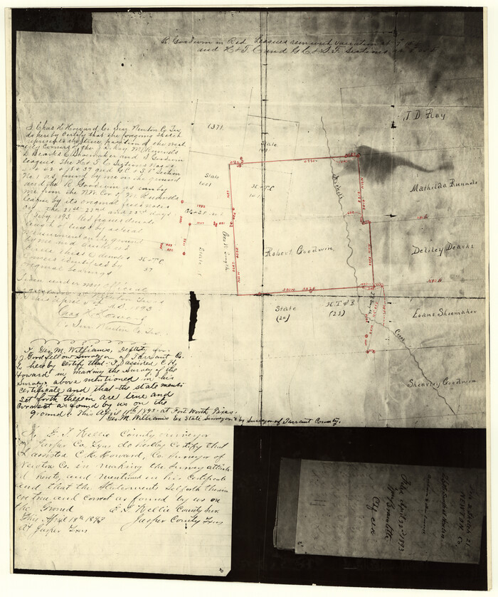
Print $20.00
- Digital $50.00
Newton County Rolled Sketch 25
1893
Size 22.4 x 18.7 inches
Map/Doc 6853
Flight Mission No. DAG-18K, Frame 77, Matagorda County

Print $20.00
- Digital $50.00
Flight Mission No. DAG-18K, Frame 77, Matagorda County
1952
Size 18.5 x 22.3 inches
Map/Doc 86370
Real County Working Sketch 59

Print $20.00
- Digital $50.00
Real County Working Sketch 59
1962
Size 27.4 x 40.7 inches
Map/Doc 71951
Titus County Working Sketch 6

Print $40.00
- Digital $50.00
Titus County Working Sketch 6
1962
Size 29.8 x 55.5 inches
Map/Doc 69367
Duval County Rolled Sketch 48

Print $20.00
- Digital $50.00
Duval County Rolled Sketch 48
Size 21.8 x 18.5 inches
Map/Doc 5762
Archer County Sketch File 8

Print $40.00
- Digital $50.00
Archer County Sketch File 8
Size 40.9 x 31.5 inches
Map/Doc 10336
Crockett County Working Sketch 29

Print $40.00
- Digital $50.00
Crockett County Working Sketch 29
1924
Size 42.8 x 57.6 inches
Map/Doc 68362
[Map of the San Antonio del Encinal as Corrected]
![4459, [Map of the San Antonio del Encinal as Corrected], Maddox Collection](https://historictexasmaps.com/wmedia_w700/maps/4459.tif.jpg)
Print $20.00
- Digital $50.00
[Map of the San Antonio del Encinal as Corrected]
Size 28.5 x 30.7 inches
Map/Doc 4459
Current Miscellaneous File 25

Print $24.00
- Digital $50.00
Current Miscellaneous File 25
1953
Size 10.6 x 8.2 inches
Map/Doc 73897