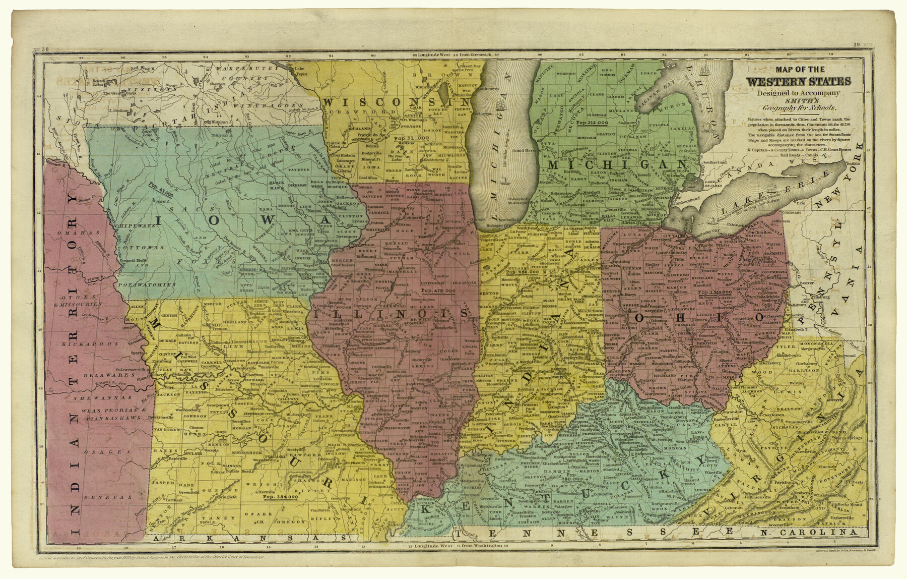
Map of the Western States designed to accompany Smith's Geography for Schools
-
Map/Doc
93889
-
Collection
Holcomb Digital Map Collection
-
Object Dates
1850 (Creation Date)
-
People and Organizations
Stiles, Sherman and Smith (Printer)
Stiles, Sherman and Smith (Draftsman)
-
Subjects
Atlas
-
Height x Width
12.2 x 19.1 inches
31.0 x 48.5 cm
-
Comments
Courtesy of Frank and Carol Holcomb.
Part of: Holcomb Digital Map Collection
J. De Cordova's Map of the State of Texas Compiled from the records of the General Land Office of the State

Print $2.00
- Digital $50.00
J. De Cordova's Map of the State of Texas Compiled from the records of the General Land Office of the State
1855
Size 6.8 x 4.0 inches
Map/Doc 93912
Map of Texas compiled from surveys included in the General Land Office

Print $20.00
- Digital $50.00
Map of Texas compiled from surveys included in the General Land Office
1851
Size 31.4 x 25.3 inches
Map/Doc 94417
Texas, Oregon and California [Cover and accompaniment]
![93873, Texas, Oregon and California [Cover and accompaniment], Holcomb Digital Map Collection](https://historictexasmaps.com/wmedia_w700/pdf_converted_jpg/qi_pdf_thumbnail_38543.jpg)
Print $108.00
- Digital $50.00
Texas, Oregon and California [Cover and accompaniment]
1846
Size 5.4 x 3.4 inches
Map/Doc 93873
Map of Texas and the Countries Adjacent compiled in the Bureau of the Corps of Topographical Engineers from the Best Authorities

Print $20.00
- Digital $50.00
Map of Texas and the Countries Adjacent compiled in the Bureau of the Corps of Topographical Engineers from the Best Authorities
1844
Size 22.3 x 33.4 inches
Map/Doc 93867
Map of the Middle States designed to accompany Smith's Geography for Schools

Print $20.00
- Digital $50.00
Map of the Middle States designed to accompany Smith's Geography for Schools
1850
Size 19.4 x 12.2 inches
Map/Doc 93887
Trace d'une partie Chemin de Fer de Galveston à Houston et Henderson, Texas, Etats unis d'Amérique

Print $20.00
- Digital $50.00
Trace d'une partie Chemin de Fer de Galveston à Houston et Henderson, Texas, Etats unis d'Amérique
1857
Size 17.1 x 21.8 inches
Map/Doc 93905
Carte du Mexique et de la Floride des Terres Angloises et des Isles Antilles du cours et des environs de la Riviere de Mississipi

Print $20.00
- Digital $50.00
Carte du Mexique et de la Floride des Terres Angloises et des Isles Antilles du cours et des environs de la Riviere de Mississipi
1703
Size 19.0 x 25.8 inches
Map/Doc 96519
Colton's New Map of the State of Texas, the Indian Territory and adjoining portions of New Mexico, Louisiana and Arkansas

Print $20.00
- Digital $50.00
Colton's New Map of the State of Texas, the Indian Territory and adjoining portions of New Mexico, Louisiana and Arkansas
1882
Size 32.8 x 37.3 inches
Map/Doc 93909
Map of Michigan and Wisconsin designed to accompany Smith's Geography for Schools

Print $20.00
- Digital $50.00
Map of Michigan and Wisconsin designed to accompany Smith's Geography for Schools
1850
Size 9.7 x 12.1 inches
Map/Doc 93890
Texas (verso)

Print $20.00
- Digital $50.00
Texas (verso)
1833
Size 19.1 x 22.8 inches
Map/Doc 93837
Map of the Texas & Pacific Railway and connections

Print $20.00
- Digital $50.00
Map of the Texas & Pacific Railway and connections
1902
Size 18.0 x 36.8 inches
Map/Doc 95413
Amèrica noviter delineata

Print $20.00
- Digital $50.00
Amèrica noviter delineata
1630
Size 21.5 x 24.7 inches
Map/Doc 93814
You may also like
[I. & G. N. Sections 11, 12, and 13]
![91039, [I. & G. N. Sections 11, 12, and 13], Twichell Survey Records](https://historictexasmaps.com/wmedia_w700/maps/91039-1.tif.jpg)
Print $20.00
- Digital $50.00
[I. & G. N. Sections 11, 12, and 13]
Size 24.7 x 15.6 inches
Map/Doc 91039
Flight Mission No. BRA-16M, Frame 168, Jefferson County

Print $20.00
- Digital $50.00
Flight Mission No. BRA-16M, Frame 168, Jefferson County
1953
Size 18.7 x 22.5 inches
Map/Doc 85766
West Half - Brown County

Print $40.00
- Digital $50.00
West Half - Brown County
1982
Size 142.2 x 37.3 inches
Map/Doc 97384
Water Valley Sheet, North Concho River, Tom Green County

Print $20.00
- Digital $50.00
Water Valley Sheet, North Concho River, Tom Green County
1937
Size 23.6 x 19.1 inches
Map/Doc 65305
Fractional Township No. 7 South Range No. 7 East of the Indian Meridian, Indian Territory

Print $20.00
- Digital $50.00
Fractional Township No. 7 South Range No. 7 East of the Indian Meridian, Indian Territory
1898
Size 19.2 x 24.3 inches
Map/Doc 75212
Live Oak County Rolled Sketch 7

Print $20.00
- Digital $50.00
Live Oak County Rolled Sketch 7
1951
Size 31.3 x 36.9 inches
Map/Doc 6635
Lipscomb County Rolled Sketch 8

Print $40.00
- Digital $50.00
Lipscomb County Rolled Sketch 8
1940
Size 59.2 x 28.5 inches
Map/Doc 9453
[Sketch Showing Surveys in Dimmit County, Texas]
![5045, [Sketch Showing Surveys in Dimmit County, Texas], Maddox Collection](https://historictexasmaps.com/wmedia_w700/maps/5045.tif.jpg)
Print $20.00
- Digital $50.00
[Sketch Showing Surveys in Dimmit County, Texas]
Size 20.1 x 16.7 inches
Map/Doc 5045
Jeff Davis County Rolled Sketch 31

Print $20.00
- Digital $50.00
Jeff Davis County Rolled Sketch 31
1983
Size 40.6 x 44.1 inches
Map/Doc 9268
Falls County Sketch File 18

Print $4.00
- Digital $50.00
Falls County Sketch File 18
Size 10.3 x 8.2 inches
Map/Doc 22380
[Surveys just south of Runnels County School Land Survey No. 3]
![91552, [Surveys just south of Runnels County School Land Survey No. 3], Twichell Survey Records](https://historictexasmaps.com/wmedia_w700/maps/91552-1.tif.jpg)
Print $20.00
- Digital $50.00
[Surveys just south of Runnels County School Land Survey No. 3]
1926
Size 19.4 x 13.1 inches
Map/Doc 91552
Morris County Rolled Sketch 2A

Print $20.00
- Digital $50.00
Morris County Rolled Sketch 2A
Size 22.6 x 17.7 inches
Map/Doc 10285