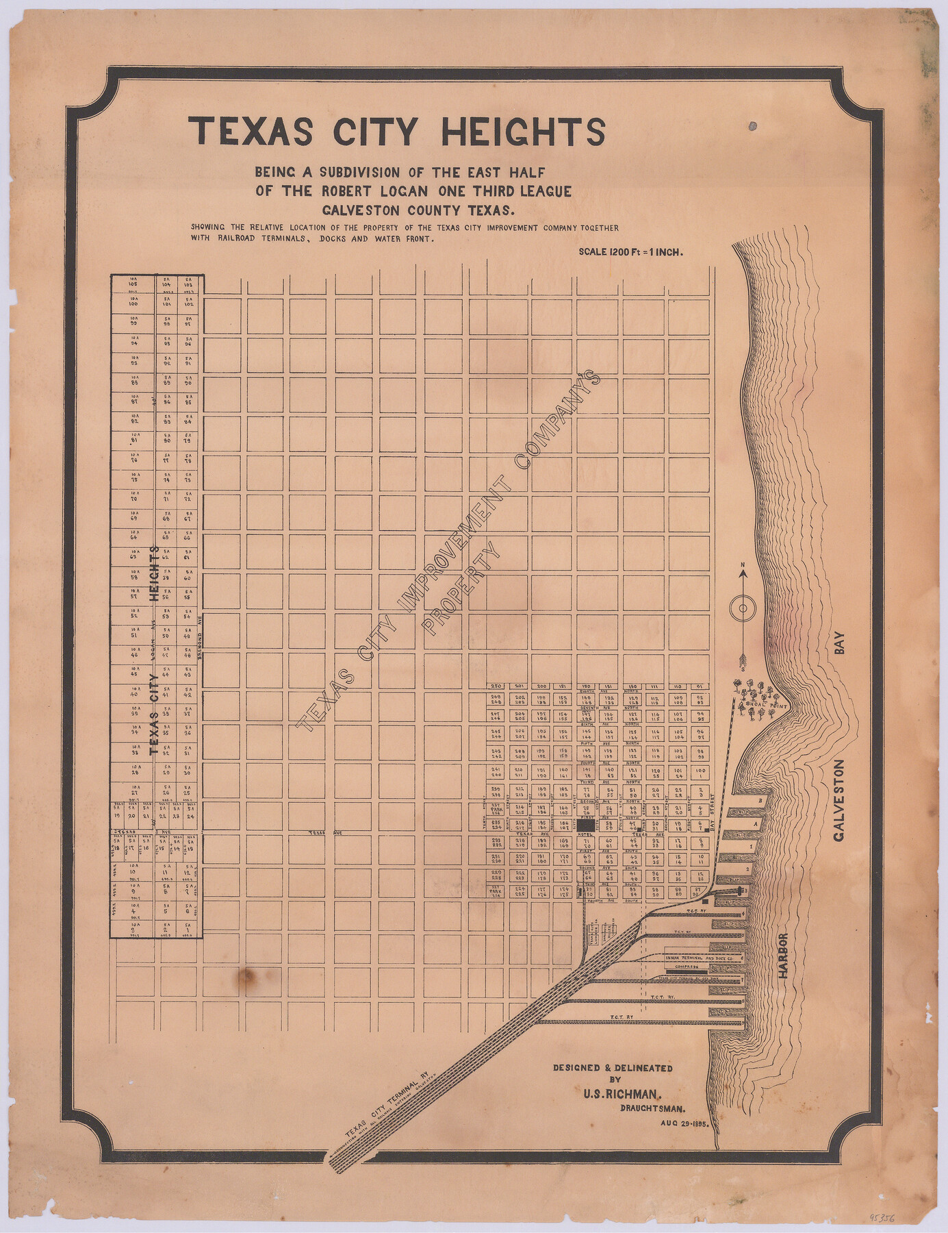
Texas City Heights being a subdivision of the east half of the Robert Logan one third league, Galveston County, Texas
Showing the relative location of the property of the Texas City Improvement Company together with railroad terminals, docks and water front
-
Map/Doc
95356
-
Collection
General Map Collection
-
Object Dates
1895/8/29 (Creation Date)
-
People and Organizations
U.S. Richman (Draftsman)
-
Counties
Galveston
-
Subjects
City
-
Height x Width
22.4 x 17.3 inches
56.9 x 43.9 cm
-
Medium
paper, etching/engraving/lithograph
-
Scale
1" = 1200 feet
Part of: General Map Collection
Map of Clear Lake Shores

Print $20.00
- Digital $50.00
Map of Clear Lake Shores
1927
Size 36.9 x 46.2 inches
Map/Doc 4843
Dimmit County Sketch File 19 1/2a

Print $12.00
- Digital $50.00
Dimmit County Sketch File 19 1/2a
1887
Size 14.2 x 8.8 inches
Map/Doc 21094
[United States]
![97197, [United States], General Map Collection](https://historictexasmaps.com/wmedia_w700/maps/97197.tif.jpg)
Print $20.00
- Digital $50.00
[United States]
1848
Size 17.7 x 37.4 inches
Map/Doc 97197
Denton County Sketch File 29 1/2

Print $4.00
- Digital $50.00
Denton County Sketch File 29 1/2
Size 14.8 x 9.1 inches
Map/Doc 20758
Potter County Sketch File 10

Print $40.00
- Digital $50.00
Potter County Sketch File 10
Size 58.9 x 37.7 inches
Map/Doc 10576
Shackelford County Working Sketch 14

Print $20.00
- Digital $50.00
Shackelford County Working Sketch 14
2008
Size 47.7 x 29.2 inches
Map/Doc 88835
Lampasas County Sketch File 3

Print $4.00
- Digital $50.00
Lampasas County Sketch File 3
1856
Size 12.1 x 7.6 inches
Map/Doc 29392
[Sketch for Mineral Application 15273 - Sabine River Bed]
![65575, [Sketch for Mineral Application 15273 - Sabine River Bed], General Map Collection](https://historictexasmaps.com/wmedia_w700/maps/65575-GC.tif.jpg)
Print $20.00
- Digital $50.00
[Sketch for Mineral Application 15273 - Sabine River Bed]
1926
Size 28.2 x 45.5 inches
Map/Doc 65575
Brewster County Rolled Sketch 126

Print $225.00
- Digital $50.00
Brewster County Rolled Sketch 126
1908
Map/Doc 43230
Pecos County Rolled Sketch 158

Print $20.00
- Digital $50.00
Pecos County Rolled Sketch 158
1961
Size 21.9 x 27.4 inches
Map/Doc 7284
Hutchinson County Sketch File 27

Print $20.00
- Digital $50.00
Hutchinson County Sketch File 27
Size 21.0 x 24.9 inches
Map/Doc 11817
Orange County Rolled Sketch 20

Print $40.00
- Digital $50.00
Orange County Rolled Sketch 20
1947
Size 35.2 x 64.3 inches
Map/Doc 9645
You may also like
La Salle County Working Sketch 4

Print $20.00
- Digital $50.00
La Salle County Working Sketch 4
1915
Size 31.6 x 36.6 inches
Map/Doc 70305
Concho County Rolled Sketch 1A

Print $20.00
- Digital $50.00
Concho County Rolled Sketch 1A
1930
Size 17.9 x 24.5 inches
Map/Doc 5544
[East line of Lipscomb County along Oklahoma]
![89823, [East line of Lipscomb County along Oklahoma], Twichell Survey Records](https://historictexasmaps.com/wmedia_w700/maps/89823-1.tif.jpg)
Print $40.00
- Digital $50.00
[East line of Lipscomb County along Oklahoma]
Size 9.9 x 69.1 inches
Map/Doc 89823

Correct map of the Chicago, Burlington and Quincy Rail Road and its principal connecting lines

Print $20.00
- Digital $50.00
Correct map of the Chicago, Burlington and Quincy Rail Road and its principal connecting lines
1881
Size 27.7 x 38.6 inches
Map/Doc 93956
Archer County Sketch File 3

Print $4.00
- Digital $50.00
Archer County Sketch File 3
Size 7.5 x 8.5 inches
Map/Doc 13628
Flight Mission No. BQY-15M, Frame 14, Harris County

Print $20.00
- Digital $50.00
Flight Mission No. BQY-15M, Frame 14, Harris County
1953
Size 18.6 x 22.4 inches
Map/Doc 85312
Flight Mission No. DAH-17M, Frame 66, Orange County

Print $20.00
- Digital $50.00
Flight Mission No. DAH-17M, Frame 66, Orange County
1953
Size 18.6 x 22.3 inches
Map/Doc 86900
A Map of Austin's Colony and adjacent country in Texas drawn principally from actual survey by Stephen F. Austin

A Map of Austin's Colony and adjacent country in Texas drawn principally from actual survey by Stephen F. Austin
1820
Size 13.8 x 17.0 inches
Map/Doc 93353
Edwards County Sketch File 41

Print $20.00
- Digital $50.00
Edwards County Sketch File 41
Size 33.7 x 22.7 inches
Map/Doc 11439
Flight Mission No. BRE-1P, Frame 7, Nueces County

Print $20.00
- Digital $50.00
Flight Mission No. BRE-1P, Frame 7, Nueces County
1956
Size 18.3 x 22.1 inches
Map/Doc 86615
Working Sketch in Wichita County [in northern part of county]
![91992, Working Sketch in Wichita County [in northern part of county], Twichell Survey Records](https://historictexasmaps.com/wmedia_w700/maps/91992-1.tif.jpg)
Print $20.00
- Digital $50.00
Working Sketch in Wichita County [in northern part of county]
1919
Size 38.3 x 18.5 inches
Map/Doc 91992