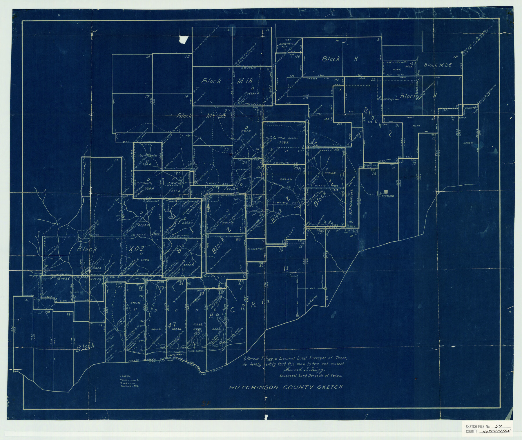
Hutchinson County Sketch File 27
Sk. By H. T. Trigg Lying North of Canadian R. submitted in connection with S. F. 12516
-
Map/Doc
11817
-
Collection
General Map Collection
-
Object Dates
10/23/1923 (File Date)
-
People and Organizations
Howard T. Trigg (Surveyor/Engineer)
-
Counties
Hutchinson
-
Subjects
Surveying Sketch File
-
Height x Width
21.0 x 24.9 inches
53.3 x 63.2 cm
-
Medium
blueprint/diazo
-
Features
Plemons
Part of: General Map Collection
El Paso County Boundary File 7a

Print $20.00
- Digital $50.00
El Paso County Boundary File 7a
Size 14.2 x 8.3 inches
Map/Doc 53094
Live Oak County Working Sketch 15

Print $20.00
- Digital $50.00
Live Oak County Working Sketch 15
1952
Size 23.8 x 22.6 inches
Map/Doc 70600
Moore County Working Sketch 1

Print $20.00
- Digital $50.00
Moore County Working Sketch 1
1909
Size 32.0 x 32.4 inches
Map/Doc 71183
Aransas County Rolled Sketch 15B

Print $20.00
- Digital $50.00
Aransas County Rolled Sketch 15B
Size 19.0 x 19.8 inches
Map/Doc 76066
[University Lands]
![62966, [University Lands], General Map Collection](https://historictexasmaps.com/wmedia_w700/maps/62966.tif.jpg)
Print $40.00
- Digital $50.00
[University Lands]
1885
Size 52.9 x 39.5 inches
Map/Doc 62966
Tarrant County Sketch File 28

Print $4.00
- Digital $50.00
Tarrant County Sketch File 28
1876
Size 8.0 x 8.0 inches
Map/Doc 37743
Flight Mission No. BRA-17M, Frame 11, Jefferson County

Print $20.00
- Digital $50.00
Flight Mission No. BRA-17M, Frame 11, Jefferson County
1953
Size 18.4 x 22.2 inches
Map/Doc 85792
Map of Texas and Pacific Ry. Company's Surveys in the 80 Mile Reserve

Print $40.00
- Digital $50.00
Map of Texas and Pacific Ry. Company's Surveys in the 80 Mile Reserve
1885
Map/Doc 2241
PSL Field Notes for Blocks C38 and C39 in Dawson and Terry Counties, and Block C41 in Dawson, Lynn, and Terry Counties

PSL Field Notes for Blocks C38 and C39 in Dawson and Terry Counties, and Block C41 in Dawson, Lynn, and Terry Counties
Map/Doc 81650
Val Verde County Sketch File 15 and 16

Print $60.00
- Digital $50.00
Val Verde County Sketch File 15 and 16
1883
Size 8.9 x 4.1 inches
Map/Doc 39207
Stonewall County Sketch File AA1

Print $26.00
- Digital $50.00
Stonewall County Sketch File AA1
1916
Size 14.3 x 8.6 inches
Map/Doc 37288
Dickens County Sketch File 18

Print $6.00
- Digital $50.00
Dickens County Sketch File 18
1959
Size 11.3 x 8.8 inches
Map/Doc 20979
You may also like
Van Zandt County Sketch File 44

Print $4.00
- Digital $50.00
Van Zandt County Sketch File 44
1858
Size 10.1 x 8.1 inches
Map/Doc 39499
[Area north of Leagues 1 & 4, Morris County School Land]
![90353, [Area north of Leagues 1 & 4, Morris County School Land], Twichell Survey Records](https://historictexasmaps.com/wmedia_w700/maps/90353-1.tif.jpg)
Print $20.00
- Digital $50.00
[Area north of Leagues 1 & 4, Morris County School Land]
Size 21.3 x 16.0 inches
Map/Doc 90353
Mapa Original de Texas por El Ciudadano Estevan F. Austin Presentado al Exmo. Sr. Presidente por su autor 1829

Print $20.00
Mapa Original de Texas por El Ciudadano Estevan F. Austin Presentado al Exmo. Sr. Presidente por su autor 1829
1829
Size 33.4 x 28.1 inches
Map/Doc 76201
Lee County Working Sketch 4

Print $20.00
- Digital $50.00
Lee County Working Sketch 4
1973
Size 17.1 x 18.4 inches
Map/Doc 70383
Brooks County Sketch File 3

Print $40.00
- Digital $50.00
Brooks County Sketch File 3
Size 21.5 x 19.0 inches
Map/Doc 11016

Chambers County Rolled Sketch 14

Print $20.00
- Digital $50.00
Chambers County Rolled Sketch 14
1935
Size 33.3 x 41.7 inches
Map/Doc 8616
[Grid Map Showing Texas, Louisiana, Arkansas, Mississippi and portions of New Mexico, Oklahoma and Tennessee]
![4668, [Grid Map Showing Texas, Louisiana, Arkansas, Mississippi and portions of New Mexico, Oklahoma and Tennessee], General Map Collection](https://historictexasmaps.com/wmedia_w700/maps/4668.tif.jpg)
Print $20.00
- Digital $50.00
[Grid Map Showing Texas, Louisiana, Arkansas, Mississippi and portions of New Mexico, Oklahoma and Tennessee]
1940
Size 36.4 x 47.3 inches
Map/Doc 4668

Flight Mission No. CUG-2P, Frame 9, Kleberg County

Print $20.00
- Digital $50.00
Flight Mission No. CUG-2P, Frame 9, Kleberg County
1956
Size 18.6 x 22.2 inches
Map/Doc 86181
Colorado County Rolled Sketch 3

Print $20.00
- Digital $50.00
Colorado County Rolled Sketch 3
1943
Size 42.4 x 38.7 inches
Map/Doc 8641
Archer County Sketch File 5

Print $4.00
- Digital $50.00
Archer County Sketch File 5
1858
Size 7.8 x 8.7 inches
Map/Doc 13632