Lampasas County Sketch File 3
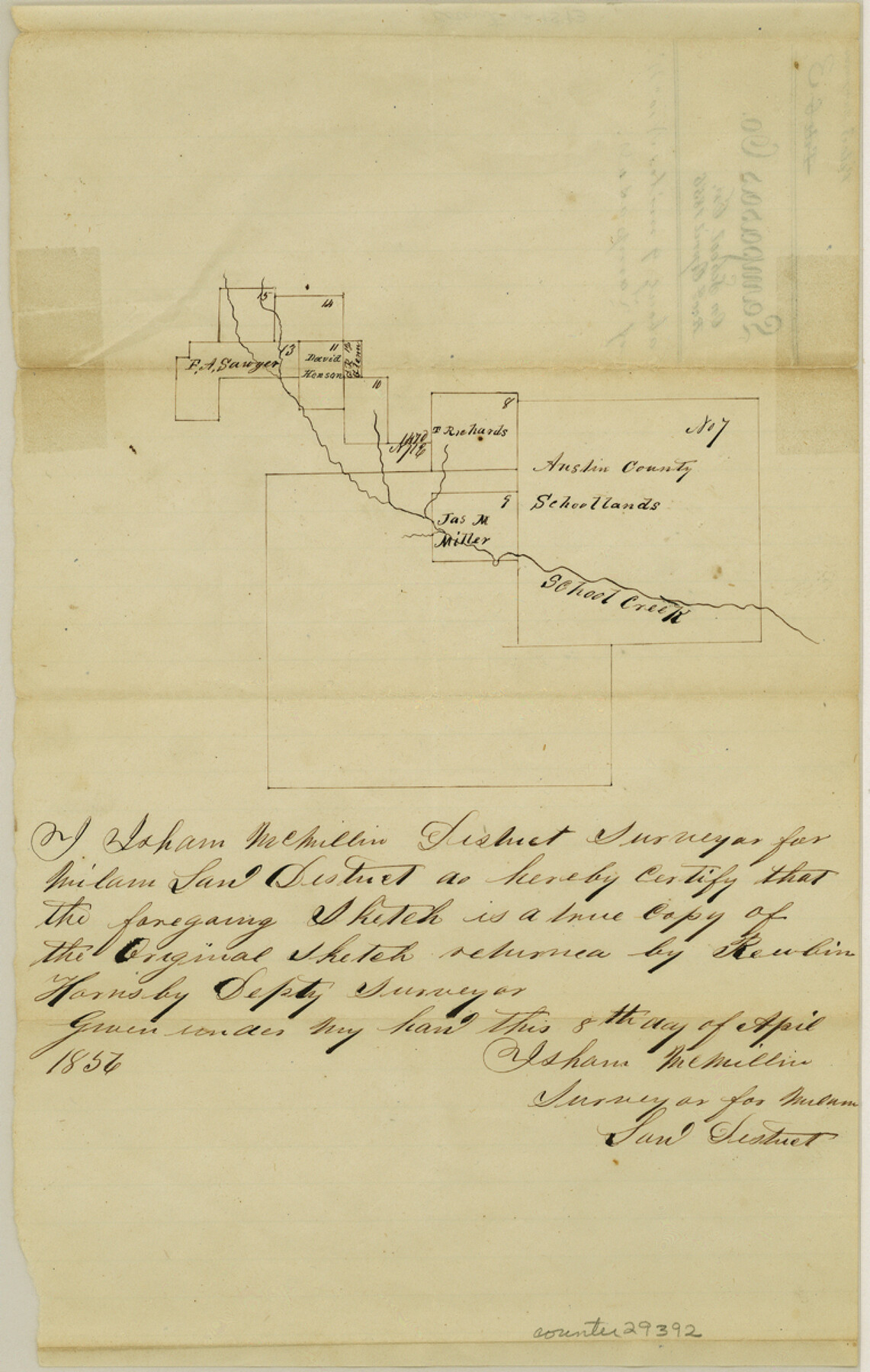
[Sketch of area north of Lampasas near School Creek]
-
Map/Doc
29392
-
Collection
General Map Collection
-
Object Dates
4/8/1856 (Creation Date)
-
People and Organizations
Isham McMillan (Surveyor/Engineer)
-
Counties
Lampasas
-
Subjects
Surveying Sketch File
-
Height x Width
12.1 x 7.6 inches
30.7 x 19.3 cm
-
Medium
paper, manuscript
-
Features
School Creek
School Creek
Part of: General Map Collection
Wilbarger County Working Sketch 19

Print $20.00
- Digital $50.00
Wilbarger County Working Sketch 19
1972
Size 36.6 x 38.3 inches
Map/Doc 72557
Kinney County Working Sketch 20

Print $20.00
- Digital $50.00
Kinney County Working Sketch 20
1948
Size 31.3 x 24.3 inches
Map/Doc 70202
Hudspeth County Sketch File 15

Print $9.00
- Digital $50.00
Hudspeth County Sketch File 15
1927
Size 14.3 x 8.8 inches
Map/Doc 26944
Map and Profile of the Denison and Pacific Railway from Denison to Whitesboro

Print $40.00
- Digital $50.00
Map and Profile of the Denison and Pacific Railway from Denison to Whitesboro
1878
Size 42.5 x 57.5 inches
Map/Doc 64284
Wilson County Sketch File 11

Print $27.00
- Digital $50.00
Wilson County Sketch File 11
Size 19.5 x 23.6 inches
Map/Doc 40419
Concho County Rolled Sketch 51

Print $20.00
- Digital $50.00
Concho County Rolled Sketch 51
1967
Size 31.0 x 25.5 inches
Map/Doc 5559
Borden County

Print $20.00
- Digital $50.00
Borden County
1892
Size 44.1 x 44.1 inches
Map/Doc 66717
Hill County Sketch File 21a

Print $4.00
- Digital $50.00
Hill County Sketch File 21a
1887
Size 10.8 x 8.4 inches
Map/Doc 26503
Kimble County Rolled Sketch 32

Print $20.00
- Digital $50.00
Kimble County Rolled Sketch 32
1973
Size 23.1 x 19.6 inches
Map/Doc 6522
Maps of Gulf Intracoastal Waterway, Texas - Sabine River to the Rio Grande and connecting waterways including ship channels

Print $20.00
- Digital $50.00
Maps of Gulf Intracoastal Waterway, Texas - Sabine River to the Rio Grande and connecting waterways including ship channels
1966
Size 14.5 x 22.2 inches
Map/Doc 61960
Hidalgo County Working Sketch 1

Print $20.00
- Digital $50.00
Hidalgo County Working Sketch 1
1939
Size 24.8 x 21.4 inches
Map/Doc 66178
McMullen County Working Sketch 43

Print $20.00
- Digital $50.00
McMullen County Working Sketch 43
1980
Size 35.2 x 28.1 inches
Map/Doc 70744
You may also like
Flight Mission No. CUG-3P, Frame 93, Kleberg County

Print $20.00
- Digital $50.00
Flight Mission No. CUG-3P, Frame 93, Kleberg County
1956
Size 18.5 x 22.2 inches
Map/Doc 86263
Amistad International Reservoir on Rio Grande Key Sheet

Print $20.00
- Digital $50.00
Amistad International Reservoir on Rio Grande Key Sheet
1960
Size 13.0 x 32.4 inches
Map/Doc 73345
J. De Cordova's Map of the State of Texas Compiled from the records of the General Land Office of the State

Print $20.00
- Digital $50.00
J. De Cordova's Map of the State of Texas Compiled from the records of the General Land Office of the State
1849
Size 33.9 x 32.1 inches
Map/Doc 7826
Flight Mission No. BRA-8M, Frame 84, Jefferson County

Print $20.00
- Digital $50.00
Flight Mission No. BRA-8M, Frame 84, Jefferson County
1953
Size 18.6 x 22.4 inches
Map/Doc 85604
Map of Kinney County

Print $20.00
- Digital $50.00
Map of Kinney County
1888
Size 27.5 x 26.1 inches
Map/Doc 3779
Real County Sketch File 18

Print $28.00
- Digital $50.00
Real County Sketch File 18
1964
Size 14.3 x 8.9 inches
Map/Doc 35076
Hydrographic Survey H-6395 of Outer Coast of Padre Island; Gulf of Mexico

Print $40.00
- Digital $50.00
Hydrographic Survey H-6395 of Outer Coast of Padre Island; Gulf of Mexico
1938
Size 55.1 x 33.3 inches
Map/Doc 2697

Taylor County Rolled Sketch 25

Print $20.00
- Digital $50.00
Taylor County Rolled Sketch 25
1962
Size 27.1 x 46.0 inches
Map/Doc 7917
Culberson County Rolled Sketch 29

Print $20.00
- Digital $50.00
Culberson County Rolled Sketch 29
Size 44.3 x 21.4 inches
Map/Doc 8745
Motley County Sketch File 20 (S)

Print $14.00
- Digital $50.00
Motley County Sketch File 20 (S)
Size 7.2 x 8.7 inches
Map/Doc 32196
Upton County Rolled Sketch 49-CF

Print $20.00
- Digital $50.00
Upton County Rolled Sketch 49-CF
1926
Size 44.9 x 32.4 inches
Map/Doc 76143