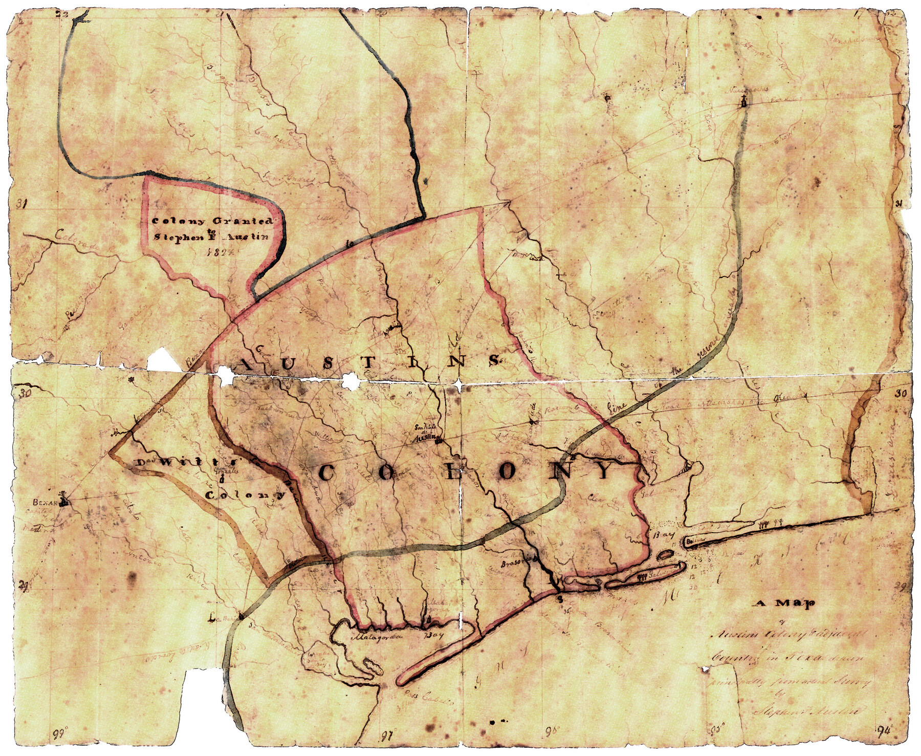
A Map of Austin's Colony and adjacent country in Texas drawn principally from actual survey by Stephen F. Austin
-
Map/Doc
93353
-
Collection
Non-GLO Digital Images
-
Object Dates
[1820-1829 ca.] (Creation Date)
7/26/2012 (File Date)
-
People and Organizations
Stephen F. Austin (Surveyor/Engineer)
-
Counties
Austin Wharton Fort Bend Matagorda Colorado
-
Subjects
Colony
-
Height x Width
13.8 x 17.0 inches
35.1 x 43.2 cm
-
Medium
digital image
-
Comments
Digital scan of original in DRT Library. Image provided here for research only. Duplication not available. Map shows Coastal/Border Reserve Line.
-
Features
Coastal/Border Reserve Line
Part of: Non-GLO Digital Images
Houston, Texas (Looking South)

Print $20.00
Houston, Texas (Looking South)
1891
Size 25.3 x 41.1 inches
Map/Doc 89094
Bird's Eye View of Gatesville, Coryell County, Texas

Print $20.00
Bird's Eye View of Gatesville, Coryell County, Texas
1884
Size 15.7 x 24.2 inches
Map/Doc 89088
Map of the State of Texas Engraved to Illustrate Mitchell's School and Family Geography

Print $20.00
Map of the State of Texas Engraved to Illustrate Mitchell's School and Family Geography
1846
Size 12.0 x 9.6 inches
Map/Doc 87902
Bird's Eye View of the City of San Antonio, Bexar County, Texas

Print $20.00
Bird's Eye View of the City of San Antonio, Bexar County, Texas
1873
Size 23.9 x 29.6 inches
Map/Doc 89203
Perspective Map of the City of Laredo, Texas, the Gateway to and from Mexico

Print $20.00
Perspective Map of the City of Laredo, Texas, the Gateway to and from Mexico
1892
Size 22.1 x 34.2 inches
Map/Doc 89098
Railroad Commissioner's Map of Texas

Print $20.00
Railroad Commissioner's Map of Texas
1897
Size 27.0 x 23.0 inches
Map/Doc 90070
Bird's Eye View of Bastrop, Bastrop County, Texas

Print $20.00
Bird's Eye View of Bastrop, Bastrop County, Texas
1887
Size 18.8 x 25.7 inches
Map/Doc 89073
Plan of the City of Washington the Capitol of the United States of America

Print $20.00
- Digital $50.00
Plan of the City of Washington the Capitol of the United States of America
1863
Size 12.7 x 15.8 inches
Map/Doc 94475
El Nuevo México y Tierras Adyacentes Levantado para la Demarcación de los Límites de los Dominios Españoles y de los Estados Unidos

El Nuevo México y Tierras Adyacentes Levantado para la Demarcación de los Límites de los Dominios Españoles y de los Estados Unidos
1811
Size 9.4 x 12.6 inches
Map/Doc 94445
Preliminary Survey of the Entrance to the Rio Grande, Texas

Print $20.00
Preliminary Survey of the Entrance to the Rio Grande, Texas
1854
Size 14.2 x 14.9 inches
Map/Doc 95283

A New Chart of the World on Mercator's Projection: Exhibiting the Tracks & Discoveries of the most Eminent Navigators, to the Present Period

Print $20.00
- Digital $50.00
A New Chart of the World on Mercator's Projection: Exhibiting the Tracks & Discoveries of the most Eminent Navigators, to the Present Period
1801
Size 20.0 x 22.4 inches
Map/Doc 97249
You may also like
Pecos County Sketch File 27

Print $20.00
- Digital $50.00
Pecos County Sketch File 27
1900
Size 18.1 x 14.5 inches
Map/Doc 12165
Anderson County Working Sketch 35

Print $20.00
- Digital $50.00
Anderson County Working Sketch 35
1968
Size 26.1 x 22.4 inches
Map/Doc 67035

Rusk County Sketch File 8

Print $4.00
Rusk County Sketch File 8
1856
Size 12.7 x 8.2 inches
Map/Doc 35503
Estes Quadrangle

Print $20.00
- Digital $50.00
Estes Quadrangle
1971
Size 27.8 x 23.6 inches
Map/Doc 73442
Dimmit County Working Sketch 9

Print $20.00
- Digital $50.00
Dimmit County Working Sketch 9
1934
Size 36.3 x 42.2 inches
Map/Doc 68670
[Surveys along the San Gabriel River]
![78375, [Surveys along the San Gabriel River], General Map Collection](https://historictexasmaps.com/wmedia_w700/maps/78375.tif.jpg)
Print $2.00
- Digital $50.00
[Surveys along the San Gabriel River]
Size 9.0 x 6.3 inches
Map/Doc 78375
[Southeast part of County near Jas. H. Price Survey]
![91888, [Southeast part of County near Jas. H. Price Survey], Twichell Survey Records](https://historictexasmaps.com/wmedia_w700/maps/91888-1.tif.jpg)
Print $20.00
- Digital $50.00
[Southeast part of County near Jas. H. Price Survey]
Size 19.3 x 19.3 inches
Map/Doc 91888
Crockett County Working Sketch 86

Print $20.00
- Digital $50.00
Crockett County Working Sketch 86
1976
Size 34.7 x 38.0 inches
Map/Doc 68419
Zapata County Working Sketch Graphic Index, Sheet 2 (Sketches 19 to Most Recent)

Print $40.00
- Digital $50.00
Zapata County Working Sketch Graphic Index, Sheet 2 (Sketches 19 to Most Recent)
1935
Size 55.6 x 41.5 inches
Map/Doc 76750
Brewster County Working Sketch 68

Print $20.00
- Digital $50.00
Brewster County Working Sketch 68
1958
Size 23.3 x 22.6 inches
Map/Doc 67669
Williamson County Sketch File 32

Print $6.00
- Digital $50.00
Williamson County Sketch File 32
1986
Size 11.3 x 8.5 inches
Map/Doc 40393