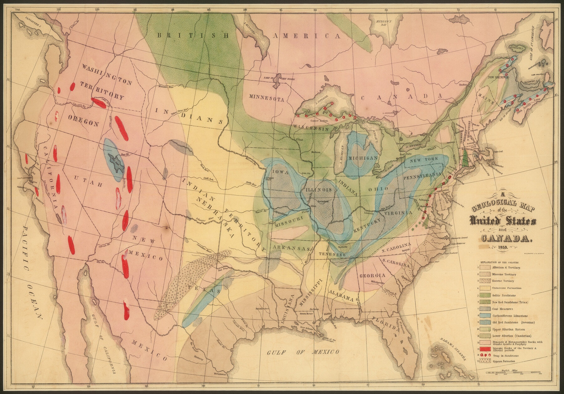
A Geological Map of the United States and Canada
-
Map/Doc
95189
-
Collection
Non-GLO Digital Images
-
Object Dates
1853 (Creation Date)
-
People and Organizations
W.C. Sharp (Printer)
[Edward Hitchcock] (Cartographer)
-
Subjects
United States
-
Height x Width
17.4 x 25.0 inches
44.2 x 63.5 cm
-
Medium
digital image
-
Comments
Digital image courtesy of an anonymous supporter of the Texas General Land Office in 2018.
Part of: Non-GLO Digital Images
A New Map of ye North Parts of America according to the division thereof by the Articles of Peace in 1763

Print $20.00
A New Map of ye North Parts of America according to the division thereof by the Articles of Peace in 1763
1763
Size 8.5 x 11.3 inches
Map/Doc 95280
Map of New York and Adjacent Cities

Print $20.00
- Digital $50.00
Map of New York and Adjacent Cities
1860
Size 17.8 x 28.7 inches
Map/Doc 94439
[Movements & Objectives of the 143rd & 144th Infantry on October 9-11, 1918, Appendix E, Nos.2 and 3]
![94131, [Movements & Objectives of the 143rd & 144th Infantry on October 9-11, 1918, Appendix E, Nos.2 and 3], Non-GLO Digital Images](https://historictexasmaps.com/wmedia_w700/maps/94131-1.tif.jpg)
Print $20.00
[Movements & Objectives of the 143rd & 144th Infantry on October 9-11, 1918, Appendix E, Nos.2 and 3]
1918
Size 41.6 x 19.9 inches
Map/Doc 94131
Greenville, Tex., County Seat of Hunt County

Print $20.00
Greenville, Tex., County Seat of Hunt County
1886
Size 17.3 x 24.9 inches
Map/Doc 89089
Bird's Eye View of New Braunfels, Comal County, Texas

Print $20.00
Bird's Eye View of New Braunfels, Comal County, Texas
1881
Size 17.0 x 24.1 inches
Map/Doc 89200
Mapa de los Estados Unidos de Méjico, Segun lo organizado y definido por las varias actas del Congreso de dicha Republica: y construido por las mejores autoridades

Print $20.00
Mapa de los Estados Unidos de Méjico, Segun lo organizado y definido por las varias actas del Congreso de dicha Republica: y construido por las mejores autoridades
1848
Size 31.1 x 43.0 inches
Map/Doc 93636
A general map of Great Britain and Ireland with part of Holland, Flanders, France & agreable to modern history

Print $20.00
A general map of Great Britain and Ireland with part of Holland, Flanders, France & agreable to modern history
1750
Size 21.6 x 25.7 inches
Map/Doc 97435
Bird's Eye View of San Marcos, Hays County, Texas

Print $20.00
Bird's Eye View of San Marcos, Hays County, Texas
1881
Size 18.5 x 28.3 inches
Map/Doc 89205
Plano de la Villa y Presidio de S. Antonio de Vejar situado en la Provincia de Tejas en 29 grad. y 52 minutos de latitud bor. y 275° y 57' de long. contados desde de Meridiano d. Tenerife

Plano de la Villa y Presidio de S. Antonio de Vejar situado en la Provincia de Tejas en 29 grad. y 52 minutos de latitud bor. y 275° y 57' de long. contados desde de Meridiano d. Tenerife
1768
Size 16.8 x 21.2 inches
Map/Doc 96564

[Divisional Boundary and Brigade Boundary on October 22, 1918, Appendix P]
![94125, [Divisional Boundary and Brigade Boundary on October 22, 1918, Appendix P], Non-GLO Digital Images](https://historictexasmaps.com/wmedia_w700/maps/94125-1.tif.jpg)
Print $20.00
[Divisional Boundary and Brigade Boundary on October 22, 1918, Appendix P]
1918
Size 16.2 x 16.7 inches
Map/Doc 94125
Perspective Map of the City of Laredo, Texas, the Gateway to and from Mexico

Print $20.00
Perspective Map of the City of Laredo, Texas, the Gateway to and from Mexico
1892
Size 22.1 x 34.2 inches
Map/Doc 89098
You may also like
Val Verde County Rolled Sketch 77

Print $20.00
- Digital $50.00
Val Verde County Rolled Sketch 77
1981
Size 36.2 x 37.4 inches
Map/Doc 10087
Marion County

Print $20.00
- Digital $50.00
Marion County
1943
Size 24.3 x 41.2 inches
Map/Doc 77365
Glasscock County Sketch File 18

Print $8.00
- Digital $50.00
Glasscock County Sketch File 18
1931
Size 9.7 x 6.2 inches
Map/Doc 24192
Haskell County

Print $20.00
- Digital $50.00
Haskell County
1933
Size 46.4 x 39.3 inches
Map/Doc 95525
J. W. Kendrick Land, Crosby County, Texas

Print $20.00
- Digital $50.00
J. W. Kendrick Land, Crosby County, Texas
Size 42.8 x 33.7 inches
Map/Doc 92603
Hopkins County Sketch File 3

Print $4.00
- Digital $50.00
Hopkins County Sketch File 3
Size 10.0 x 8.1 inches
Map/Doc 26685
Deaf Smith County, Texas / [Sec. 144, Blk. K-5]
![90623, Deaf Smith County, Texas / [Sec. 144, Blk. K-5], Twichell Survey Records](https://historictexasmaps.com/wmedia_w700/maps/90623-1.tif.jpg)
Print $20.00
- Digital $50.00
Deaf Smith County, Texas / [Sec. 144, Blk. K-5]
Size 22.9 x 22.8 inches
Map/Doc 90623
Traced from Genl. Arista's map captured by the American Army under Genl. Taylor at Resaca de la Palma 9th May '46 and presented to James K. Polk, President U. States

Print $20.00
- Digital $50.00
Traced from Genl. Arista's map captured by the American Army under Genl. Taylor at Resaca de la Palma 9th May '46 and presented to James K. Polk, President U. States
1846
Size 18.4 x 27.6 inches
Map/Doc 73059
Hudspeth County Sketch File 33

Print $6.00
- Digital $50.00
Hudspeth County Sketch File 33
1952
Size 11.3 x 8.8 inches
Map/Doc 26994
Victoria County Rolled Sketch 4A

Print $40.00
- Digital $50.00
Victoria County Rolled Sketch 4A
Size 66.4 x 43.9 inches
Map/Doc 10095
Mills County Sketch File 22

Print $4.00
- Digital $50.00
Mills County Sketch File 22
1882
Size 9.8 x 8.0 inches
Map/Doc 31670
Hispania Nova

Print $20.00
- Digital $50.00
Hispania Nova
1597
Size 12.0 x 14.9 inches
Map/Doc 94120