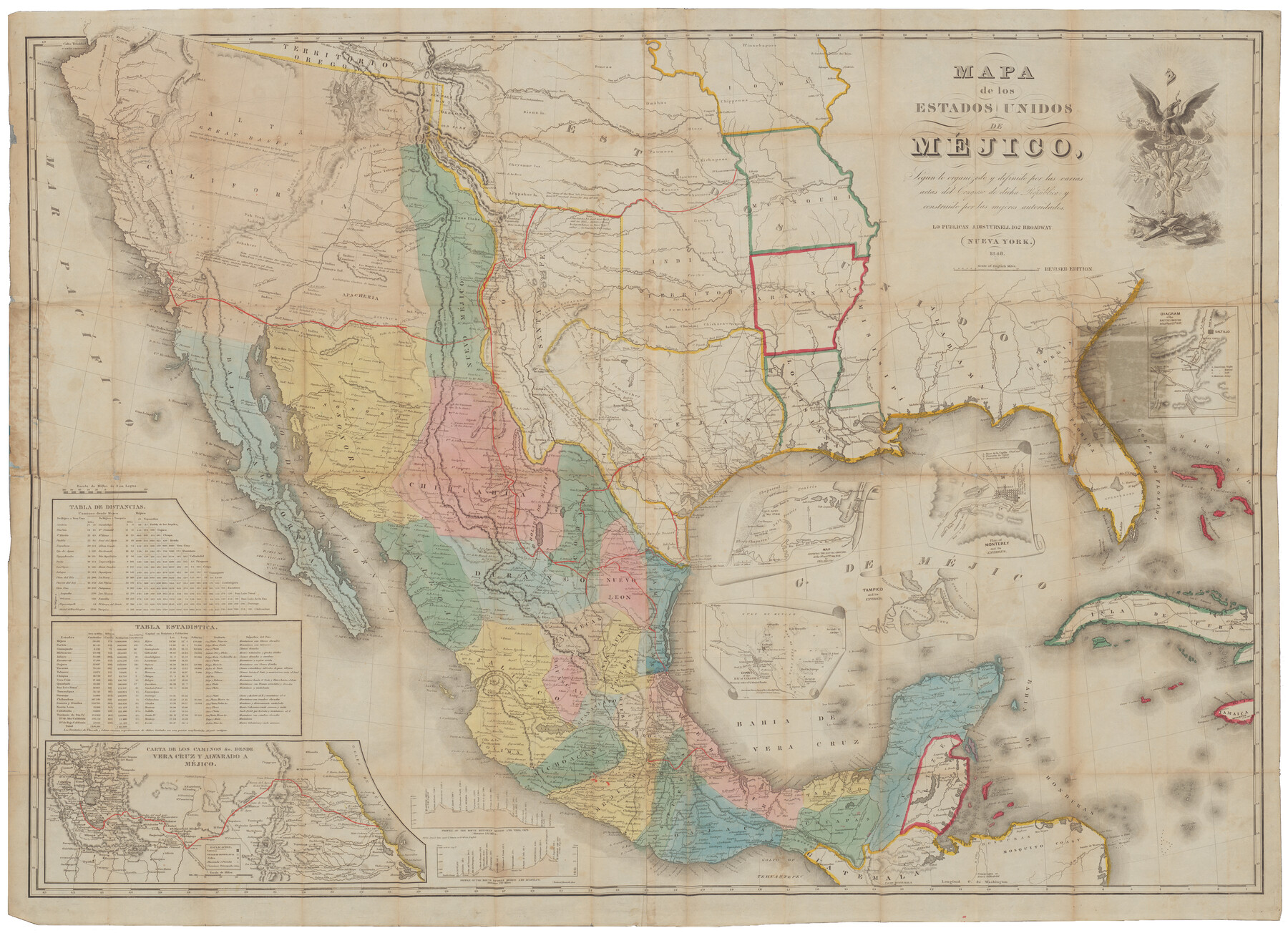
Mapa de los Estados Unidos de Méjico, Segun lo organizado y definido por las varias actas del Congreso de dicha Republica: y construido por las mejores autoridades
[Inset: Carta de los Caminos & c. desde Vera Cruz y Alvarado a Méjico]
-
Map/Doc
93636
-
Collection
Non-GLO Digital Images
-
Object Dates
1848 (Creation Date)
-
People and Organizations
J. Disturnell (Publisher)
J. Disturnell (Author)
-
Subjects
Mexico
-
Height x Width
31.1 x 43.0 inches
79.0 x 109.2 cm
-
Medium
digital image
-
Comments
This map was scanned for the benefit of the Texas State Historical Association courtesy of Mary Jon & J.P. Bryan's "Visions of the West" Collection.
Part of: Non-GLO Digital Images
Paris, Texas, County Seat of Lamar County

Print $20.00
Paris, Texas, County Seat of Lamar County
1885
Size 17.8 x 23.8 inches
Map/Doc 89201
Mapa original de Texas por el Ciudadano Estevan F. Austin Presentado al Excmo. Sr. Presidente, por su Autor

Mapa original de Texas por el Ciudadano Estevan F. Austin Presentado al Excmo. Sr. Presidente, por su Autor
1830
Size 31.6 x 25.4 inches
Map/Doc 94562
Perspective Map of Fort Worth, Tex.

Print $20.00
Perspective Map of Fort Worth, Tex.
1891
Size 19.9 x 33.0 inches
Map/Doc 89083

Bird's Eye View of Jefferson, Texas

Print $20.00
Bird's Eye View of Jefferson, Texas
1872
Size 18.7 x 23.5 inches
Map/Doc 89095
Waco, Tex., County Seat of McLennan Co.

Print $20.00
Waco, Tex., County Seat of McLennan Co.
1886
Size 23.1 x 32.7 inches
Map/Doc 89212
J. De Cordova's Map of the State of Texas Compiled from the records of the General Land Office of the State

Print $20.00
J. De Cordova's Map of the State of Texas Compiled from the records of the General Land Office of the State
1849
Size 35.7 x 33.6 inches
Map/Doc 93964
Map of the United States Exhibiting the grants of lands made by the general government to aid in the construction of railroads and wagon roads

Print $20.00
Map of the United States Exhibiting the grants of lands made by the general government to aid in the construction of railroads and wagon roads
1878
Size 20.8 x 29.4 inches
Map/Doc 95286
Perspective Map of the City of Laredo, Texas, the Gateway to and from Mexico

Print $20.00
Perspective Map of the City of Laredo, Texas, the Gateway to and from Mexico
1892
Size 22.1 x 34.2 inches
Map/Doc 89098
Bird's Eye View of the City of Houston, Texas

Print $20.00
Bird's Eye View of the City of Houston, Texas
1873
Size 24.0 x 30.9 inches
Map/Doc 89093

[WWI Topographic Planning Map of the Ardennes department] - Verso
![94130, [WWI Topographic Planning Map of the Ardennes department] - Verso, Non-GLO Digital Images](https://historictexasmaps.com/wmedia_w700/maps/94130-1.tif.jpg)
Print $20.00
[WWI Topographic Planning Map of the Ardennes department] - Verso
1918
Size 35.9 x 20.4 inches
Map/Doc 94130
You may also like
[Sketch highlighting Bob Reid and Fred Turner surveys]
![91692, [Sketch highlighting Bob Reid and Fred Turner surveys], Twichell Survey Records](https://historictexasmaps.com/wmedia_w700/maps/91692-1.tif.jpg)
Print $2.00
- Digital $50.00
[Sketch highlighting Bob Reid and Fred Turner surveys]
Size 5.9 x 7.6 inches
Map/Doc 91692
Burnet County Rolled Sketch 9

Print $40.00
- Digital $50.00
Burnet County Rolled Sketch 9
1971
Size 37.7 x 51.3 inches
Map/Doc 8545
Nueces County Sketch File 77a and 77b

Print $26.00
- Digital $50.00
Nueces County Sketch File 77a and 77b
1986
Size 11.1 x 8.6 inches
Map/Doc 33057
Mexico or New Spain in which the Motions of Cortes may be traced

Print $20.00
- Digital $50.00
Mexico or New Spain in which the Motions of Cortes may be traced
1795
Size 14.5 x 16.5 inches
Map/Doc 93650
Flight Mission No. BRE-1P, Frame 149, Nueces County

Print $20.00
- Digital $50.00
Flight Mission No. BRE-1P, Frame 149, Nueces County
1956
Size 18.3 x 22.3 inches
Map/Doc 86709
Reeves County Working Sketch 36

Print $20.00
- Digital $50.00
Reeves County Working Sketch 36
1970
Size 43.1 x 35.0 inches
Map/Doc 63479
Coast Chart No. 212 - From Latitude 26° 33' to the Rio Grande Texas

Print $20.00
- Digital $50.00
Coast Chart No. 212 - From Latitude 26° 33' to the Rio Grande Texas
1886
Size 27.7 x 18.2 inches
Map/Doc 72827
[G. H. & H. RR. Co. Block 5 and surrounding surveys]
![90877, [G. H. & H. RR. Co. Block 5 and surrounding surveys], Twichell Survey Records](https://historictexasmaps.com/wmedia_w700/maps/90877-2.tif.jpg)
Print $20.00
- Digital $50.00
[G. H. & H. RR. Co. Block 5 and surrounding surveys]
1901
Size 28.0 x 15.2 inches
Map/Doc 90877
Maverick County Rolled Sketch 20

Print $20.00
- Digital $50.00
Maverick County Rolled Sketch 20
Size 24.5 x 38.7 inches
Map/Doc 6712
Briscoe County Working Sketch Graphic Index

Print $20.00
- Digital $50.00
Briscoe County Working Sketch Graphic Index
1930
Size 43.8 x 37.4 inches
Map/Doc 76478
The Republic County of Liberty. Boundaries Defined, December 18, 1837

Print $20.00
The Republic County of Liberty. Boundaries Defined, December 18, 1837
2020
Size 19.9 x 21.7 inches
Map/Doc 96208
Duval County Sketch File 79

Print $46.00
- Digital $50.00
Duval County Sketch File 79
1925
Size 14.3 x 9.1 inches
Map/Doc 21469