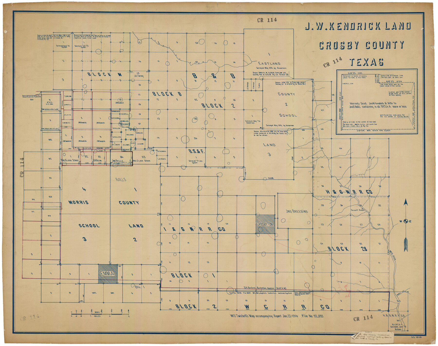
J. W. Kendrick Land, Crosby County, Texas
CR114
-
Map/Doc
92603
-
Collection
Twichell Survey Records
-
Counties
Crosby
-
Height x Width
42.8 x 33.7 inches
108.7 x 85.6 cm
Part of: Twichell Survey Records
[T.&P. Blocks 57 and 58, South to PSL Block 53]
![89763, [T.&P. Blocks 57 and 58, South to PSL Block 53], Twichell Survey Records](https://historictexasmaps.com/wmedia_w700/maps/89763-1.tif.jpg)
Print $40.00
- Digital $50.00
[T.&P. Blocks 57 and 58, South to PSL Block 53]
Size 30.5 x 68.7 inches
Map/Doc 89763
Working Sketch Reeves County [showing Blocks 70-72, C-8, 9, 17-18, and Texas & Pacific RR Block 58]
![91770, Working Sketch Reeves County [showing Blocks 70-72, C-8, 9, 17-18, and Texas & Pacific RR Block 58], Twichell Survey Records](https://historictexasmaps.com/wmedia_w700/maps/91770-1.tif.jpg)
Print $20.00
- Digital $50.00
Working Sketch Reeves County [showing Blocks 70-72, C-8, 9, 17-18, and Texas & Pacific RR Block 58]
1908
Size 21.6 x 17.2 inches
Map/Doc 91770
[Hockley, Lubbock, Terry and Lynn Corner]
![92954, [Hockley, Lubbock, Terry and Lynn Corner], Twichell Survey Records](https://historictexasmaps.com/wmedia_w700/maps/92954-1.tif.jpg)
Print $20.00
- Digital $50.00
[Hockley, Lubbock, Terry and Lynn Corner]
Size 24.5 x 18.9 inches
Map/Doc 92954
[Township 3 North, Block 34]
![91208, [Township 3 North, Block 34], Twichell Survey Records](https://historictexasmaps.com/wmedia_w700/maps/91208-1.tif.jpg)
Print $3.00
- Digital $50.00
[Township 3 North, Block 34]
Size 10.2 x 14.0 inches
Map/Doc 91208
[T. H. Jones Blk. O, Blk. F, Coyote Lake Area, Sutton County School Land Leagues]
![90246, [T. H. Jones Blk. O, Blk. F, Coyote Lake Area, Sutton County School Land Leagues], Twichell Survey Records](https://historictexasmaps.com/wmedia_w700/maps/90246-1.tif.jpg)
Print $20.00
- Digital $50.00
[T. H. Jones Blk. O, Blk. F, Coyote Lake Area, Sutton County School Land Leagues]
Size 21.0 x 33.6 inches
Map/Doc 90246
[Sketch of Randall County]
![91757, [Sketch of Randall County], Twichell Survey Records](https://historictexasmaps.com/wmedia_w700/maps/91757-1.tif.jpg)
Print $20.00
- Digital $50.00
[Sketch of Randall County]
Size 21.4 x 18.5 inches
Map/Doc 91757
[Skletch filed with corrected field notes of Surveys 27, 28, 29 and 30, Block B-19 Public School Lands]
![93056, [Skletch filed with corrected field notes of Surveys 27, 28, 29 and 30, Block B-19 Public School Lands], Twichell Survey Records](https://historictexasmaps.com/wmedia_w700/maps/93056-1.tif.jpg)
Print $20.00
- Digital $50.00
[Skletch filed with corrected field notes of Surveys 27, 28, 29 and 30, Block B-19 Public School Lands]
1943
Size 19.3 x 15.4 inches
Map/Doc 93056
Dr. S. C. Arnett Farm Part Section 22, Block JS

Print $20.00
- Digital $50.00
Dr. S. C. Arnett Farm Part Section 22, Block JS
Size 16.0 x 18.7 inches
Map/Doc 92306
[Pencil sketch showing area between sections 1102, 1101, 1111, and 1112 on the west and sections 3-6 on the east]
![90365, [Pencil sketch showing area between sections 1102, 1101, 1111, and 1112 on the west and sections 3-6 on the east], Twichell Survey Records](https://historictexasmaps.com/wmedia_w700/maps/90365-1.tif.jpg)
Print $2.00
- Digital $50.00
[Pencil sketch showing area between sections 1102, 1101, 1111, and 1112 on the west and sections 3-6 on the east]
Size 5.1 x 8.1 inches
Map/Doc 90365
[Central Part of San Miguel County]
![92038, [Central Part of San Miguel County], Twichell Survey Records](https://historictexasmaps.com/wmedia_w700/maps/92038-1.tif.jpg)
Print $20.00
- Digital $50.00
[Central Part of San Miguel County]
Size 19.5 x 16.8 inches
Map/Doc 92038
[Blocks T1, T2, T3, S3, A, 05, 02 and vicinity]
![92196, [Blocks T1, T2, T3, S3, A, 05, 02 and vicinity], Twichell Survey Records](https://historictexasmaps.com/wmedia_w700/maps/92196-1.tif.jpg)
Print $20.00
- Digital $50.00
[Blocks T1, T2, T3, S3, A, 05, 02 and vicinity]
Size 20.3 x 22.9 inches
Map/Doc 92196
[Block V and surrounding surveys]
![90292, [Block V and surrounding surveys], Twichell Survey Records](https://historictexasmaps.com/wmedia_w700/maps/90292-1.tif.jpg)
Print $3.00
- Digital $50.00
[Block V and surrounding surveys]
Size 11.9 x 12.5 inches
Map/Doc 90292
You may also like
Newton County Working Sketch 11

Print $20.00
- Digital $50.00
Newton County Working Sketch 11
1941
Size 22.7 x 23.5 inches
Map/Doc 71257
The Rand McNally New Commercial Atlas Map of Texas

Print $20.00
- Digital $50.00
The Rand McNally New Commercial Atlas Map of Texas
1915
Size 28.5 x 40.3 inches
Map/Doc 95862

Block 3, C. D. Elliston Addition

Print $20.00
- Digital $50.00
Block 3, C. D. Elliston Addition
1953
Size 14.8 x 18.3 inches
Map/Doc 92728
[I. & G. N. Block 1, sections 64, 65, 67-71 and 545 along river]
![91602, [I. & G. N. Block 1, sections 64, 65, 67-71 and 545 along river], Twichell Survey Records](https://historictexasmaps.com/wmedia_w700/maps/91602-1.tif.jpg)
Print $2.00
- Digital $50.00
[I. & G. N. Block 1, sections 64, 65, 67-71 and 545 along river]
Size 8.8 x 14.3 inches
Map/Doc 91602
Archer County Boundary File 3

Print $54.00
- Digital $50.00
Archer County Boundary File 3
Size 9.3 x 7.3 inches
Map/Doc 50094
Maverick County Sketch File 8

Print $8.00
- Digital $50.00
Maverick County Sketch File 8
1878
Size 11.5 x 6.5 inches
Map/Doc 31064
Flight Mission No. DQN-4K, Frame 3, Calhoun County

Print $20.00
- Digital $50.00
Flight Mission No. DQN-4K, Frame 3, Calhoun County
1953
Size 18.9 x 22.4 inches
Map/Doc 84368
Rusk County Rolled Sketch OBS

Print $20.00
- Digital $50.00
Rusk County Rolled Sketch OBS
1937
Size 26.3 x 21.8 inches
Map/Doc 7550
[Sketch of Part of B. S. & F. Block 9]
![93090, [Sketch of Part of B. S. & F. Block 9], Twichell Survey Records](https://historictexasmaps.com/wmedia_w700/maps/93090-1.tif.jpg)
Print $2.00
- Digital $50.00
[Sketch of Part of B. S. & F. Block 9]
Size 7.6 x 7.4 inches
Map/Doc 93090
Yoakum County Sketch File 5

Print $10.00
- Digital $50.00
Yoakum County Sketch File 5
1899
Size 14.3 x 9.0 inches
Map/Doc 40733
Travis County Appraisal District Plat Map 2_1709

Print $20.00
- Digital $50.00
Travis County Appraisal District Plat Map 2_1709
Size 21.6 x 26.5 inches
Map/Doc 94210