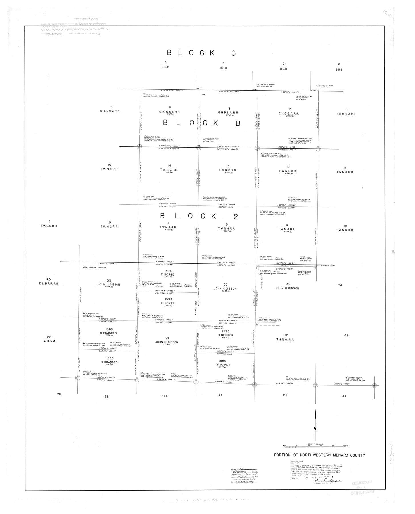
Menard County Rolled Sketch 10
Portion of northwestern Menard County
-
Map/Doc
9511
-
Collection
General Map Collection
-
Object Dates
1955/12/21 (Creation Date)
1956/2/1 (File Date)
-
People and Organizations
Byron L. Simpson (Surveyor/Engineer)
-
Counties
Menard
-
Subjects
Surveying Rolled Sketch
-
Height x Width
46.7 x 37.7 inches
118.6 x 95.8 cm
-
Scale
1" = 360 varas
-
Comments
See Menard County Sketch File 28 (31567) for report.
Related maps
Menard County Sketch File 28

Print $8.00
- Digital $50.00
Menard County Sketch File 28
1955
Size 11.0 x 8.6 inches
Map/Doc 31567
Part of: General Map Collection
Van Zandt County Sketch File 16 1/2

Print $4.00
- Digital $50.00
Van Zandt County Sketch File 16 1/2
1858
Size 11.0 x 7.8 inches
Map/Doc 39414
[Sketch for Mineral Application 24072, San Jacinto River]
![65587, [Sketch for Mineral Application 24072, San Jacinto River], General Map Collection](https://historictexasmaps.com/wmedia_w700/maps/65587.tif.jpg)
Print $20.00
- Digital $50.00
[Sketch for Mineral Application 24072, San Jacinto River]
1929
Size 19.3 x 16.4 inches
Map/Doc 65587
A New Map of North America

Print $20.00
- Digital $50.00
A New Map of North America
1779
Size 18.5 x 22.2 inches
Map/Doc 95141
Fannin County Sketch File 26

Print $4.00
- Digital $50.00
Fannin County Sketch File 26
1873
Size 8.5 x 10.3 inches
Map/Doc 22495
[Right of Way and Track Map, the Missouri, Kansas and Texas Ry. of Texas - Henrietta Division]
![64759, [Right of Way and Track Map, the Missouri, Kansas and Texas Ry. of Texas - Henrietta Division], General Map Collection](https://historictexasmaps.com/wmedia_w700/maps/64759.tif.jpg)
Print $20.00
- Digital $50.00
[Right of Way and Track Map, the Missouri, Kansas and Texas Ry. of Texas - Henrietta Division]
1918
Size 11.9 x 26.8 inches
Map/Doc 64759
Floyd County Working Sketch 3

Print $20.00
- Digital $50.00
Floyd County Working Sketch 3
1948
Size 27.4 x 22.8 inches
Map/Doc 69182
Jeff Davis County Working Sketch 31

Print $20.00
- Digital $50.00
Jeff Davis County Working Sketch 31
1969
Size 41.6 x 43.3 inches
Map/Doc 66526
Gaines County Rolled Sketch 12

Print $20.00
- Digital $50.00
Gaines County Rolled Sketch 12
1940
Size 26.6 x 33.8 inches
Map/Doc 5932
McCulloch County Sketch File 2

Print $4.00
- Digital $50.00
McCulloch County Sketch File 2
1872
Size 12.8 x 8.1 inches
Map/Doc 31167
Jefferson County NRC Article 33.136 Sketch 6

Print $4.00
- Digital $50.00
Jefferson County NRC Article 33.136 Sketch 6
2005
Size 14.1 x 8.6 inches
Map/Doc 83171
Newton County Rolled Sketch 11

Print $20.00
- Digital $50.00
Newton County Rolled Sketch 11
1951
Size 15.5 x 46.1 inches
Map/Doc 9576
Childress County Sketch File 17a

Print $96.00
- Digital $50.00
Childress County Sketch File 17a
Size 12.4 x 8.6 inches
Map/Doc 18316
You may also like
Padre Island National Seashore, Texas - Dependent Resurvey

Print $4.00
- Digital $50.00
Padre Island National Seashore, Texas - Dependent Resurvey
2001
Size 18.4 x 24.0 inches
Map/Doc 60551
Texas Gulf Coast Map from the Sabine River to the Rio Grande as subdivided for mineral development

Print $40.00
- Digital $50.00
Texas Gulf Coast Map from the Sabine River to the Rio Grande as subdivided for mineral development
Size 46.0 x 91.3 inches
Map/Doc 2901
[Southeast part of County near Jas. H. Price Survey]
![91888, [Southeast part of County near Jas. H. Price Survey], Twichell Survey Records](https://historictexasmaps.com/wmedia_w700/maps/91888-1.tif.jpg)
Print $20.00
- Digital $50.00
[Southeast part of County near Jas. H. Price Survey]
Size 19.3 x 19.3 inches
Map/Doc 91888
Palo Pinto County Sketch File 24

Print $20.00
- Digital $50.00
Palo Pinto County Sketch File 24
Size 21.0 x 32.8 inches
Map/Doc 12136
Bowie County Working Sketch 11

Print $20.00
- Digital $50.00
Bowie County Working Sketch 11
1958
Size 43.2 x 31.6 inches
Map/Doc 67415
United States - Gulf Coast - From Latitude 26° 33' to the Rio Grande Texas

Print $20.00
- Digital $50.00
United States - Gulf Coast - From Latitude 26° 33' to the Rio Grande Texas
1918
Size 27.7 x 18.2 inches
Map/Doc 72850
Seminole Cemetery, Gaines County, Texas

Print $20.00
- Digital $50.00
Seminole Cemetery, Gaines County, Texas
Size 29.2 x 31.7 inches
Map/Doc 92690
Upton County Rolled Sketch 57

Print $20.00
- Digital $50.00
Upton County Rolled Sketch 57
Size 30.1 x 41.8 inches
Map/Doc 8090
Right of Way and Track Map International & Gt. Northern Ry. operated by the International & Gt. Northern Ry. Co., Columbia Branch, Gulf Division

Print $40.00
- Digital $50.00
Right of Way and Track Map International & Gt. Northern Ry. operated by the International & Gt. Northern Ry. Co., Columbia Branch, Gulf Division
1917
Size 25.0 x 56.8 inches
Map/Doc 64599
Terrell County Working Sketch 70

Print $20.00
- Digital $50.00
Terrell County Working Sketch 70
1979
Size 39.0 x 36.5 inches
Map/Doc 69591
Jones County Working Sketch 10

Print $20.00
- Digital $50.00
Jones County Working Sketch 10
1982
Size 19.3 x 34.3 inches
Map/Doc 66648
Baylor County Sketch File 3

Print $4.00
- Digital $50.00
Baylor County Sketch File 3
1856
Size 12.4 x 8.5 inches
Map/Doc 14124