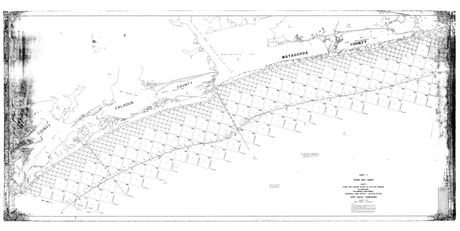
Texas Gulf Coast Map from the Sabine River to the Rio Grande as subdivided for mineral development
K-3-35; K-3-36; K-3-37; K-3-38
-
Map/Doc
2901
-
Collection
General Map Collection
-
People and Organizations
General Land Office (Publisher)
-
Counties
Matagorda Calhoun Aransas
-
Subjects
Energy Offshore Submerged Area
-
Height x Width
46.0 x 91.3 inches
116.8 x 231.9 cm
-
Comments
Obsolete as of 1967.
Part of: General Map Collection
Brazoria County Working Sketch 31

Print $20.00
- Digital $50.00
Brazoria County Working Sketch 31
1977
Size 26.3 x 31.7 inches
Map/Doc 67516
Hays County Working Sketch 19

Print $20.00
- Digital $50.00
Hays County Working Sketch 19
1980
Size 30.1 x 26.0 inches
Map/Doc 66093
Flight Mission No. DQO-2K, Frame 137, Galveston County

Print $20.00
- Digital $50.00
Flight Mission No. DQO-2K, Frame 137, Galveston County
1952
Size 18.8 x 22.5 inches
Map/Doc 85034
Crockett County Sketch File 8 (1)

Print $6.00
- Digital $50.00
Crockett County Sketch File 8 (1)
1858
Size 9.8 x 4.6 inches
Map/Doc 19652
A Chart of the Internal Part of Louisiana

Print $20.00
- Digital $50.00
A Chart of the Internal Part of Louisiana
1810
Size 19.0 x 17.3 inches
Map/Doc 95155
Howard County Boundary File 2c

Print $44.00
- Digital $50.00
Howard County Boundary File 2c
Size 5.0 x 8.9 inches
Map/Doc 55126
Map of Motley County

Print $20.00
- Digital $50.00
Map of Motley County
1902
Size 43.4 x 37.7 inches
Map/Doc 10799
Runnels County Sketch File 10

Print $46.00
Runnels County Sketch File 10
1882
Size 7.3 x 8.2 inches
Map/Doc 35445
Map of Brazos County, Texas

Print $40.00
- Digital $50.00
Map of Brazos County, Texas
1926
Size 89.6 x 55.1 inches
Map/Doc 93648
Jackson County Working Sketch 9

Print $20.00
- Digital $50.00
Jackson County Working Sketch 9
1982
Size 13.3 x 31.4 inches
Map/Doc 66457
General Chart of the Coast No. XXI Gulf Coast from Galveston to the Rio Grande

Print $20.00
- Digital $50.00
General Chart of the Coast No. XXI Gulf Coast from Galveston to the Rio Grande
1883
Size 27.1 x 18.4 inches
Map/Doc 72729
Runnels County Sketch File 6

Print $5.00
Runnels County Sketch File 6
1872
Size 9.9 x 15.9 inches
Map/Doc 35440
You may also like
Louisiana and Texas Intracoastal Waterway

Print $20.00
- Digital $50.00
Louisiana and Texas Intracoastal Waterway
1929
Size 13.8 x 19.9 inches
Map/Doc 83341
Jim Wells County Sketch File 2

Print $6.00
- Digital $50.00
Jim Wells County Sketch File 2
1931
Size 11.1 x 8.7 inches
Map/Doc 28424
Flight Mission No. DAG-24K, Frame 52, Matagorda County

Print $20.00
- Digital $50.00
Flight Mission No. DAG-24K, Frame 52, Matagorda County
1953
Size 17.0 x 15.8 inches
Map/Doc 86539
Vehlein and Company Empresario Colony. December 21, 1826

Print $20.00
Vehlein and Company Empresario Colony. December 21, 1826
2020
Size 20.8 x 21.7 inches
Map/Doc 96007
Harris County Working Sketch 29

Print $20.00
- Digital $50.00
Harris County Working Sketch 29
1934
Size 22.6 x 30.5 inches
Map/Doc 65921
General Highway Map, El Paso County, Texas

Print $20.00
General Highway Map, El Paso County, Texas
1961
Size 18.2 x 24.8 inches
Map/Doc 79458
Padre Island National Seashore, Texas - Dependent Resurvey

Print $4.00
- Digital $50.00
Padre Island National Seashore, Texas - Dependent Resurvey
2001
Size 18.3 x 24.2 inches
Map/Doc 60546
Wichita County Rolled Sketch 18

Print $20.00
- Digital $50.00
Wichita County Rolled Sketch 18
1923
Size 25.7 x 38.0 inches
Map/Doc 8254
Nueces County Rolled Sketch 3
Print $20.00
- Digital $50.00
Nueces County Rolled Sketch 3
1907
Size 17.3 x 34.2 inches
Map/Doc 6866
Gonzales County Working Sketch 14

Print $20.00
- Digital $50.00
Gonzales County Working Sketch 14
1981
Size 18.3 x 20.9 inches
Map/Doc 63230
Nueces County Rolled Sketch 115

Print $215.00
Nueces County Rolled Sketch 115
1992
Size 24.2 x 35.2 inches
Map/Doc 7126
Denton County Sketch File 22

Print $4.00
- Digital $50.00
Denton County Sketch File 22
1872
Size 8.5 x 16.0 inches
Map/Doc 20746