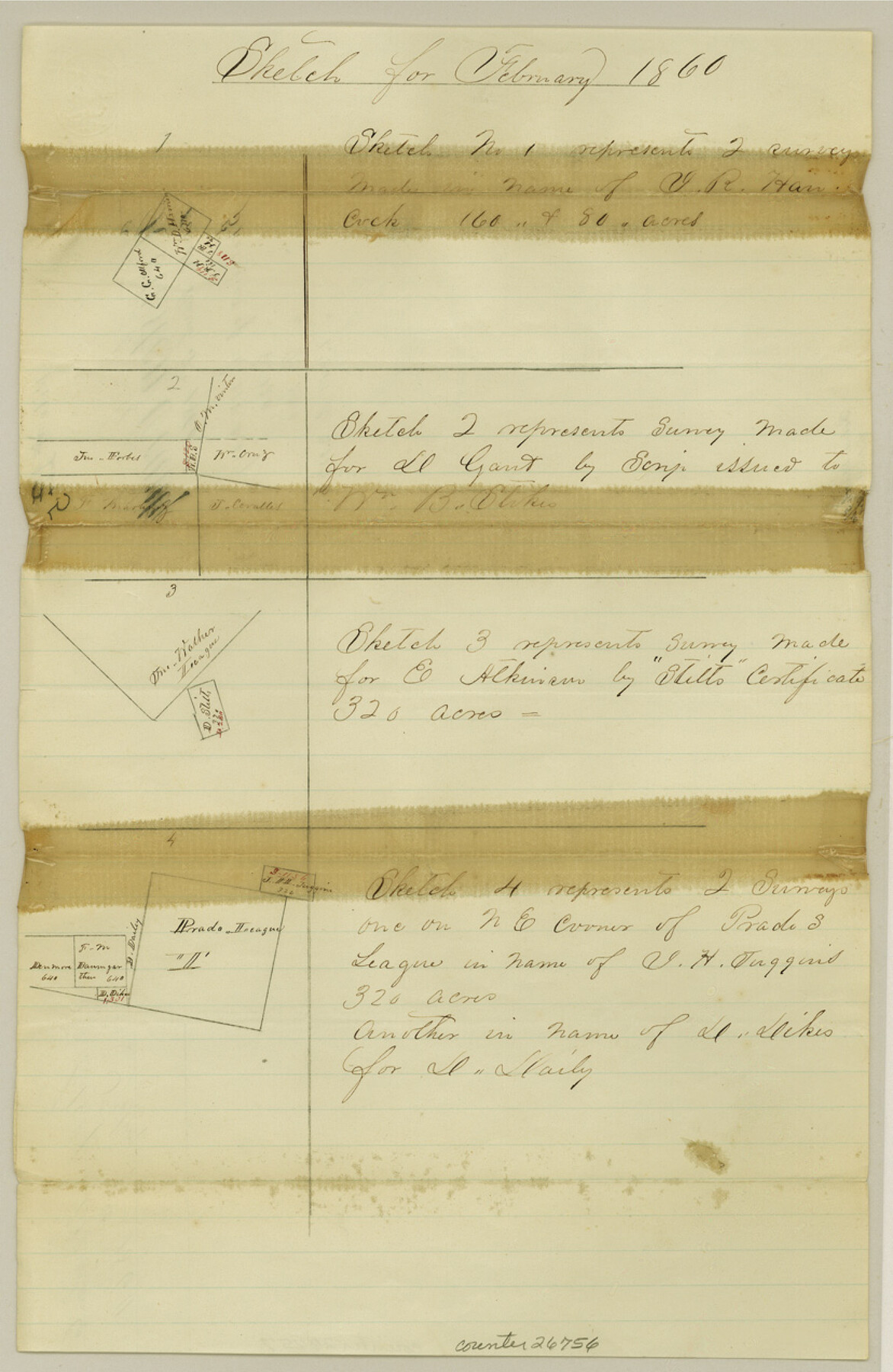
Houston County Sketch File 5
[Four sketches in various parts of county]
-
Map/Doc
26757
-
Collection
General Map Collection
-
Object Dates
3/5/1860 (File Date)
2/1/1860 (Creation Date)
-
People and Organizations
Charles Stokes (Surveyor/Engineer)
-
Counties
Houston
-
Subjects
Surveying Sketch File
-
Height x Width
8.5 x 12.7 inches
21.6 x 32.3 cm
-
Medium
paper, manuscript
Part of: General Map Collection
Irion County Sketch File 18

Print $10.00
- Digital $50.00
Irion County Sketch File 18
Size 11.2 x 8.7 inches
Map/Doc 27494
Dickens County Sketch File B

Print $4.00
- Digital $50.00
Dickens County Sketch File B
1894
Size 14.2 x 8.8 inches
Map/Doc 20831
Galveston County Rolled Sketch 44

Print $20.00
- Digital $50.00
Galveston County Rolled Sketch 44
1992
Size 30.6 x 23.7 inches
Map/Doc 5977
Pecos County Sketch File 104

Print $36.00
- Digital $50.00
Pecos County Sketch File 104
1966
Size 11.3 x 8.7 inches
Map/Doc 34020
North Part Brewster Co.

Print $40.00
- Digital $50.00
North Part Brewster Co.
1914
Size 40.4 x 49.3 inches
Map/Doc 66732
Crockett County Working Sketch 33

Print $20.00
- Digital $50.00
Crockett County Working Sketch 33
1926
Size 27.0 x 32.8 inches
Map/Doc 68366
Liberty County Working Sketch 44

Print $20.00
- Digital $50.00
Liberty County Working Sketch 44
1953
Size 21.3 x 30.2 inches
Map/Doc 70503
Jeff Davis County Rolled Sketch 1

Print $20.00
- Digital $50.00
Jeff Davis County Rolled Sketch 1
1882
Size 23.0 x 43.2 inches
Map/Doc 6359
McLennan County Sketch File 1

Print $4.00
- Digital $50.00
McLennan County Sketch File 1
Size 11.5 x 8.4 inches
Map/Doc 31224
Stonewall County Sketch File 9

Print $10.00
- Digital $50.00
Stonewall County Sketch File 9
Size 8.1 x 7.9 inches
Map/Doc 37227
Dawson County Rolled Sketch 7

Print $20.00
- Digital $50.00
Dawson County Rolled Sketch 7
Size 18.5 x 39.3 inches
Map/Doc 5692
Northwest Part of Webb County

Print $40.00
- Digital $50.00
Northwest Part of Webb County
1984
Size 42.6 x 52.2 inches
Map/Doc 73319
You may also like
Fort Bend County Working Sketch 14

Print $20.00
- Digital $50.00
Fort Bend County Working Sketch 14
1948
Size 37.4 x 32.7 inches
Map/Doc 69220
Fractional Township No. 10 South Range No. 9 East of the Indian Meridian, Indian Territory

Print $20.00
- Digital $50.00
Fractional Township No. 10 South Range No. 9 East of the Indian Meridian, Indian Territory
1898
Size 19.3 x 24.4 inches
Map/Doc 75217
Sterling County Sketch File 27

Print $40.00
- Digital $50.00
Sterling County Sketch File 27
1858
Size 8.0 x 9.2 inches
Map/Doc 82527
Baylor County Working Sketch 14

Print $40.00
- Digital $50.00
Baylor County Working Sketch 14
1982
Size 33.5 x 55.1 inches
Map/Doc 67299
Gonzales County

Print $20.00
- Digital $50.00
Gonzales County
1880
Size 25.3 x 22.6 inches
Map/Doc 3594
Bosque County

Print $40.00
- Digital $50.00
Bosque County
1945
Size 48.8 x 38.7 inches
Map/Doc 95432

Lamar County Sketch File 3

Print $6.00
- Digital $50.00
Lamar County Sketch File 3
1864
Size 14.2 x 8.6 inches
Map/Doc 29275
Flight Mission No. BRA-16M, Frame 106, Jefferson County

Print $20.00
- Digital $50.00
Flight Mission No. BRA-16M, Frame 106, Jefferson County
1953
Size 18.6 x 22.3 inches
Map/Doc 85718
Bowie County Sketch File A

Print $40.00
- Digital $50.00
Bowie County Sketch File A
1902
Size 15.6 x 27.3 inches
Map/Doc 10946
Howard County Working Sketch 7b

Print $40.00
- Digital $50.00
Howard County Working Sketch 7b
1950
Size 83.3 x 25.6 inches
Map/Doc 66274
Crosby County Working Sketch 13

Print $20.00
- Digital $50.00
Crosby County Working Sketch 13
1963
Size 17.9 x 30.7 inches
Map/Doc 68447