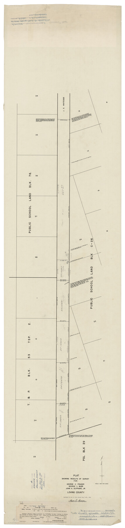
Loving County Rolled Sketch 4
Plat showing results of survey for George C. Fraser, George L. Burr, John K. Olyphant, Jr., Loving County
- 
                          Map/Doc
9465
 - 
                            Collection
General Map Collection
 - 
                            Object Dates
1952/5/26 (Creation Date)
1953/1/2 (File Date)
 - 
                            People and Organizations
Byron L. Simpson (Surveyor/Engineer)
 - 
                            Counties
Loving
 - 
                            Subjects
Surveying Rolled Sketch
 - 
                            Height x Width
82.2 x 19.5 inches
208.8 x 49.5 cm
 - 
                            Medium
linen, manuscript
 - 
                            Scale
1" = 300 varas
 
Part of: General Map Collection
            United States including territories and insular possessions showing the extent of public surveys, national parks, national forests, indian reservations, national wildlife refuges, and reclamation projects


                                            Print $40.00                    
                                             -                         Digital $50.00                                    
                United States including territories and insular possessions showing the extent of public surveys, national parks, national forests, indian reservations, national wildlife refuges, and reclamation projects
1953
Size 64.5 x 44.5 inches
                                Map/Doc 65795
            
            Cameron County NRC Article 33.136 Location Key Sheet


                                            Print $20.00                    
                                             -                         Digital $50.00                                    
                Cameron County NRC Article 33.136 Location Key Sheet
1983
Size 27.0 x 22.0 inches
                                Map/Doc 77013
            
            [Surveys between the Sabine and Red Rivers made for titles under Radford Berry, Commissioner]


                                            Print $20.00                    
                                             -                         Digital $50.00                                    
                [Surveys between the Sabine and Red Rivers made for titles under Radford Berry, Commissioner]
1835
Size 22.3 x 15.9 inches
                                Map/Doc 14
            
            Henderson County


                                            Print $40.00                    
                                             -                         Digital $50.00                                    
                Henderson County
1922
Size 33.0 x 62.7 inches
                                Map/Doc 66861
            
            Angelina County Working Sketch 21


                                            Print $20.00                    
                                             -                         Digital $50.00                                    
                Angelina County Working Sketch 21
1947
Size 35.7 x 35.8 inches
                                Map/Doc 67102
            
            Louisiana and Texas Intracoastal Waterway Proposed Extension to Rio Grande Valley


                                            Print $20.00                    
                                             -                         Digital $50.00                                    
                Louisiana and Texas Intracoastal Waterway Proposed Extension to Rio Grande Valley
1941
Size 28.1 x 41.1 inches
                                Map/Doc 61891
            
            [Right of Way & Track Map, The Texas & Pacific Ry. Co. Main Line]


                                            Print $20.00                    
                                             -                         Digital $50.00                                    
                [Right of Way & Track Map, The Texas & Pacific Ry. Co. Main Line]
Size 11.0 x 19.0 inches
                                Map/Doc 64688
            
            Stonewall County


                                            Print $20.00                    
                                             -                         Digital $50.00                                    
                Stonewall County
1879
Size 22.7 x 19.1 inches
                                Map/Doc 4058
            
            [Location Survey of the Southern Kansas Railway, Kiowa Extension from a point in Drake's Location, in Indian Territory 100 miles from south line of Kansas, continuing up Wolf Creek and South Canadian River to Cottonwood Creek in Hutchinson County]


                                            Print $20.00                    
                                             -                         Digital $50.00                                    
                [Location Survey of the Southern Kansas Railway, Kiowa Extension from a point in Drake's Location, in Indian Territory 100 miles from south line of Kansas, continuing up Wolf Creek and South Canadian River to Cottonwood Creek in Hutchinson County]
1886
Size 37.5 x 36.0 inches
                                Map/Doc 88845
            
            Pecos County Rolled Sketch 190


                                            Print $20.00                    
                                             -                         Digital $50.00                                    
                Pecos County Rolled Sketch 190
2005
Size 20.3 x 26.1 inches
                                Map/Doc 83284
            
            Map of Fisher and Miller's Colony made from the records in the Office of the District Surveyor of Bexar comprising also all the recent surveys


                                            Print $20.00                    
                                             -                         Digital $50.00                                    
                Map of Fisher and Miller's Colony made from the records in the Office of the District Surveyor of Bexar comprising also all the recent surveys
1855
Size 23.7 x 35.2 inches
                                Map/Doc 1971
            
            Lamb County Boundary File 1e


                                            Print $10.00                    
                                             -                         Digital $50.00                                    
                Lamb County Boundary File 1e
Size 11.3 x 8.8 inches
                                Map/Doc 56053
            You may also like
            C. B. Livestock Co.'s West-Ranch, Bailey County, Texas


                                            Print $2.00                    
                                             -                         Digital $50.00                                    
                C. B. Livestock Co.'s West-Ranch, Bailey County, Texas
Size 8.8 x 11.6 inches
                                Map/Doc 90383
            
            Map of Dallas County


                                            Print $20.00                    
                                             -                         Digital $50.00                                    
                Map of Dallas County
1871
Size 22.1 x 18.7 inches
                                Map/Doc 3463
            
            Limestone County Working Sketch 12


                                            Print $20.00                    
                                             -                         Digital $50.00                                    
                Limestone County Working Sketch 12
1922
Size 18.5 x 12.8 inches
                                Map/Doc 70562
            
            General Highway Map, Nueces County, Texas


                                            Print $20.00                    
                                    
                General Highway Map, Nueces County, Texas
1940
Size 24.6 x 18.4 inches
                                Map/Doc 79210
            
            Flight Mission No. DQN-5K, Frame 33, Calhoun County


                                            Print $20.00                    
                                             -                         Digital $50.00                                    
                Flight Mission No. DQN-5K, Frame 33, Calhoun County
1953
Size 18.5 x 22.3 inches
                                Map/Doc 84384
            
            Coryell County Working Sketch 9


                                            Print $20.00                    
                                             -                         Digital $50.00                                    
                Coryell County Working Sketch 9
1947
Size 28.7 x 30.0 inches
                                Map/Doc 68216
            
            Zapata County Rolled Sketch 12B


                                            Print $40.00                    
                                             -                         Digital $50.00                                    
                Zapata County Rolled Sketch 12B
1917
Size 55.7 x 40.0 inches
                                Map/Doc 10166
            
            Harris County Working Sketch 65


                                            Print $20.00                    
                                             -                         Digital $50.00                                    
                Harris County Working Sketch 65
1955
Size 29.5 x 28.6 inches
                                Map/Doc 65957
            
            Flight Mission No. DIX-8P, Frame 88, Aransas County


                                            Print $20.00                    
                                             -                         Digital $50.00                                    
                Flight Mission No. DIX-8P, Frame 88, Aransas County
1956
Size 18.6 x 22.3 inches
                                Map/Doc 83913
            
            Knox County Sketch File 30


                                            Print $15.00                    
                                             -                         Digital $50.00                                    
                Knox County Sketch File 30
1904
Size 8.2 x 5.2 inches
                                Map/Doc 29264
            
            Flight Mission No. CUG-1P, Frame 109, Kleberg County


                                            Print $20.00                    
                                             -                         Digital $50.00                                    
                Flight Mission No. CUG-1P, Frame 109, Kleberg County
1956
Size 18.6 x 22.3 inches
                                Map/Doc 86159
            
            Guadalupe County Working Sketch 9


                                            Print $20.00                    
                                             -                         Digital $50.00                                    
                Guadalupe County Working Sketch 9
1955
Size 21.9 x 12.6 inches
                                Map/Doc 63318