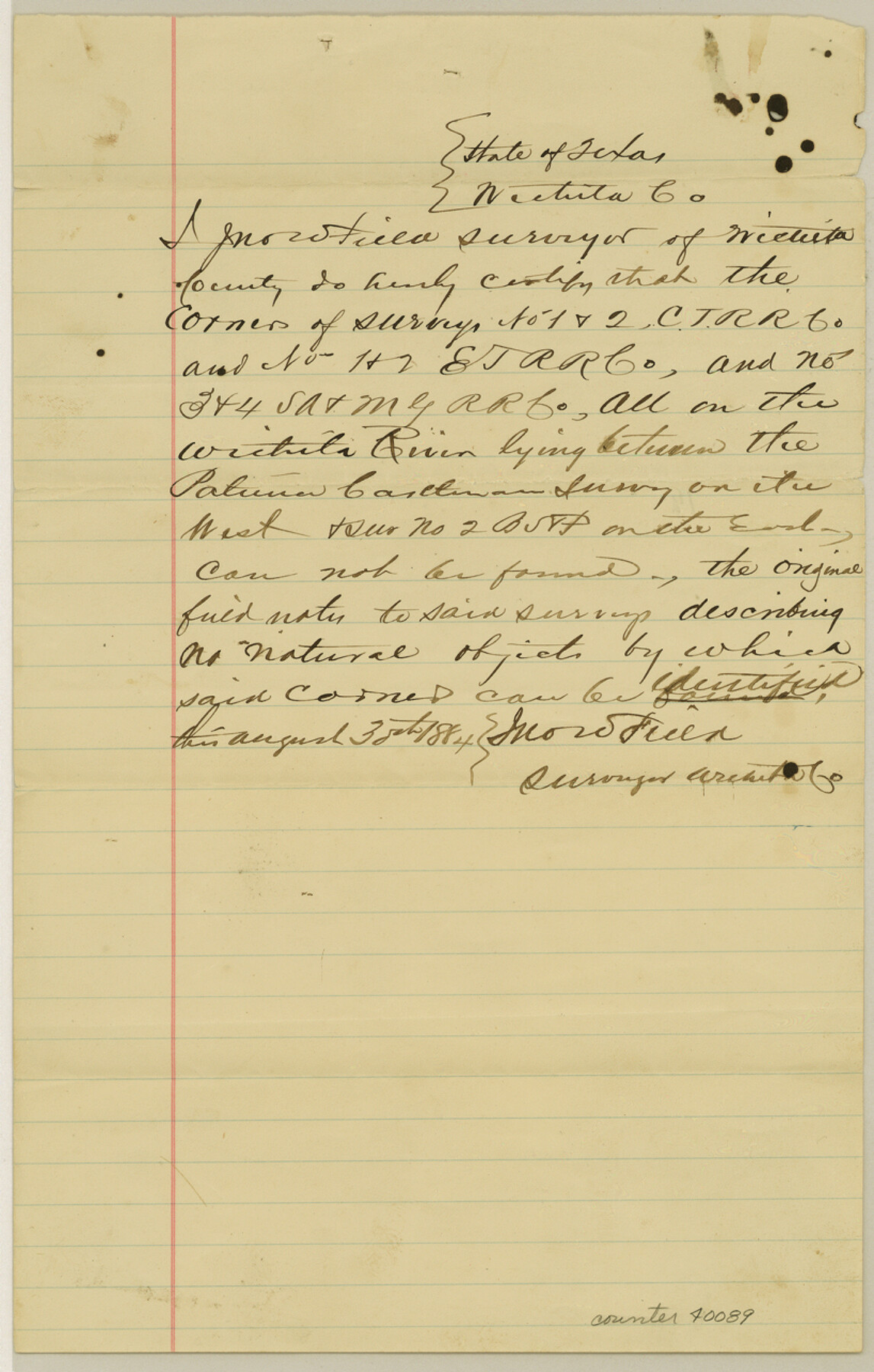
Wichita County Sketch File H
[Certificate as to the non-existence of corners]
-
Map/Doc
40089
-
Collection
General Map Collection
-
Object Dates
8/30/1884 (Creation Date)
-
People and Organizations
J.W. Fields (Surveyor/Engineer)
-
Counties
Wichita
-
Subjects
Surveying Sketch File
-
Height x Width
12.8 x 8.2 inches
32.5 x 20.8 cm
-
Medium
paper, manuscript
-
Features
Wichita River
Part of: General Map Collection
Controlled Mosaic by Jack Amman Photogrammetric Engineers, Inc - Sheet 42

Print $20.00
- Digital $50.00
Controlled Mosaic by Jack Amman Photogrammetric Engineers, Inc - Sheet 42
1954
Size 20.0 x 24.0 inches
Map/Doc 83499
Andrews County Sketch File 15

Print $24.00
- Digital $50.00
Andrews County Sketch File 15
Size 11.2 x 8.9 inches
Map/Doc 12887
Leon County Working Sketch 53

Print $20.00
- Digital $50.00
Leon County Working Sketch 53
1982
Size 22.3 x 25.4 inches
Map/Doc 70453
Bee County Sketch File 9

Print $4.00
- Digital $50.00
Bee County Sketch File 9
Size 8.1 x 10.2 inches
Map/Doc 14289
Map of Franklin County

Print $20.00
- Digital $50.00
Map of Franklin County
1879
Size 21.1 x 10.4 inches
Map/Doc 3560
Kimble County Working Sketch 27

Print $20.00
- Digital $50.00
Kimble County Working Sketch 27
1934
Size 16.1 x 17.3 inches
Map/Doc 70095

Calhoun County Rolled Sketch 20

Print $20.00
- Digital $50.00
Calhoun County Rolled Sketch 20
1959
Size 36.9 x 20.7 inches
Map/Doc 5372
Washington County Working Sketch 1

Print $20.00
- Digital $50.00
Washington County Working Sketch 1
1957
Size 25.1 x 25.4 inches
Map/Doc 72362
Controlled Mosaic by Jack Amman Photogrammetric Engineers, Inc - Sheet 41

Print $20.00
- Digital $50.00
Controlled Mosaic by Jack Amman Photogrammetric Engineers, Inc - Sheet 41
1954
Size 20.0 x 24.0 inches
Map/Doc 83498
Hudspeth County Working Sketch 2

Print $20.00
- Digital $50.00
Hudspeth County Working Sketch 2
1912
Size 22.3 x 17.7 inches
Map/Doc 66283

You may also like
Hudspeth County Sketch File 51

Print $4.00
- Digital $50.00
Hudspeth County Sketch File 51
1962
Size 14.4 x 9.1 inches
Map/Doc 27074
[H. & G. N. Blocks 1-4 and Blocks C-19, C-20, 54, 55 and 56]
![91781, [H. & G. N. Blocks 1-4 and Blocks C-19, C-20, 54, 55 and 56], Twichell Survey Records](https://historictexasmaps.com/wmedia_w700/maps/91781-1.tif.jpg)
Print $20.00
- Digital $50.00
[H. & G. N. Blocks 1-4 and Blocks C-19, C-20, 54, 55 and 56]
Size 23.3 x 29.3 inches
Map/Doc 91781

Martin County Working Sketch 14

Print $20.00
- Digital $50.00
Martin County Working Sketch 14
1972
Size 39.6 x 22.6 inches
Map/Doc 70832
[Blocks D3 and GP]
![91504, [Blocks D3 and GP], Twichell Survey Records](https://historictexasmaps.com/wmedia_w700/maps/91504-1.tif.jpg)
Print $20.00
- Digital $50.00
[Blocks D3 and GP]
Size 18.5 x 19.9 inches
Map/Doc 91504
Shipping Safety Fairways and Anchorage Areas, Gulf of Mexico - Brazos Santiago Pass to Calcasieu Pass

Print $20.00
- Digital $50.00
Shipping Safety Fairways and Anchorage Areas, Gulf of Mexico - Brazos Santiago Pass to Calcasieu Pass
1968
Size 30.3 x 42.1 inches
Map/Doc 73632
J. De Cordova's Map of the State of Texas Compiled from the records of the General Land Office of the State

Print $20.00
- Digital $50.00
J. De Cordova's Map of the State of Texas Compiled from the records of the General Land Office of the State
1851
Size 34.9 x 32.0 inches
Map/Doc 442
Comanche County Sketch File 4

Print $40.00
- Digital $50.00
Comanche County Sketch File 4
1855
Size 19.0 x 15.9 inches
Map/Doc 19057
Jim Wells County Working Sketch 1

Print $20.00
- Digital $50.00
Jim Wells County Working Sketch 1
Size 17.2 x 22.2 inches
Map/Doc 66599
Clay County Sketch File 13

Print $8.00
- Digital $50.00
Clay County Sketch File 13
1875
Size 8.1 x 3.7 inches
Map/Doc 18413
McLennan County Boundary File 5

Print $64.00
- Digital $50.00
McLennan County Boundary File 5
Size 11.2 x 8.7 inches
Map/Doc 56983
Dallas, Texas

Print $20.00
- Digital $50.00
Dallas, Texas
1890
Size 14.8 x 11.7 inches
Map/Doc 94085