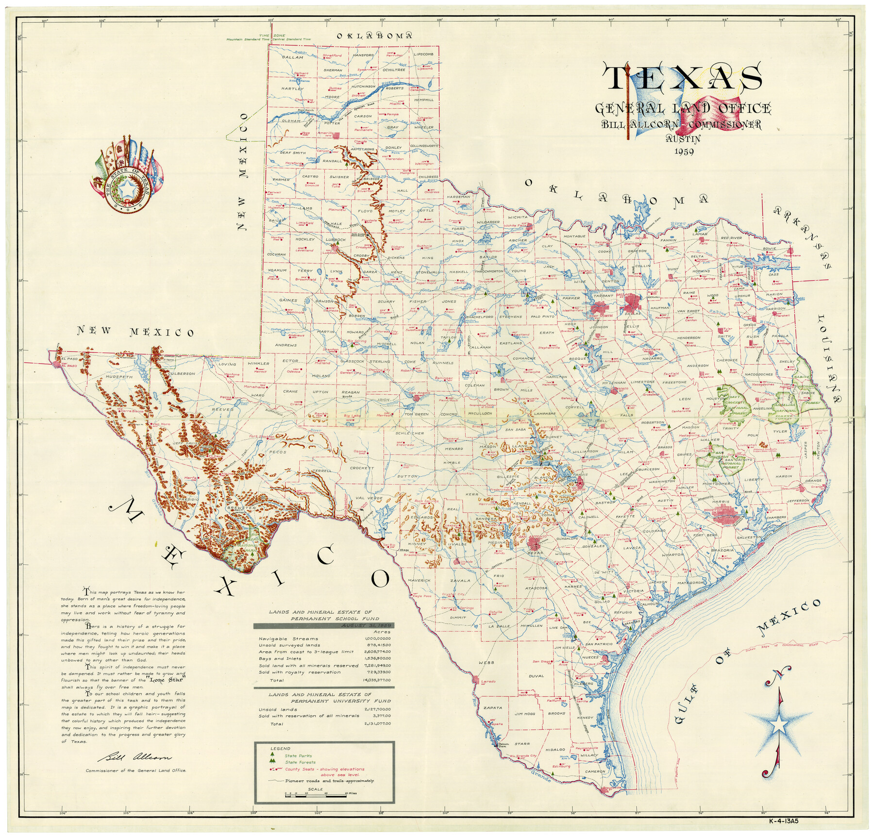
Texas
K-4-13a5
-
Map/Doc
2151
-
Collection
General Map Collection
-
Object Dates
1959 (Creation Date)
-
People and Organizations
General Land Office (Publisher)
Bill Allcorn (GLO Commissioner)
[Eltea Armstrong] (Draftsman)
-
Subjects
State of Texas
-
Height x Width
32.8 x 34.5 inches
83.3 x 87.6 cm
-
Medium
paper, print
Part of: General Map Collection
Flight Mission No. DAG-18K, Frame 188, Matagorda County

Print $20.00
- Digital $50.00
Flight Mission No. DAG-18K, Frame 188, Matagorda County
1952
Size 18.6 x 22.3 inches
Map/Doc 86380
Flight Mission No. DIX-5P, Frame 141, Aransas County

Print $20.00
- Digital $50.00
Flight Mission No. DIX-5P, Frame 141, Aransas County
1956
Size 17.8 x 18.4 inches
Map/Doc 83802
Crane County Rolled Sketch 29

Print $20.00
- Digital $50.00
Crane County Rolled Sketch 29
2024
Size 24.6 x 35.5 inches
Map/Doc 97338
Padre Island National Seashore, Texas - Dependent Resurvey

Print $2.00
- Digital $50.00
Padre Island National Seashore, Texas - Dependent Resurvey
Size 11.5 x 8.3 inches
Map/Doc 60542
Map from the Sabine River to the Rio Grande as subdivided for mineral development

Print $40.00
- Digital $50.00
Map from the Sabine River to the Rio Grande as subdivided for mineral development
Size 43.5 x 72.5 inches
Map/Doc 65802
Travis County Appraisal District Plat Map 2_3215

Print $20.00
- Digital $50.00
Travis County Appraisal District Plat Map 2_3215
Size 21.5 x 26.4 inches
Map/Doc 94222
Kleberg County Boundary File 2d

Print $20.00
- Digital $50.00
Kleberg County Boundary File 2d
Size 9.1 x 34.6 inches
Map/Doc 64980
Trinity River, Slate Rock Ferry Sheet/East Fork of Trinity River

Print $6.00
- Digital $50.00
Trinity River, Slate Rock Ferry Sheet/East Fork of Trinity River
1922
Size 35.1 x 34.3 inches
Map/Doc 65185
Loving County Sketch File 1

Print $4.00
- Digital $50.00
Loving County Sketch File 1
1931
Size 11.2 x 8.6 inches
Map/Doc 30407
Crockett County Working Sketch 93

Print $40.00
- Digital $50.00
Crockett County Working Sketch 93
1979
Size 43.5 x 65.4 inches
Map/Doc 68426
Leon County Rolled Sketch 14A

Print $200.00
- Digital $50.00
Leon County Rolled Sketch 14A
1975
Size 16.5 x 35.5 inches
Map/Doc 46535
Flight Mission No. BRA-8M, Frame 123, Jefferson County

Print $20.00
- Digital $50.00
Flight Mission No. BRA-8M, Frame 123, Jefferson County
1953
Size 18.7 x 22.3 inches
Map/Doc 85619
You may also like
Nueces County Rolled Sketch 2

Print $20.00
- Digital $50.00
Nueces County Rolled Sketch 2
1907
Size 18.4 x 35.8 inches
Map/Doc 6865
Val Verde County Rolled Sketch 79

Print $20.00
- Digital $50.00
Val Verde County Rolled Sketch 79
1983
Size 25.6 x 21.7 inches
Map/Doc 8141
[Dallam County Map]
![93157, [Dallam County Map], Twichell Survey Records](https://historictexasmaps.com/wmedia_w700/maps/93157-1.tif.jpg)
Print $40.00
- Digital $50.00
[Dallam County Map]
Size 51.1 x 65.2 inches
Map/Doc 93157
The Republic County of Fort Bend. December 29, 1845

Print $20.00
The Republic County of Fort Bend. December 29, 1845
2020
Size 14.7 x 21.6 inches
Map/Doc 96142
Lynn County Sketch File 16

Print $20.00
- Digital $50.00
Lynn County Sketch File 16
Size 31.6 x 47.5 inches
Map/Doc 10530
Ward County Working Sketch 23

Print $40.00
- Digital $50.00
Ward County Working Sketch 23
1953
Size 29.1 x 59.5 inches
Map/Doc 72329
Webb County Working Sketch 2

Print $20.00
- Digital $50.00
Webb County Working Sketch 2
1906
Size 11.2 x 12.5 inches
Map/Doc 72367
Jones County Sketch File 9

Print $22.00
- Digital $50.00
Jones County Sketch File 9
Size 8.3 x 7.5 inches
Map/Doc 28495
Township 6 North Range 13 West, North Western District, Louisiana

Print $20.00
- Digital $50.00
Township 6 North Range 13 West, North Western District, Louisiana
1841
Size 19.7 x 24.8 inches
Map/Doc 65864
Jeff Davis County Rolled Sketch 42

Print $20.00
- Digital $50.00
Jeff Davis County Rolled Sketch 42
1998
Size 26.8 x 18.9 inches
Map/Doc 76415

Trinity County Sketch File 18 1/2

Print $4.00
- Digital $50.00
Trinity County Sketch File 18 1/2
1876
Size 9.0 x 11.2 inches
Map/Doc 38548