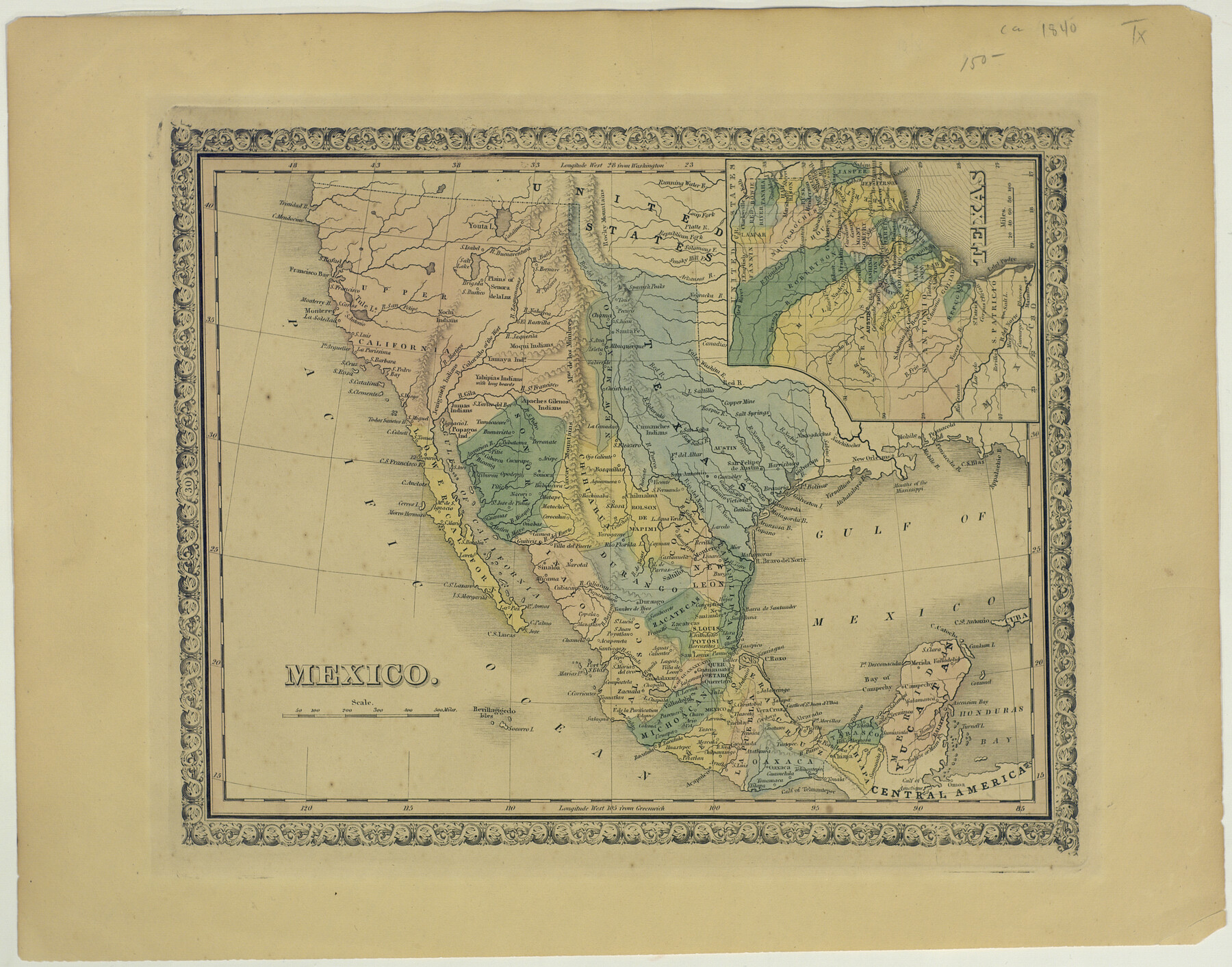
Mexico
-
Map/Doc
94570
-
Collection
Non-GLO Digital Images
-
Object Dates
[1839-1845 ca.] (Creation Date)
-
Subjects
Mexico Republic of Texas
-
Height x Width
12.2 x 15.6 inches
31.0 x 39.6 cm
-
Medium
digital image
-
Comments
Image provided by Ambassador Chase Untermeyer in June 2018.
Also features an inset map of Texas.
Part of: Non-GLO Digital Images
Carta Esférica del Seno Mexicano y Canales Viexo y de Bama

Carta Esférica del Seno Mexicano y Canales Viexo y de Bama
1797
Size 26.7 x 47.1 inches
Map/Doc 94569
Carta Particular de las Costas Setentrionales del Seno Mexicano que comprehende las de la Florida Ocidental las Margenes de la Luisiana y toda la rivera que sigue por la Bahía de San Bernardo y el Río Bravo del Norte hasta la Laguna Madre

Carta Particular de las Costas Setentrionales del Seno Mexicano que comprehende las de la Florida Ocidental las Margenes de la Luisiana y toda la rivera que sigue por la Bahía de San Bernardo y el Río Bravo del Norte hasta la Laguna Madre
1825
Size 26.1 x 38.7 inches
Map/Doc 94568
Fort Worth, Tex. "The Queen of the Prairies," County Seat of Tarrant County

Print $20.00
Fort Worth, Tex. "The Queen of the Prairies," County Seat of Tarrant County
1886
Size 26.0 x 33.3 inches
Map/Doc 89082
A Map of the United States of Mexico as organized and defined by the several Acts of the Congress of that Republic

Print $20.00
A Map of the United States of Mexico as organized and defined by the several Acts of the Congress of that Republic
1826
Size 23.2 x 28.9 inches
Map/Doc 93635
Mapa del Ferro-Carril del Rio Grande, Condado de Cameron Texas

Mapa del Ferro-Carril del Rio Grande, Condado de Cameron Texas
Size 18.4 x 72.5 inches
Map/Doc 94564
A Geological Map of the United States

Print $20.00
A Geological Map of the United States
Size 10.2 x 15.9 inches
Map/Doc 95281
[Movements & Objectives of the 143rd & 144th Infantry on October 9-11, 1918, Appendix E, Nos.2 and 3] - Verso
![94132, [Movements & Objectives of the 143rd & 144th Infantry on October 9-11, 1918, Appendix E, Nos.2 and 3] - Verso, Non-GLO Digital Images](https://historictexasmaps.com/wmedia_w700/maps/94132-1.tif.jpg)
Print $20.00
[Movements & Objectives of the 143rd & 144th Infantry on October 9-11, 1918, Appendix E, Nos.2 and 3] - Verso
1918
Size 41.9 x 20.2 inches
Map/Doc 94132
The Rand-McNally New Commercial Atlas Map of Texas

Print $20.00
The Rand-McNally New Commercial Atlas Map of Texas
1914
Size 28.6 x 42.4 inches
Map/Doc 78225
Austin, State Capital of Texas

Print $20.00
Austin, State Capital of Texas
1887
Size 27.5 x 40.0 inches
Map/Doc 89218
[Movements & Objectives of the 143rd & 144th Infantry on October 13, 1918, Appendix L]
![94124, [Movements & Objectives of the 143rd & 144th Infantry on October 13, 1918, Appendix L], Non-GLO Digital Images](https://historictexasmaps.com/wmedia_w700/maps/94124-1.tif.jpg)
Print $20.00
[Movements & Objectives of the 143rd & 144th Infantry on October 13, 1918, Appendix L]
1918
Size 16.1 x 16.8 inches
Map/Doc 94124
Bird's Eye View of Cuero, De Witt County, Texas

Print $20.00
Bird's Eye View of Cuero, De Witt County, Texas
1881
Size 18.4 x 25.5 inches
Map/Doc 89079
Perspective Map of the City of Laredo, Texas, the Gateway to and from Mexico

Print $20.00
Perspective Map of the City of Laredo, Texas, the Gateway to and from Mexico
1892
Size 22.1 x 34.2 inches
Map/Doc 89098
You may also like
Refugio County Sketch File 14

Print $2.00
- Digital $50.00
Refugio County Sketch File 14
Size 12.8 x 8.1 inches
Map/Doc 35267
Victoria County Sketch File 1

Print $20.00
- Digital $50.00
Victoria County Sketch File 1
1853
Size 12.9 x 17.3 inches
Map/Doc 12595
General Highway Map, Eastland County, Texas

Print $20.00
General Highway Map, Eastland County, Texas
1940
Size 18.1 x 24.8 inches
Map/Doc 79080
Sketch in Parmer County

Print $20.00
- Digital $50.00
Sketch in Parmer County
1901
Size 15.1 x 23.8 inches
Map/Doc 91644
Webb County Working Sketch 6

Print $20.00
- Digital $50.00
Webb County Working Sketch 6
1909
Size 27.8 x 28.3 inches
Map/Doc 72371
Atascosa County Working Sketch 30

Print $20.00
- Digital $50.00
Atascosa County Working Sketch 30
1980
Size 16.4 x 20.6 inches
Map/Doc 67226
Mills County Working Sketch 26

Print $20.00
- Digital $50.00
Mills County Working Sketch 26
1993
Size 18.2 x 26.2 inches
Map/Doc 71056
Darrington Plantation of the Texas Prison System, Brazoria County

Print $20.00
- Digital $50.00
Darrington Plantation of the Texas Prison System, Brazoria County
Size 16.9 x 37.4 inches
Map/Doc 62986
Nueces County Aerial Photograph Index Sheet 21

Print $20.00
- Digital $50.00
Nueces County Aerial Photograph Index Sheet 21
1938
Size 24.3 x 20.2 inches
Map/Doc 86842
Liberty County Sketch File AX

Print $10.00
- Digital $50.00
Liberty County Sketch File AX
1899
Size 14.1 x 8.5 inches
Map/Doc 30061
Fisher County Sketch File 19a

Print $42.00
- Digital $50.00
Fisher County Sketch File 19a
1898
Size 14.1 x 8.9 inches
Map/Doc 22595
Fannin County Rolled Sketch 18D

Print $2.00
- Digital $50.00
Fannin County Rolled Sketch 18D
Size 12.9 x 8.1 inches
Map/Doc 5871