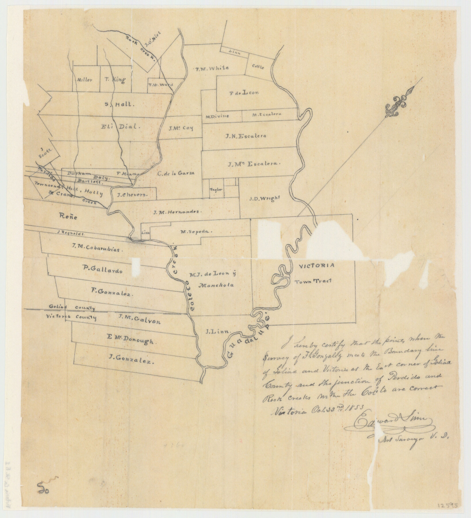
Victoria County Sketch File 1
[Sketch of surveys between the Guadalupe River and Coleto Creek]
-
Map/Doc
12595
-
Collection
General Map Collection
-
Object Dates
10/22/1853 (Creation Date)
-
People and Organizations
Edward Linn (Surveyor/Engineer)
-
Counties
Victoria
-
Subjects
Surveying Sketch File
-
Height x Width
12.9 x 17.3 inches
32.8 x 43.9 cm
-
Medium
paper, manuscript
-
Features
Rock Creek
Perdido Creek
Coleto Creek
Guadalupe River
Victoria
Part of: General Map Collection
Andrews County Working Sketch 9

Print $20.00
- Digital $50.00
Andrews County Working Sketch 9
1955
Size 10.2 x 23.3 inches
Map/Doc 67055

Brewster County Rolled Sketch 144A

Print $40.00
- Digital $50.00
Brewster County Rolled Sketch 144A
Size 53.4 x 43.5 inches
Map/Doc 9195
Stonewall County Working Sketch 9

Print $20.00
- Digital $50.00
Stonewall County Working Sketch 9
1950
Size 27.9 x 34.1 inches
Map/Doc 62316
Stephens County Sketch File 13

Print $4.00
- Digital $50.00
Stephens County Sketch File 13
Size 11.2 x 8.8 inches
Map/Doc 37063
Map of Chicago, Rock Island & Texas Railway through Tarrant County, Texas

Print $20.00
- Digital $50.00
Map of Chicago, Rock Island & Texas Railway through Tarrant County, Texas
1893
Size 20.7 x 35.7 inches
Map/Doc 64414
Terrell County Working Sketch 6

Print $20.00
- Digital $50.00
Terrell County Working Sketch 6
1914
Size 15.7 x 21.9 inches
Map/Doc 62155
Flight Mission No. BQY-4M, Frame 56, Harris County

Print $20.00
- Digital $50.00
Flight Mission No. BQY-4M, Frame 56, Harris County
1953
Size 18.6 x 22.4 inches
Map/Doc 85265
Carson County Boundary File 5b

Print $10.00
- Digital $50.00
Carson County Boundary File 5b
Size 11.7 x 8.6 inches
Map/Doc 51141
Borden County Working Sketch 12

Print $20.00
- Digital $50.00
Borden County Working Sketch 12
1956
Size 43.1 x 37.0 inches
Map/Doc 67472
Haskell County Sketch File 3

Print $8.00
- Digital $50.00
Haskell County Sketch File 3
Size 9.8 x 8.8 inches
Map/Doc 26121
Bexar County Sketch File 55

Print $20.00
- Digital $50.00
Bexar County Sketch File 55
1838
Size 13.3 x 8.3 inches
Map/Doc 14560
You may also like
Wharton County Sketch File 8

Print $4.00
- Digital $50.00
Wharton County Sketch File 8
1882
Size 8.9 x 10.1 inches
Map/Doc 39927

Denton County Sketch File 25

Print $4.00
- Digital $50.00
Denton County Sketch File 25
1863
Size 8.0 x 7.4 inches
Map/Doc 20752
Victoria County Boundary File 91

Print $12.00
- Digital $50.00
Victoria County Boundary File 91
Size 8.9 x 6.5 inches
Map/Doc 59620
USGS Topographic, De Kalb NW, Texas Quadrangle

Print $20.00
- Digital $50.00
USGS Topographic, De Kalb NW, Texas Quadrangle
1950
Size 26.8 x 21.6 inches
Map/Doc 77604
Red River County Working Sketch 21

Print $20.00
- Digital $50.00
Red River County Working Sketch 21
1955
Size 33.2 x 18.5 inches
Map/Doc 72004
Flight Mission No. CRE-1R, Frame 195, Jackson County

Print $20.00
- Digital $50.00
Flight Mission No. CRE-1R, Frame 195, Jackson County
1956
Size 18.6 x 22.3 inches
Map/Doc 85349
Scurry County Sketch Mineral Application No. 42315

Print $20.00
- Digital $50.00
Scurry County Sketch Mineral Application No. 42315
1950
Size 24.0 x 16.5 inches
Map/Doc 92965
Cunningham Addition and Massey Heights

Print $20.00
- Digital $50.00
Cunningham Addition and Massey Heights
Size 18.9 x 24.9 inches
Map/Doc 92744
Flight Mission No. DQN-5K, Frame 58, Calhoun County

Print $20.00
- Digital $50.00
Flight Mission No. DQN-5K, Frame 58, Calhoun County
1953
Size 15.5 x 15.3 inches
Map/Doc 84401
Duval County Working Sketch 34

Print $20.00
- Digital $50.00
Duval County Working Sketch 34
1953
Size 35.8 x 25.5 inches
Map/Doc 68758
Dimmit County Sketch File 11a

Print $20.00
- Digital $50.00
Dimmit County Sketch File 11a
1880
Size 12.9 x 18.7 inches
Map/Doc 11339