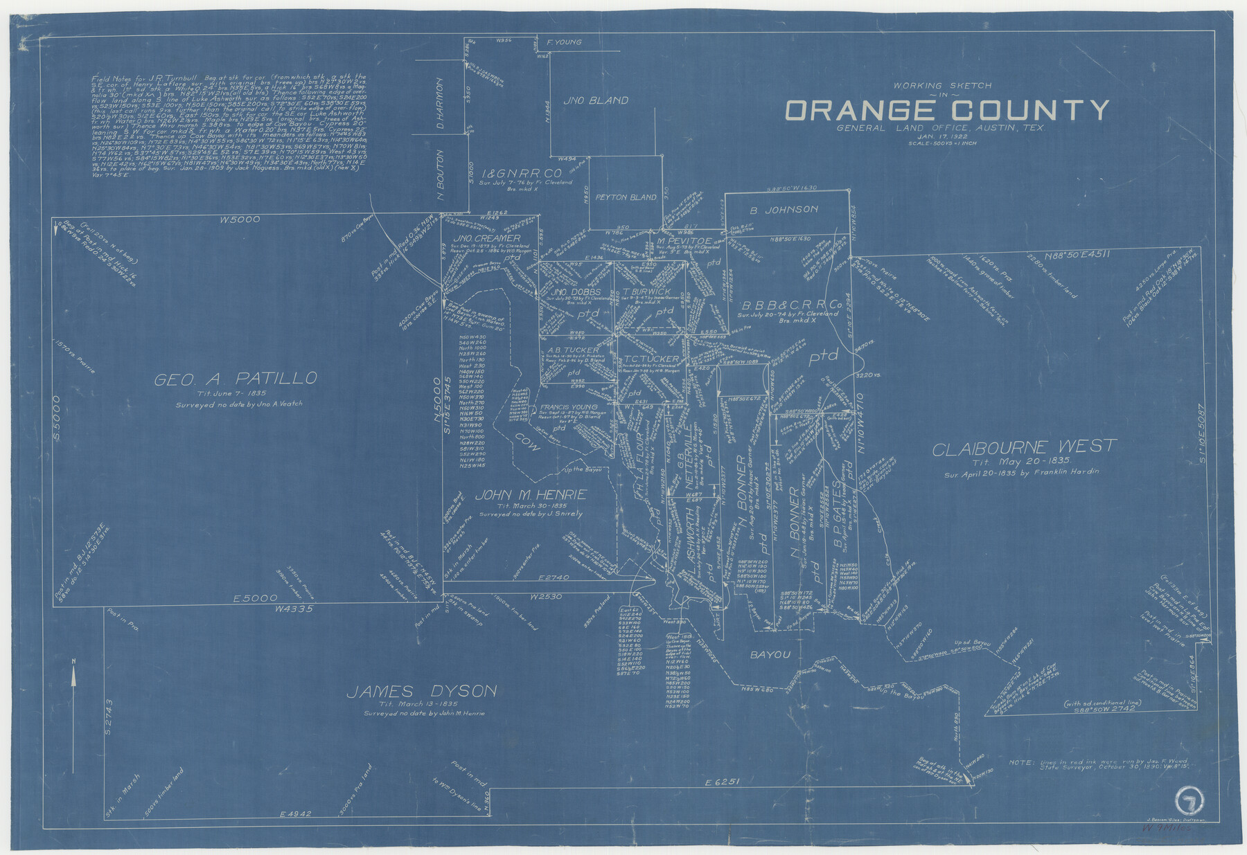
Orange County Working Sketch 7
-
Map/Doc
71339
-
Collection
General Map Collection
-
Object Dates
1/17/1922 (Creation Date)
-
People and Organizations
J. Bascom Giles (Draftsman)
-
Counties
Orange
-
Subjects
Surveying Working Sketch
-
Height x Width
21.9 x 31.9 inches
55.6 x 81.0 cm
-
Scale
1" = 500 varas
Part of: General Map Collection
Fort Bend County Sketch File 27

Print $20.00
- Digital $50.00
Fort Bend County Sketch File 27
1910
Size 17.9 x 37.7 inches
Map/Doc 10453
Crockett County Rolled Sketch 69

Print $40.00
- Digital $50.00
Crockett County Rolled Sketch 69
1949
Size 39.4 x 54.8 inches
Map/Doc 8721
Aransas County NRC Article 33.136 Sketch 2

Print $26.00
- Digital $50.00
Aransas County NRC Article 33.136 Sketch 2
2001
Size 18.6 x 24.2 inches
Map/Doc 61643
Railroad and County Map of Texas

Print $20.00
- Digital $50.00
Railroad and County Map of Texas
1926
Size 42.9 x 45.2 inches
Map/Doc 65799
Houston County State Real Property Sketch 1

Print $20.00
- Digital $50.00
Houston County State Real Property Sketch 1
1997
Size 35.5 x 24.4 inches
Map/Doc 80129
Southern Part of Laguna Madre

Print $20.00
- Digital $50.00
Southern Part of Laguna Madre
1981
Size 45.1 x 35.8 inches
Map/Doc 73546
Johnson County Working Sketch 17

Print $40.00
- Digital $50.00
Johnson County Working Sketch 17
1985
Size 48.3 x 44.4 inches
Map/Doc 66630
Outer Continental Shelf Leasing Maps (Texas Offshore Operations)

Print $20.00
- Digital $50.00
Outer Continental Shelf Leasing Maps (Texas Offshore Operations)
1954
Size 22.3 x 17.3 inches
Map/Doc 75833
Willacy County Rolled Sketch 2

Print $40.00
- Digital $50.00
Willacy County Rolled Sketch 2
1921
Size 30.7 x 62.9 inches
Map/Doc 10145
Calhoun County Rolled Sketch 27

Print $127.00
- Digital $50.00
Calhoun County Rolled Sketch 27
1976
Size 10.1 x 16.0 inches
Map/Doc 43621
Dallas County Boundary File 4b

Print $12.00
- Digital $50.00
Dallas County Boundary File 4b
Size 10.8 x 8.3 inches
Map/Doc 52154
Gregg County Rolled Sketch 18

Print $40.00
- Digital $50.00
Gregg County Rolled Sketch 18
1934
Size 71.1 x 46.3 inches
Map/Doc 9068
You may also like
Dickens County Sketch File 6a

Print $6.00
- Digital $50.00
Dickens County Sketch File 6a
1882
Size 16.5 x 9.4 inches
Map/Doc 20969
[Sketch for Mineral Application 33721 - 33725 Incl. - Padre and Mustang Island]
![2869, [Sketch for Mineral Application 33721 - 33725 Incl. - Padre and Mustang Island], General Map Collection](https://historictexasmaps.com/wmedia_w700/maps/2869.tif.jpg)
Print $20.00
- Digital $50.00
[Sketch for Mineral Application 33721 - 33725 Incl. - Padre and Mustang Island]
1942
Size 22.2 x 22.3 inches
Map/Doc 2869


Sutton County Sketch File 52

Print $6.00
- Digital $50.00
Sutton County Sketch File 52
1948
Size 11.2 x 8.8 inches
Map/Doc 37529
Young County Rolled Sketch 6

Print $20.00
- Digital $50.00
Young County Rolled Sketch 6
Size 43.4 x 30.8 inches
Map/Doc 8294
Map of the United States with its territories: also Mexico and the West Indies

Print $20.00
- Digital $50.00
Map of the United States with its territories: also Mexico and the West Indies
1851
Size 40.1 x 36.7 inches
Map/Doc 93925
San Patricio County Rolled Sketch 25

Print $40.00
- Digital $50.00
San Patricio County Rolled Sketch 25
1925
Size 37.2 x 54.1 inches
Map/Doc 9887
Newton County Working Sketch 30

Print $20.00
- Digital $50.00
Newton County Working Sketch 30
1955
Size 18.2 x 17.8 inches
Map/Doc 71276
Pecos County Working Sketch 112

Print $40.00
- Digital $50.00
Pecos County Working Sketch 112
Size 48.1 x 37.0 inches
Map/Doc 71585
Houston including Bellaire, Bunker Hill, Galena Park, Hedwig, Hilshire, Hunters Creek, Jacinto City, Jersey Village, Missouri City, Pasadena, Piney Point, South Houston, Spring Valley, West University Place and adjoining communities [Recto]
![94179, Houston including Bellaire, Bunker Hill, Galena Park, Hedwig, Hilshire, Hunters Creek, Jacinto City, Jersey Village, Missouri City, Pasadena, Piney Point, South Houston, Spring Valley, West University Place and adjoining communities [Recto], General Map Collection](https://historictexasmaps.com/wmedia_w700/maps/94179.tif.jpg)
Houston including Bellaire, Bunker Hill, Galena Park, Hedwig, Hilshire, Hunters Creek, Jacinto City, Jersey Village, Missouri City, Pasadena, Piney Point, South Houston, Spring Valley, West University Place and adjoining communities [Recto]
Size 27.1 x 42.6 inches
Map/Doc 94179
Map of survey of the 100th Meridian west longitude, extending from the north bank of Red River to the intersection of the Northern Boundary of the Creek or Seminole Country

Print $20.00
- Digital $50.00
Map of survey of the 100th Meridian west longitude, extending from the north bank of Red River to the intersection of the Northern Boundary of the Creek or Seminole Country
1859
Size 30.8 x 9.9 inches
Map/Doc 3091