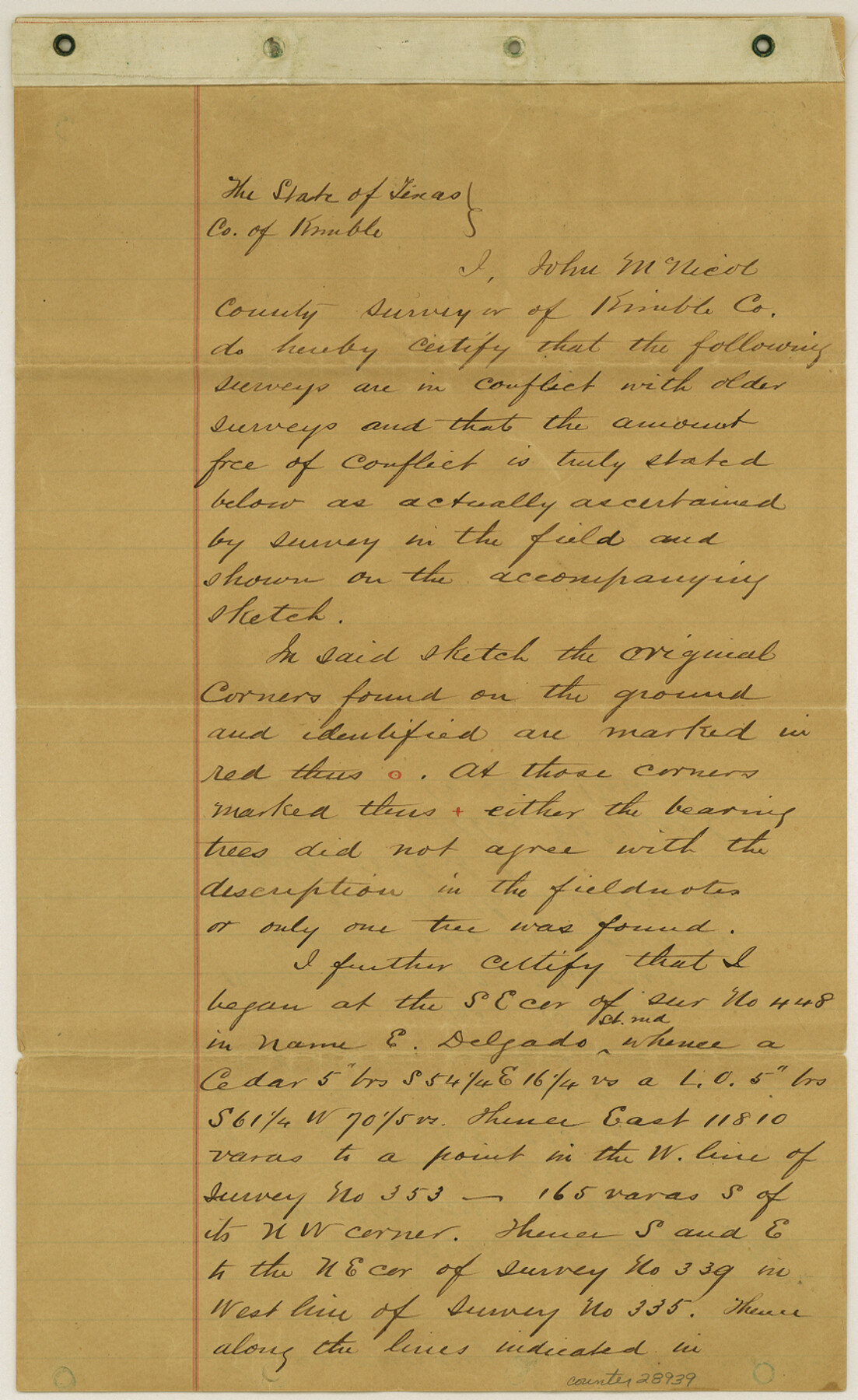
Kimble County Sketch File 14
[Sketch and explanation regarding area in the east part of Kimble County and south part of Mason County]
-
Map/Doc
28939
-
Collection
General Map Collection
-
Object Dates
3/5/1886 (Creation Date)
6/1/1886 (File Date)
-
People and Organizations
John McNicol (Surveyor/Engineer)
-
Counties
Kimble Mason Gillespie
-
Subjects
Surveying Sketch File
-
Height x Width
14.1 x 8.6 inches
35.8 x 21.8 cm
-
Medium
paper, manuscript
Part of: General Map Collection
Bexar County Working Sketch 13

Print $20.00
- Digital $50.00
Bexar County Working Sketch 13
1968
Size 43.5 x 43.7 inches
Map/Doc 67329
Houston County Sketch File 8

Print $22.00
- Digital $50.00
Houston County Sketch File 8
1858
Size 12.9 x 8.3 inches
Map/Doc 26768
Trace of a copy of the map captured at the battle of Resaca de la Palma

Print $20.00
- Digital $50.00
Trace of a copy of the map captured at the battle of Resaca de la Palma
Size 18.3 x 27.6 inches
Map/Doc 73053
La Salle County Rolled Sketch 12

Print $20.00
- Digital $50.00
La Salle County Rolled Sketch 12
Size 25.3 x 37.2 inches
Map/Doc 6575
Presidio County Sketch File 116A

Print $63.00
- Digital $50.00
Presidio County Sketch File 116A
Size 17.0 x 11.0 inches
Map/Doc 34885
Morris County Rolled Sketch 2A

Print $20.00
- Digital $50.00
Morris County Rolled Sketch 2A
Size 24.3 x 19.1 inches
Map/Doc 10242
Shelby County

Print $40.00
- Digital $50.00
Shelby County
1897
Size 43.9 x 49.3 inches
Map/Doc 16814
Hidalgo County Working Sketch 3

Print $20.00
- Digital $50.00
Hidalgo County Working Sketch 3
1941
Size 41.1 x 32.8 inches
Map/Doc 66180
Nueces County Aerial Photograph Index Sheet 23

Print $20.00
- Digital $50.00
Nueces County Aerial Photograph Index Sheet 23
1938
Size 24.4 x 20.3 inches
Map/Doc 86844
Shackelford County Rolled Sketch 2

Print $40.00
- Digital $50.00
Shackelford County Rolled Sketch 2
Size 18.9 x 51.9 inches
Map/Doc 75935
DeWitt County Sketch File 13

Print $8.00
- Digital $50.00
DeWitt County Sketch File 13
1845
Size 12.8 x 8.2 inches
Map/Doc 20824
Flight Mission No. BRA-3M, Frame 122, Jefferson County

Print $20.00
- Digital $50.00
Flight Mission No. BRA-3M, Frame 122, Jefferson County
1953
Size 18.7 x 22.3 inches
Map/Doc 85396
You may also like
Live Oak County Rolled Sketch 10A

Print $20.00
- Digital $50.00
Live Oak County Rolled Sketch 10A
1983
Size 38.4 x 43.6 inches
Map/Doc 9457
Maverick County Rolled Sketch 13

Print $20.00
- Digital $50.00
Maverick County Rolled Sketch 13
1848
Size 34.4 x 26.5 inches
Map/Doc 6706

Map of the country adjacent to the left bank of the Rio Grande below Matamoros surveyed under instructions of Col. J.J. Abert, Corps. Top. Engrs.

Print $20.00
- Digital $50.00
Map of the country adjacent to the left bank of the Rio Grande below Matamoros surveyed under instructions of Col. J.J. Abert, Corps. Top. Engrs.
Size 27.0 x 20.9 inches
Map/Doc 95177
Comal County Sketch File 12

Print $4.00
- Digital $50.00
Comal County Sketch File 12
Size 8.4 x 11.3 inches
Map/Doc 19024
Texas Intracoastal Waterway, Aransas Bay to Aransas Pass

Print $20.00
- Digital $50.00
Texas Intracoastal Waterway, Aransas Bay to Aransas Pass
1962
Size 26.8 x 38.7 inches
Map/Doc 73438
Castro County Working Sketch 6

Print $20.00
- Digital $50.00
Castro County Working Sketch 6
1975
Size 28.4 x 26.4 inches
Map/Doc 67901
[Surveying Sketch of John Knight, Champion Choate, A. M. Lejarza, et al in Hardin County, Texas - Exhibit "G"]
![75821, [Surveying Sketch of John Knight, Champion Choate, A. M. Lejarza, et al in Hardin County, Texas - Exhibit "G"], Maddox Collection](https://historictexasmaps.com/wmedia_w700/maps/75821.tif.jpg)
Print $20.00
- Digital $50.00
[Surveying Sketch of John Knight, Champion Choate, A. M. Lejarza, et al in Hardin County, Texas - Exhibit "G"]
Size 18.3 x 23.5 inches
Map/Doc 75821
Cochran County Rolled Sketch 4

Print $20.00
- Digital $50.00
Cochran County Rolled Sketch 4
1945
Size 16.8 x 23.7 inches
Map/Doc 5501
Runnels County Sketch File 13

Print $2.00
Runnels County Sketch File 13
Size 8.0 x 6.2 inches
Map/Doc 35456
Map of Yoakum County

Print $20.00
- Digital $50.00
Map of Yoakum County
1902
Size 47.2 x 35.3 inches
Map/Doc 16934
Hammond's continental map of the United States

Digital $50.00
Hammond's continental map of the United States
1940
Size 33.2 x 50.2 inches
Map/Doc 3118