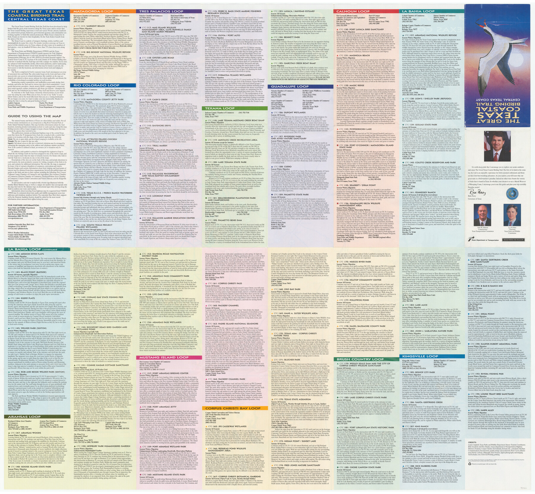
The Great Texas Coastal Birding Trail, Central Texas Coast
[Verso - Description of Various Birding Loops]
-
Map/Doc
94340
-
Collection
General Map Collection
-
Object Dates
1996 (Copyright Date)
2001 (Edition Date)
-
People and Organizations
TxDOT/TPW (Publisher)
-
Subjects
State of Texas
-
Height x Width
33.3 x 36.0 inches
84.6 x 91.4 cm
-
Medium
paper, etching/engraving/lithograph
-
Comments
For map on recto, see 94339. For research only.
Related maps
The Great Texas Coastal Birding Trail, Central Texas Coast

The Great Texas Coastal Birding Trail, Central Texas Coast
Size 33.1 x 36.0 inches
Map/Doc 94339
Part of: General Map Collection
Pecos County Working Sketch 23

Print $20.00
- Digital $50.00
Pecos County Working Sketch 23
1927
Size 45.6 x 40.6 inches
Map/Doc 71494
Jefferson County Working Sketch 7

Print $20.00
- Digital $50.00
Jefferson County Working Sketch 7
1931
Size 18.0 x 18.6 inches
Map/Doc 66550

Harris County Working Sketch 99

Print $20.00
- Digital $50.00
Harris County Working Sketch 99
1979
Size 46.6 x 30.1 inches
Map/Doc 65991
Harrison County Working Sketch 1

Print $20.00
- Digital $50.00
Harrison County Working Sketch 1
1919
Size 22.6 x 25.6 inches
Map/Doc 66021
Cooke County Working Sketch 29
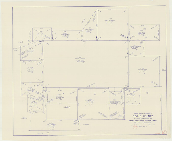
Print $20.00
- Digital $50.00
Cooke County Working Sketch 29
1977
Size 28.7 x 35.0 inches
Map/Doc 68266
Erath County Sketch File 8a

Print $6.00
- Digital $50.00
Erath County Sketch File 8a
1853
Size 15.9 x 11.0 inches
Map/Doc 22271
Angelina County Rolled Sketch 4

Print $20.00
- Digital $50.00
Angelina County Rolled Sketch 4
Size 24.9 x 36.9 inches
Map/Doc 77187
Midland County Rolled Sketch 5

Print $20.00
- Digital $50.00
Midland County Rolled Sketch 5
Size 35.3 x 44.8 inches
Map/Doc 10695
Rusk County Sketch File Z

Print $6.00
Rusk County Sketch File Z
1850
Size 15.8 x 9.0 inches
Map/Doc 35539
Lubbock County Working Sketch 5

Print $20.00
- Digital $50.00
Lubbock County Working Sketch 5
1950
Size 14.3 x 31.0 inches
Map/Doc 70665
Victoria County Working Sketch 5

Print $20.00
- Digital $50.00
Victoria County Working Sketch 5
1944
Size 35.2 x 40.8 inches
Map/Doc 72275
You may also like
Polk County Rolled Sketch 33

Print $20.00
- Digital $50.00
Polk County Rolled Sketch 33
Size 26.5 x 38.5 inches
Map/Doc 7319
Map of Padre Island Showing Location of Zoning Districts

Print $20.00
- Digital $50.00
Map of Padre Island Showing Location of Zoning Districts
1971
Size 18.6 x 26.1 inches
Map/Doc 4810
Flight Mission No. BRA-6M, Frame 81, Jefferson County

Print $20.00
- Digital $50.00
Flight Mission No. BRA-6M, Frame 81, Jefferson County
1953
Size 18.6 x 22.6 inches
Map/Doc 85425
Starr County Sketch File 52

Print $4.00
- Digital $50.00
Starr County Sketch File 52
Size 13.9 x 9.0 inches
Map/Doc 37011
Amended and Corrected Map of Adrian and Adrian Heights Addition Situated in Oldham County, Texas on Sections 14, 15, 38, 39 and 16 Respectively

Print $20.00
- Digital $50.00
Amended and Corrected Map of Adrian and Adrian Heights Addition Situated in Oldham County, Texas on Sections 14, 15, 38, 39 and 16 Respectively
Size 31.5 x 43.5 inches
Map/Doc 89801
Sketch of surveys on Deer Creek, Milam District

Print $2.00
- Digital $50.00
Sketch of surveys on Deer Creek, Milam District
1846
Size 7.8 x 10.9 inches
Map/Doc 76046
Map of Capitol Syndicate Subdivisions of Capitol Land Reservation Leagues

Print $40.00
- Digital $50.00
Map of Capitol Syndicate Subdivisions of Capitol Land Reservation Leagues
1906
Size 44.6 x 72.6 inches
Map/Doc 93131
Dawson County Sketch File 23

Print $4.00
- Digital $50.00
Dawson County Sketch File 23
Size 9.2 x 11.5 inches
Map/Doc 20575
[Rusk, Sutton, Garza, and Atascosa County School Lands]
![91125, [Rusk, Sutton, Garza, and Atascosa County School Lands], Twichell Survey Records](https://historictexasmaps.com/wmedia_w700/maps/91125-1.tif.jpg)
Print $3.00
- Digital $50.00
[Rusk, Sutton, Garza, and Atascosa County School Lands]
1913
Size 12.5 x 9.4 inches
Map/Doc 91125

Sketch showing progress of topographical work Laguna Madre and vicinity from Rainey Is. to Baffins Bay, Coast of Texas Sect. IX [and accompanying letter]
![72961, Sketch showing progress of topographical work Laguna Madre and vicinity from Rainey Is. to Baffins Bay, Coast of Texas Sect. IX [and accompanying letter], General Map Collection](https://historictexasmaps.com/wmedia_w700/maps/72961.tif.jpg)
Print $2.00
- Digital $50.00
Sketch showing progress of topographical work Laguna Madre and vicinity from Rainey Is. to Baffins Bay, Coast of Texas Sect. IX [and accompanying letter]
Size 11.1 x 8.7 inches
Map/Doc 72961
Provincias internas del Reyno de Nuevo España

Print $20.00
Provincias internas del Reyno de Nuevo España
1790
Size 31.0 x 24.0 inches
Map/Doc 95313