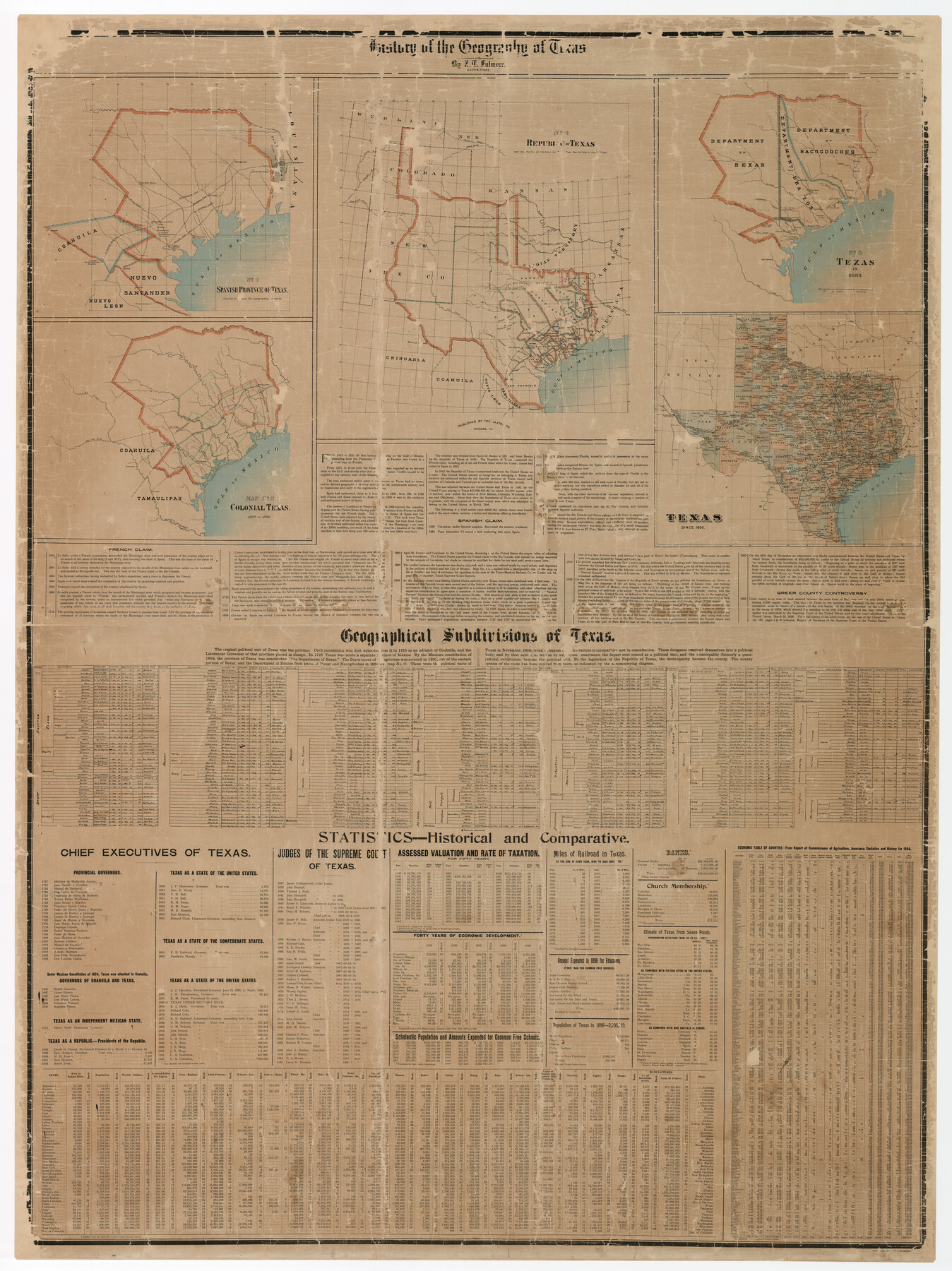
History of the Geography of Texas
K-4-34
-
Map/Doc
3095
-
Collection
General Map Collection
-
Object Dates
1897 (Creation Date)
-
People and Organizations
The Caxton Company (Author)
Z.T. Fulmore (Draftsman)
-
Subjects
State of Texas
-
Height x Width
70.7 x 52.9 inches
179.6 x 134.4 cm
-
Comments
Has tables and lists of facts plus small maps of Texas showing historical political divisions. See maps 93410-93414 for individual maps cropped from this larger item.
See Tracing the Sabine River: The History of Texas' Eastern Boundary for a StoryMap exploring this chapter in Texas' border history.
Conservation funded in 2003 with donation from Texas Monthly.
Related maps
Colonial Texas. 1822 to 1834.

Print $20.00
- Digital $50.00
Colonial Texas. 1822 to 1834.
1897
Size 12.8 x 16.3 inches
Map/Doc 93410
Republic of Texas and boundaries as claimed by Texas from Decr. 19th, 1836 to Novr. 26th, 1850

Print $20.00
- Digital $50.00
Republic of Texas and boundaries as claimed by Texas from Decr. 19th, 1836 to Novr. 26th, 1850
1897
Size 20.7 x 19.3 inches
Map/Doc 93411
Spanish Province of Texas compiled from map on file among archives at Saltillo

Print $20.00
- Digital $50.00
Spanish Province of Texas compiled from map on file among archives at Saltillo
1897
Size 13.6 x 16.0 inches
Map/Doc 93412
Texas since 1850

Print $20.00
- Digital $50.00
Texas since 1850
1897
Size 13.3 x 15.5 inches
Map/Doc 93413
Texas in 1835

Print $20.00
- Digital $50.00
Texas in 1835
1897
Size 13.4 x 15.3 inches
Map/Doc 93414
Part of: General Map Collection
[Sketch for Mineral Application 19144 - Pecos River Bed]
![65574, [Sketch for Mineral Application 19144 - Pecos River Bed], General Map Collection](https://historictexasmaps.com/wmedia_w700/maps/65574.tif.jpg)
Print $20.00
- Digital $50.00
[Sketch for Mineral Application 19144 - Pecos River Bed]
1927
Size 46.2 x 45.1 inches
Map/Doc 65574
Upton County Working Sketch 53

Print $20.00
- Digital $50.00
Upton County Working Sketch 53
1983
Size 26.8 x 31.2 inches
Map/Doc 69550
Calhoun County Boundary File 3

Print $8.00
- Digital $50.00
Calhoun County Boundary File 3
Size 11.3 x 8.7 inches
Map/Doc 50975
Victoria County Rolled Sketch 9

Print $20.00
- Digital $50.00
Victoria County Rolled Sketch 9
Size 24.1 x 36.1 inches
Map/Doc 95400
Leon County Working Sketch 37

Print $20.00
- Digital $50.00
Leon County Working Sketch 37
1979
Size 43.2 x 37.7 inches
Map/Doc 70436
Duval County Boundary File 1e

Print $40.00
- Digital $50.00
Duval County Boundary File 1e
Size 6.1 x 23.1 inches
Map/Doc 52701
Somervell County Working Sketch 2

Print $20.00
- Digital $50.00
Somervell County Working Sketch 2
1951
Size 22.4 x 23.8 inches
Map/Doc 63906
Foard County Sketch File 36

Print $20.00
- Digital $50.00
Foard County Sketch File 36
Size 15.4 x 28.0 inches
Map/Doc 11498
Coleman County

Print $40.00
- Digital $50.00
Coleman County
1897
Size 49.4 x 34.9 inches
Map/Doc 66758
Chambers County Working Sketch 6

Print $20.00
- Digital $50.00
Chambers County Working Sketch 6
1938
Size 14.3 x 19.7 inches
Map/Doc 67989
Llano County Sketch File 9

Print $42.00
- Digital $50.00
Llano County Sketch File 9
Size 8.6 x 13.1 inches
Map/Doc 30369
Marion County Working Sketch 37

Print $20.00
- Digital $50.00
Marion County Working Sketch 37
1986
Size 30.0 x 43.0 inches
Map/Doc 70813
You may also like
Robertson County Sketch File 7

Print $20.00
Robertson County Sketch File 7
1873
Size 16.3 x 24.0 inches
Map/Doc 12250
Baylor County Sketch File 8

Print $44.00
- Digital $50.00
Baylor County Sketch File 8
1887
Size 13.0 x 8.6 inches
Map/Doc 14137
Wood County Boundary File 1

Print $4.00
- Digital $50.00
Wood County Boundary File 1
Size 12.6 x 8.1 inches
Map/Doc 60154
The Chief Justice County of Harrisburg. Lands in Conflict with Brazoria, Liberty Counties

Print $20.00
The Chief Justice County of Harrisburg. Lands in Conflict with Brazoria, Liberty Counties
2020
Size 17.5 x 21.7 inches
Map/Doc 96050
Reeves County Working Sketch 8

Print $20.00
- Digital $50.00
Reeves County Working Sketch 8
1948
Size 22.1 x 31.0 inches
Map/Doc 63451
Tom Green County Sketch File 83

Print $20.00
- Digital $50.00
Tom Green County Sketch File 83
1889
Size 20.5 x 22.2 inches
Map/Doc 12455
Terrell County Working Sketch 12

Print $20.00
- Digital $50.00
Terrell County Working Sketch 12
1926
Size 18.3 x 21.0 inches
Map/Doc 62161
Pecos County Sketch File 54

Print $20.00
- Digital $50.00
Pecos County Sketch File 54
Size 14.5 x 22.4 inches
Map/Doc 12180
Eastland County Sketch File 19

Print $2.00
- Digital $50.00
Eastland County Sketch File 19
1983
Size 14.3 x 9.0 inches
Map/Doc 21608
Childress County Sketch File 19

Print $4.00
- Digital $50.00
Childress County Sketch File 19
Size 14.1 x 8.7 inches
Map/Doc 18294
McMullen County Rolled Sketch 22

Print $20.00
- Digital $50.00
McMullen County Rolled Sketch 22
2004
Size 15.3 x 24.6 inches
Map/Doc 88824
Harris County Rolled Sketch 72

Print $40.00
- Digital $50.00
Harris County Rolled Sketch 72
1945
Size 23.0 x 48.3 inches
Map/Doc 9132