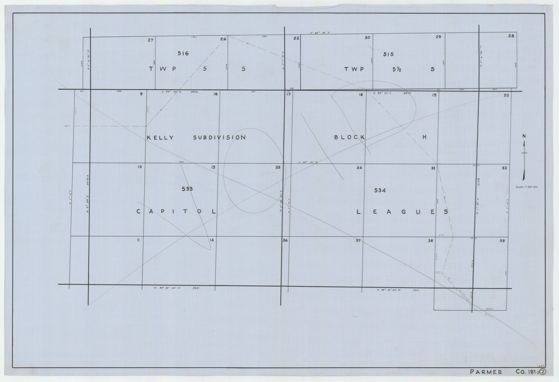
Brazos River Conservation and Reclamation District Official Boundary Line Survey, Parmer County
185-10
-
Map/Doc
91658
-
Collection
Twichell Survey Records
-
Counties
Parmer
-
Height x Width
24.5 x 16.9 inches
62.2 x 42.9 cm
Part of: Twichell Survey Records
Slaughter and Veal Lands, Howard and Borden Counties, Texas

Print $20.00
- Digital $50.00
Slaughter and Veal Lands, Howard and Borden Counties, Texas
Size 33.5 x 27.3 inches
Map/Doc 92544
[Brooks & Burleson Blocks 2 and 4, Capitol Leagues and other surveys and Blocks in vicinity]
![90645, [Brooks & Burleson Blocks 2 and 4, Capitol Leagues and other surveys and Blocks in vicinity], Twichell Survey Records](https://historictexasmaps.com/wmedia_w700/maps/90645-1.tif.jpg)
Print $20.00
- Digital $50.00
[Brooks & Burleson Blocks 2 and 4, Capitol Leagues and other surveys and Blocks in vicinity]
1903
Size 22.6 x 35.6 inches
Map/Doc 90645
[Gregg County League No. 2 Subdivided and vicinity]
![91567, [Gregg County League No. 2 Subdivided and vicinity], Twichell Survey Records](https://historictexasmaps.com/wmedia_w700/maps/91567-1.tif.jpg)
Print $20.00
- Digital $50.00
[Gregg County League No. 2 Subdivided and vicinity]
Size 17.7 x 16.3 inches
Map/Doc 91567
[Sketch of Sections 61-64, l. & G. N. Block 1]
![91620, [Sketch of Sections 61-64, l. & G. N. Block 1], Twichell Survey Records](https://historictexasmaps.com/wmedia_w700/maps/91620-1.tif.jpg)
Print $20.00
- Digital $50.00
[Sketch of Sections 61-64, l. & G. N. Block 1]
Size 39.5 x 22.7 inches
Map/Doc 91620
[Marion County School Land, Jack County School Land, Abel A. Lewis and other surveys in vicinity]
![90427, [Marion County School Land, Jack County School Land, Abel A. Lewis and other surveys in vicinity], Twichell Survey Records](https://historictexasmaps.com/wmedia_w700/maps/90427-1.tif.jpg)
Print $20.00
- Digital $50.00
[Marion County School Land, Jack County School Land, Abel A. Lewis and other surveys in vicinity]
Size 22.0 x 25.1 inches
Map/Doc 90427
Map Showing a Resurvey of Part of Blk. I, H. &. G. N. Ry. Co. Pecos County, Texas, following field notes copied from Jacob Kuechler's field book of his original survey made in October and November 1876

Print $20.00
- Digital $50.00
Map Showing a Resurvey of Part of Blk. I, H. &. G. N. Ry. Co. Pecos County, Texas, following field notes copied from Jacob Kuechler's field book of his original survey made in October and November 1876
1930
Size 19.2 x 14.4 inches
Map/Doc 91549
Working Sketch in Lynn County

Print $20.00
- Digital $50.00
Working Sketch in Lynn County
1921
Size 15.3 x 18.6 inches
Map/Doc 91338
Lubbock County Sketch

Print $20.00
- Digital $50.00
Lubbock County Sketch
1945
Size 19.0 x 29.8 inches
Map/Doc 92797
[West Part of Labor 18]
![91006, [West Part of Labor 18], Twichell Survey Records](https://historictexasmaps.com/wmedia_w700/maps/91006-1.tif.jpg)
Print $20.00
- Digital $50.00
[West Part of Labor 18]
Size 18.9 x 19.4 inches
Map/Doc 91006
Revised Map of Block "A", Parmer County

Print $20.00
- Digital $50.00
Revised Map of Block "A", Parmer County
1913
Size 21.1 x 23.9 inches
Map/Doc 91609
Plat Showing Sections 11, 12, 19, and 20, Block A-9 Public School Land, Gaines County, Texas

Print $20.00
- Digital $50.00
Plat Showing Sections 11, 12, 19, and 20, Block A-9 Public School Land, Gaines County, Texas
1958
Size 18.2 x 21.8 inches
Map/Doc 92652
[Sketch of part of G. & M. Block 5]
![93077, [Sketch of part of G. & M. Block 5], Twichell Survey Records](https://historictexasmaps.com/wmedia_w700/maps/93077-1.tif.jpg)
Print $3.00
- Digital $50.00
[Sketch of part of G. & M. Block 5]
Size 17.7 x 9.4 inches
Map/Doc 93077
You may also like
Flight Mission No. BQR-13K, Frame 122, Brazoria County

Print $20.00
- Digital $50.00
Flight Mission No. BQR-13K, Frame 122, Brazoria County
1952
Size 18.6 x 22.3 inches
Map/Doc 84083
Brazoria County Working Sketch 4

Print $20.00
- Digital $50.00
Brazoria County Working Sketch 4
1920
Size 20.4 x 28.6 inches
Map/Doc 67489
Town of Lubbock, Texas and Additions

Print $20.00
Town of Lubbock, Texas and Additions
1935
Size 43.8 x 43.5 inches
Map/Doc 76271
Reagan County Working Sketch 48

Print $20.00
- Digital $50.00
Reagan County Working Sketch 48
1987
Size 31.6 x 46.1 inches
Map/Doc 71891
Real County Working Sketch 10

Print $20.00
- Digital $50.00
Real County Working Sketch 10
1929
Size 23.0 x 15.4 inches
Map/Doc 71902
Comanche County Working Sketch 23

Print $20.00
- Digital $50.00
Comanche County Working Sketch 23
1974
Size 15.7 x 24.7 inches
Map/Doc 68157
Dickens County Rolled Sketch 5
Print $40.00
- Digital $50.00
Dickens County Rolled Sketch 5
1947
Size 60.2 x 40.3 inches
Map/Doc 8787
Flight Mission No. DQN-1K, Frame 132, Calhoun County

Print $20.00
- Digital $50.00
Flight Mission No. DQN-1K, Frame 132, Calhoun County
1953
Size 18.4 x 22.1 inches
Map/Doc 84195
Reagan County Sketch File 32

Print $6.00
- Digital $50.00
Reagan County Sketch File 32
1954
Size 11.5 x 9.0 inches
Map/Doc 35025
Burnet County Rolled Sketch T

Print $20.00
- Digital $50.00
Burnet County Rolled Sketch T
Size 24.7 x 18.3 inches
Map/Doc 5359
Midland County Working Sketch 26

Print $20.00
- Digital $50.00
Midland County Working Sketch 26
1962
Size 24.8 x 28.6 inches
Map/Doc 71007
Brewster County Sketch File N-3

Print $6.00
- Digital $50.00
Brewster County Sketch File N-3
1882
Size 8.6 x 7.6 inches
Map/Doc 15589