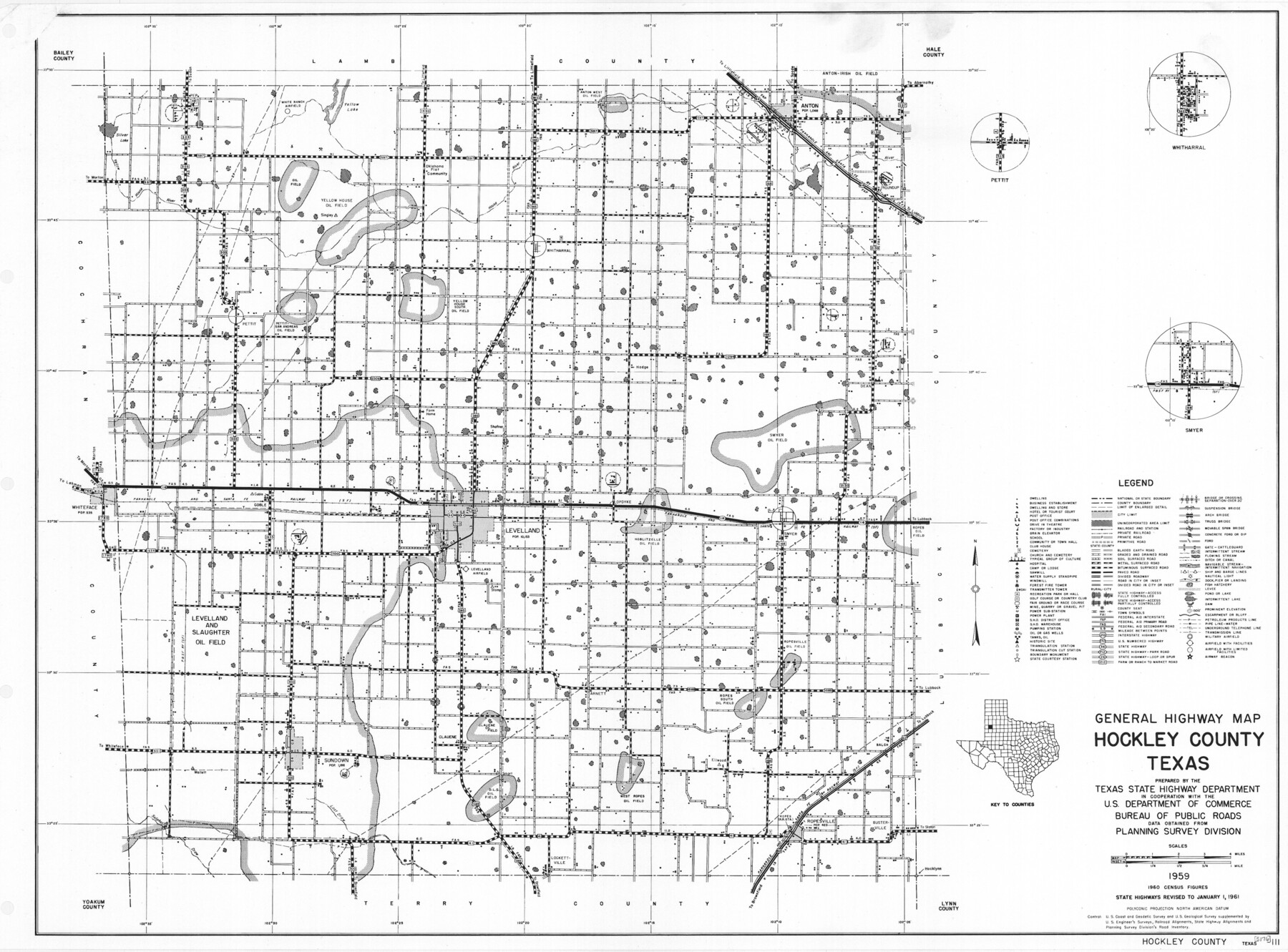
General Highway Map, Hockley County, Texas
-
Map/Doc
79522
-
Collection
Texas State Library and Archives
-
Object Dates
1961 (Creation Date)
-
People and Organizations
Texas State Highway Department (Publisher)
-
Counties
Hockley
-
Subjects
County
-
Height x Width
18.2 x 24.6 inches
46.2 x 62.5 cm
-
Comments
Prints available courtesy of the Texas State Library and Archives.
More info can be found here: TSLAC Map 05176
Part of: Texas State Library and Archives
General Highway Map, Burleson County, Texas

Print $20.00
General Highway Map, Burleson County, Texas
1961
Size 18.1 x 24.8 inches
Map/Doc 79391
General Highway Map. Detail of Cities and Towns in Tarrant County, Texas [Fort Worth and vicinity]
![79253, General Highway Map. Detail of Cities and Towns in Tarrant County, Texas [Fort Worth and vicinity], Texas State Library and Archives](https://historictexasmaps.com/wmedia_w700/maps/79253-GC.tif.jpg)
Print $20.00
General Highway Map. Detail of Cities and Towns in Tarrant County, Texas [Fort Worth and vicinity]
1940
Size 24.8 x 18.4 inches
Map/Doc 79253
General Highway Map, Bexar County, Texas

Print $20.00
General Highway Map, Bexar County, Texas
1961
Size 18.4 x 25.0 inches
Map/Doc 79370
Official Highway Map of Texas

Print $20.00
Official Highway Map of Texas
1928
Size 42.3 x 46.2 inches
Map/Doc 79746
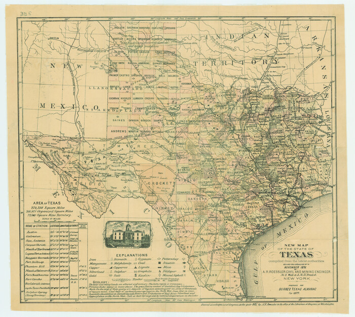
New Map of the State of Texas compiled from the latest authorities
Print $20.00
New Map of the State of Texas compiled from the latest authorities
1877
Size 19.1 x 21.4 inches
Map/Doc 79300
General Highway Map, Mitchell County, Texas

Print $20.00
General Highway Map, Mitchell County, Texas
1940
Size 18.5 x 24.8 inches
Map/Doc 79200
General Highway Map, Fisher County, Texas

Print $20.00
General Highway Map, Fisher County, Texas
1940
Size 18.5 x 25.0 inches
Map/Doc 79090
Map of Texas with Parts of the Adjoining States

Print $20.00
Map of Texas with Parts of the Adjoining States
1836
Size 29.5 x 23.6 inches
Map/Doc 76193
General Highway Map, Palo Pinto County, Texas

Print $20.00
General Highway Map, Palo Pinto County, Texas
1940
Size 18.2 x 24.6 inches
Map/Doc 79213
General Highway Map. Detail of Cities of Towns in Bosque County, Texas

Print $20.00
General Highway Map. Detail of Cities of Towns in Bosque County, Texas
1961
Size 18.2 x 24.9 inches
Map/Doc 79379
General Highway Map, Hutchinson County, Texas

Print $20.00
General Highway Map, Hutchinson County, Texas
1961
Size 18.1 x 24.6 inches
Map/Doc 79529
General Highway Map, Kerr County, Texas

Print $20.00
General Highway Map, Kerr County, Texas
1940
Size 25.0 x 18.4 inches
Map/Doc 79158
You may also like
Map of Tyler County

Print $20.00
- Digital $50.00
Map of Tyler County
1897
Size 42.2 x 39.2 inches
Map/Doc 63081
Chambers County Working Sketch 24

Print $20.00
- Digital $50.00
Chambers County Working Sketch 24
1980
Size 17.5 x 32.3 inches
Map/Doc 68007
Record of Spanish Titles, Vol. III

Record of Spanish Titles, Vol. III
1845
Size 18.2 x 11.9 inches
Map/Doc 94528
Chambers County Sketch File 51

Print $35.00
- Digital $50.00
Chambers County Sketch File 51
1935
Size 14.3 x 9.0 inches
Map/Doc 18068
Schleicher County Sketch File 13

Print $10.00
- Digital $50.00
Schleicher County Sketch File 13
1916
Size 14.4 x 8.9 inches
Map/Doc 36493
Ward County Working Sketch 2

Print $20.00
- Digital $50.00
Ward County Working Sketch 2
1937
Size 22.9 x 28.7 inches
Map/Doc 72308
Moore County Working Sketch 10

Print $20.00
- Digital $50.00
Moore County Working Sketch 10
1951
Size 34.9 x 31.5 inches
Map/Doc 71192
Knox County Working Sketch 13

Print $3.00
- Digital $50.00
Knox County Working Sketch 13
1953
Size 9.6 x 11.0 inches
Map/Doc 70255
Kansas and Nebraska

Print $20.00
- Digital $50.00
Kansas and Nebraska
Size 30.8 x 19.4 inches
Map/Doc 93994
Official Copy of the Map of Milam County made for the International and G. N. R. R. Co.

Print $20.00
- Digital $50.00
Official Copy of the Map of Milam County made for the International and G. N. R. R. Co.
1877
Size 23.9 x 22.5 inches
Map/Doc 581
Working Sketch in Eastland Co.

Print $20.00
- Digital $50.00
Working Sketch in Eastland Co.
1918
Size 12.2 x 17.1 inches
Map/Doc 90881
Pecos County Rolled Sketch 22

Print $20.00
- Digital $50.00
Pecos County Rolled Sketch 22
1886
Size 22.5 x 39.5 inches
Map/Doc 9687