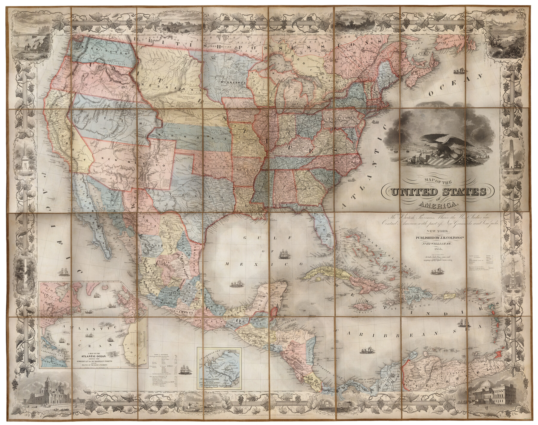
Map of the United States of America, the British Provinces, Mexico, the West Indies and Central America with part of New Granada and Venezuela
[Inset:] A Map of the Atlantic Ocean showing the American and European ports and the routes of the ocean steamers
-
Map/Doc
93904
-
Collection
Holcomb Digital Map Collection
-
Object Dates
1855 (Creation Date)
-
People and Organizations
J. H. Colton and Co. (Publisher)
John M. Atwood (Printer)
George W. Colton (Author)
John M. Atwood (Engraver)
W. S. Barnard (Illustrator)
-
Subjects
Mexico United States
-
Height x Width
34.7 x 44.0 inches
88.1 x 111.8 cm
-
Medium
digital image
-
Comments
Courtesy of Frank and Carol Holcomb.
-
URLs
https://medium.com/save-texas-history/map-of-the-united-states-of-america-the-british-provinces-mexico-the-west-indies-and-central-e9615be9841f#.rx4fdma9p
Part of: Holcomb Digital Map Collection
North America and the West Indies

Print $20.00
- Digital $50.00
North America and the West Indies
1763
Size 41.6 x 46.9 inches
Map/Doc 93834
Traveller's Map of the State of Texas

Print $20.00
- Digital $50.00
Traveller's Map of the State of Texas
1867
Size 43.4 x 41.6 inches
Map/Doc 93906
Map of the State of Coahuila and Texas

Print $20.00
- Digital $50.00
Map of the State of Coahuila and Texas
1834
Size 13.2 x 14.7 inches
Map/Doc 93848
Trace d'une partie Chemin de Fer de Galveston à Houston et Henderson, Texas, Etats unis d'Amérique

Print $20.00
- Digital $50.00
Trace d'une partie Chemin de Fer de Galveston à Houston et Henderson, Texas, Etats unis d'Amérique
1857
Size 17.1 x 21.8 inches
Map/Doc 93905
A New Map of Texas with the Contiguous American & Mexican States

Print $20.00
- Digital $50.00
A New Map of Texas with the Contiguous American & Mexican States
1837
Size 12.5 x 15.1 inches
Map/Doc 96643
Die Neüwen Inseln / so hinder Hispanien gegen Orient bey dem Landt Indie ligen

Print $20.00
- Digital $50.00
Die Neüwen Inseln / so hinder Hispanien gegen Orient bey dem Landt Indie ligen
1540
Size 12.3 x 15.6 inches
Map/Doc 93803
America with those known parts in that unknowne worlde both people and manner of buildings

Print $20.00
- Digital $50.00
America with those known parts in that unknowne worlde both people and manner of buildings
1626
Size 17.2 x 22.3 inches
Map/Doc 93830
Map of Texas to accompany "Brady's Glimpses of Texas"

Print $20.00
- Digital $50.00
Map of Texas to accompany "Brady's Glimpses of Texas"
1871
Size 13.0 x 16.1 inches
Map/Doc 93907
Burlington Route

Print $20.00
- Digital $50.00
Burlington Route
1892
Size 34.9 x 47.7 inches
Map/Doc 93910
A Map of Louisiana and Mexico

Print $20.00
- Digital $50.00
A Map of Louisiana and Mexico
1820
Size 43.8 x 32.9 inches
Map/Doc 94945
A New Map of Texas with the Contiguous American & Mexican States

Print $20.00
- Digital $50.00
A New Map of Texas with the Contiguous American & Mexican States
1835
Size 12.9 x 15.8 inches
Map/Doc 93853

You may also like
Tarrant County Working Sketch Graphic Index

Print $20.00
- Digital $50.00
Tarrant County Working Sketch Graphic Index
1942
Size 44.0 x 35.8 inches
Map/Doc 76708
Midland County Sketch File 8

Print $20.00
- Digital $50.00
Midland County Sketch File 8
1933
Size 17.5 x 21.6 inches
Map/Doc 12084
Flight Mission No. DQO-2K, Frame 140, Galveston County

Print $20.00
- Digital $50.00
Flight Mission No. DQO-2K, Frame 140, Galveston County
1952
Size 18.8 x 22.5 inches
Map/Doc 85037
Flight Mission No. BQY-4M, Frame 37, Harris County

Print $20.00
- Digital $50.00
Flight Mission No. BQY-4M, Frame 37, Harris County
1953
Size 18.6 x 22.3 inches
Map/Doc 85252
Kinney County Working Sketch 6

Print $20.00
- Digital $50.00
Kinney County Working Sketch 6
1908
Size 19.6 x 23.9 inches
Map/Doc 70188
Marion County Sketch File 6

Print $24.00
- Digital $50.00
Marion County Sketch File 6
Size 9.3 x 7.2 inches
Map/Doc 30570
[Surveys in the vicinity of Falls County School Land]
![90168, [Surveys in the vicinity of Falls County School Land], Twichell Survey Records](https://historictexasmaps.com/wmedia_w700/maps/90168-1.tif.jpg)
Print $20.00
- Digital $50.00
[Surveys in the vicinity of Falls County School Land]
Size 32.5 x 37.1 inches
Map/Doc 90168
Galveston Entrance

Print $20.00
- Digital $50.00
Galveston Entrance
1856
Size 16.4 x 20.3 inches
Map/Doc 69857
Maps of Gulf Intracoastal Waterway, Texas - Sabine River to the Rio Grande and connecting waterways including ship channels

Print $20.00
- Digital $50.00
Maps of Gulf Intracoastal Waterway, Texas - Sabine River to the Rio Grande and connecting waterways including ship channels
1966
Size 14.5 x 22.2 inches
Map/Doc 61928
Map of Texas, compiled from surveys on record in the General Land Office of the Republic to the year 1839

Print $20.00
- Digital $50.00
Map of Texas, compiled from surveys on record in the General Land Office of the Republic to the year 1839
1839
Size 33.1 x 25.8 inches
Map/Doc 93986
Crockett County Rolled Sketch 88E

Print $40.00
- Digital $50.00
Crockett County Rolled Sketch 88E
1973
Size 44.4 x 30.6 inches
Map/Doc 8730
Plat Showing Survey made for J. M. Teague, Jr. Gaines County, Texas

Print $20.00
- Digital $50.00
Plat Showing Survey made for J. M. Teague, Jr. Gaines County, Texas
1956
Size 12.7 x 18.7 inches
Map/Doc 92672