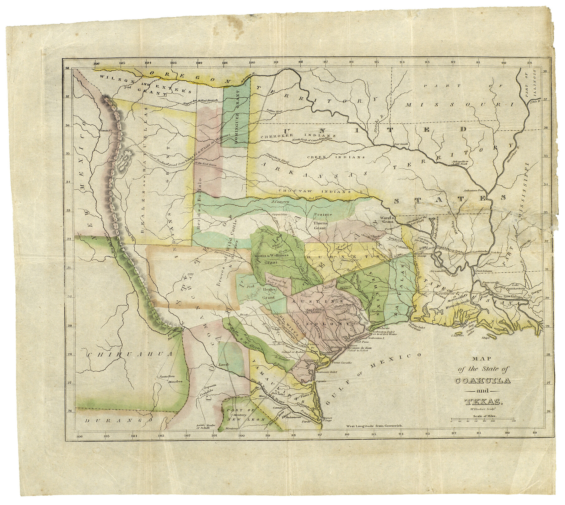
Map of the State of Coahuila and Texas
-
Map/Doc
93848
-
Collection
Holcomb Digital Map Collection
-
Object Dates
1834 (Creation Date)
-
People and Organizations
W. Hooker (Printer)
-
Subjects
Mexican Texas
-
Height x Width
13.2 x 14.7 inches
33.5 x 37.3 cm
-
Comments
From the book: "A Visit to Texas: Being The Journal of a Traveler Through Those Parts Most Interesting to American Settlers. With Descriptions of Scenery, Habits, & c. &c." Courtesy of Frank and Carol Holcomb.
Part of: Holcomb Digital Map Collection

A General Map of North America; In which is Express'd the several New Roads, Forts, Engagements, & c. taken from Actual Surveys and Observations Made in the Army employ'd there

Print $20.00
- Digital $50.00
A General Map of North America; In which is Express'd the several New Roads, Forts, Engagements, & c. taken from Actual Surveys and Observations Made in the Army employ'd there
1761
Size 37.6 x 38.6 inches
Map/Doc 93827
Map of Africa designed to accompany Smith's Geography for Schools

Print $20.00
- Digital $50.00
Map of Africa designed to accompany Smith's Geography for Schools
1850
Size 9.7 x 12.0 inches
Map/Doc 93897
Colton's New Map of the State of Texas, the Indian Territory and adjoining portions of New Mexico, Louisiana and Arkansas

Print $2.00
- Digital $50.00
Colton's New Map of the State of Texas, the Indian Territory and adjoining portions of New Mexico, Louisiana and Arkansas
1882
Size 8.5 x 5.0 inches
Map/Doc 93921
Nova et Acurata Totius Americae Tabula

Print $40.00
Nova et Acurata Totius Americae Tabula
1608
Size 40.8 x 56.5 inches
Map/Doc 97019
Die Neüwen Inseln / so hinder Hispanien gegen Orient bey dem Landt Indie ligen

Print $20.00
- Digital $50.00
Die Neüwen Inseln / so hinder Hispanien gegen Orient bey dem Landt Indie ligen
1540
Size 10.8 x 15.8 inches
Map/Doc 93831

Map of the West Indies designed to accompany Smith's Geography for Schools

Print $20.00
- Digital $50.00
Map of the West Indies designed to accompany Smith's Geography for Schools
1850
Size 9.6 x 12.0 inches
Map/Doc 93893
Il Disegno del discoperto della nova Franza, il quale se havuto ultimamente dalla novissima navigatione dè Francesi in quel luogo

Print $20.00
- Digital $50.00
Il Disegno del discoperto della nova Franza, il quale se havuto ultimamente dalla novissima navigatione dè Francesi in quel luogo
1566
Size 12.6 x 18.6 inches
Map/Doc 93804
Map of Oceanica designed to accompany Smith's Geography for Schools

Print $20.00
- Digital $50.00
Map of Oceanica designed to accompany Smith's Geography for Schools
1850
Size 9.7 x 12.1 inches
Map/Doc 93898

Map of the Western States designed to accompany Smith's Geography for Schools

Print $20.00
- Digital $50.00
Map of the Western States designed to accompany Smith's Geography for Schools
1850
Size 12.2 x 19.1 inches
Map/Doc 93889
You may also like
New Map of State of Texas

Print $20.00
- Digital $50.00
New Map of State of Texas
1881
Size 21.4 x 27.6 inches
Map/Doc 460
Rockwall County Boundary File 8

Print $10.00
- Digital $50.00
Rockwall County Boundary File 8
Size 14.4 x 8.8 inches
Map/Doc 58428
Somervell County Working Sketch 4

Print $20.00
- Digital $50.00
Somervell County Working Sketch 4
1975
Size 38.3 x 29.7 inches
Map/Doc 63908
Johnson County, Texas

Print $20.00
- Digital $50.00
Johnson County, Texas
1871
Size 18.2 x 23.3 inches
Map/Doc 734
Upshur County Sketch File 15

Print $20.00
- Digital $50.00
Upshur County Sketch File 15
1934
Size 20.7 x 31.2 inches
Map/Doc 12505
Mitchell County Sketch File 15

Print $20.00
- Digital $50.00
Mitchell County Sketch File 15
1931
Size 19.2 x 19.6 inches
Map/Doc 12102
Van Zandt County Working Sketch 6a

Print $40.00
- Digital $50.00
Van Zandt County Working Sketch 6a
1941
Size 57.2 x 25.7 inches
Map/Doc 69762
Flight Mission No. CUG-3P, Frame 134, Kleberg County

Print $20.00
- Digital $50.00
Flight Mission No. CUG-3P, Frame 134, Kleberg County
1956
Size 18.5 x 22.3 inches
Map/Doc 86269
Eastland County Working Sketch 6

Print $20.00
- Digital $50.00
Eastland County Working Sketch 6
1918
Size 17.2 x 11.4 inches
Map/Doc 68787
Webb County Working Sketch 74

Print $20.00
- Digital $50.00
Webb County Working Sketch 74
1975
Size 17.0 x 30.0 inches
Map/Doc 72441
Presidio County Rolled Sketch SM

Print $15.00
- Digital $50.00
Presidio County Rolled Sketch SM
1910
Size 9.5 x 15.0 inches
Map/Doc 48822
