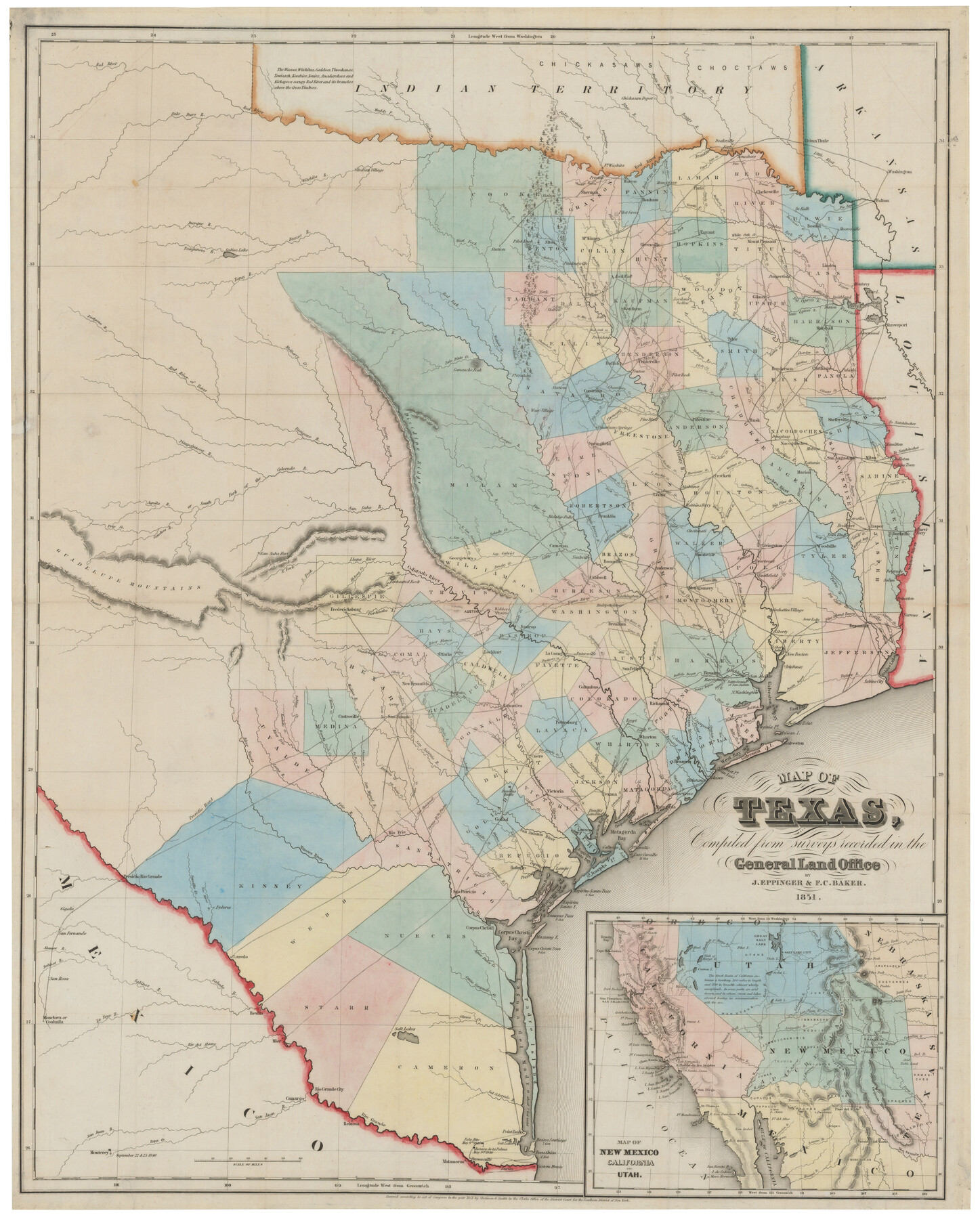
Map of Texas compiled from surveys included in the General Land Office
-
Map/Doc
94417
-
Collection
Holcomb Digital Map Collection
-
Object Dates
1851 (Creation Date)
-
People and Organizations
Sherman & Smith (Publisher)
J. Eppinger (Compiler)
F.C. Baker (Compiler)
-
Subjects
State of Texas
-
Height x Width
31.4 x 25.3 inches
79.8 x 64.3 cm
-
Medium
digital image
Part of: Holcomb Digital Map Collection
Mapa de los Estados Unidos Mejicanos arreglado a la distribucion que en diversos decretos ha hecho del territorio el Congreso General Mejicano

Print $20.00
- Digital $50.00
Mapa de los Estados Unidos Mejicanos arreglado a la distribucion que en diversos decretos ha hecho del territorio el Congreso General Mejicano
1837
Size 24.3 x 29.4 inches
Map/Doc 96515
The History of Texas; or, the Emigrants, Farmer's, and Politician's Guide to the Character, Climate, Soil and Productions of that Country; geographically arranged from personal observation and experience.

Print $692.00
- Digital $50.00
The History of Texas; or, the Emigrants, Farmer's, and Politician's Guide to the Character, Climate, Soil and Productions of that Country; geographically arranged from personal observation and experience.
1836
Size 8.1 x 5.3 inches
Map/Doc 93856
Map of the United States of America with its territories and districts including also a part of upper and lower Canada and Mexico

Print $20.00
- Digital $50.00
Map of the United States of America with its territories and districts including also a part of upper and lower Canada and Mexico
1835
Size 31.3 x 44.7 inches
Map/Doc 93852
Map of Texas with parts of the Adjoining States

Print $20.00
- Digital $50.00
Map of Texas with parts of the Adjoining States
1830
Size 29.6 x 24.1 inches
Map/Doc 94440
Map of North America designed to accompany Smith's Geography for Schools

Print $20.00
- Digital $50.00
Map of North America designed to accompany Smith's Geography for Schools
1850
Size 12.0 x 9.9 inches
Map/Doc 93883
Map of the State of Texas from the Latest Authorities

Print $20.00
- Digital $50.00
Map of the State of Texas from the Latest Authorities
1854
Size 13.1 x 16.1 inches
Map/Doc 93901
Map of the United States and Canada designed to accompany Smith's Geography for Schools

Print $20.00
- Digital $50.00
Map of the United States and Canada designed to accompany Smith's Geography for Schools
1850
Size 12.1 x 19.2 inches
Map/Doc 93884
A new & correct map of Texas compiled from the most recent surveys & authorities to the year 1845

Print $20.00
- Digital $50.00
A new & correct map of Texas compiled from the most recent surveys & authorities to the year 1845
1845
Size 22.4 x 28.5 inches
Map/Doc 96973

Carte de la Nouvelle France ou le voit le cours des Grandes Rivieres de S. Laurens & de Mississipi

Print $20.00
- Digital $50.00
Carte de la Nouvelle France ou le voit le cours des Grandes Rivieres de S. Laurens & de Mississipi
1720
Size 25.9 x 41.5 inches
Map/Doc 93822
Nova Totivs Americae Descriptio

Print $20.00
- Digital $50.00
Nova Totivs Americae Descriptio
1666
Size 21.2 x 24.3 inches
Map/Doc 93818
Carte Generale du Royaume de la Nouvelle Espagne depuis le Parallele de 16° jusqu'au Parallele de 38° (Latitude Nord)

Print $20.00
- Digital $50.00
Carte Generale du Royaume de la Nouvelle Espagne depuis le Parallele de 16° jusqu'au Parallele de 38° (Latitude Nord)
1804
Size 41.5 x 29.5 inches
Map/Doc 96510
You may also like
[Runnels County School Land and vicinity]
![91686, [Runnels County School Land and vicinity], Twichell Survey Records](https://historictexasmaps.com/wmedia_w700/maps/91686-1.tif.jpg)
Print $20.00
- Digital $50.00
[Runnels County School Land and vicinity]
1945
Size 17.9 x 12.5 inches
Map/Doc 91686
Ward County Rolled Sketch 10

Print $20.00
- Digital $50.00
Ward County Rolled Sketch 10
1936
Size 24.4 x 35.7 inches
Map/Doc 8155
Intracoastal Waterway in Texas - Corpus Christi to Point Isabel including Arroyo Colorado to Mo. Pac. R.R. Bridge Near Harlingen

Print $20.00
- Digital $50.00
Intracoastal Waterway in Texas - Corpus Christi to Point Isabel including Arroyo Colorado to Mo. Pac. R.R. Bridge Near Harlingen
1933
Size 27.8 x 40.9 inches
Map/Doc 61864
Terrell County Rolled Sketch 52

Print $20.00
- Digital $50.00
Terrell County Rolled Sketch 52
1967
Size 26.8 x 30.5 inches
Map/Doc 7970
Chambers County NRC Article 33.136 Sketch 3

Print $21.00
- Digital $50.00
Chambers County NRC Article 33.136 Sketch 3
2005
Size 25.0 x 36.8 inches
Map/Doc 83595
Winkler County Rolled Sketch 14

Print $20.00
- Digital $50.00
Winkler County Rolled Sketch 14
Size 25.9 x 38.4 inches
Map/Doc 8275

Mitchell County Sketch File 9

Print $8.00
- Digital $50.00
Mitchell County Sketch File 9
1909
Size 11.4 x 8.6 inches
Map/Doc 31694
Cooke County Rolled Sketch 3

Print $20.00
- Digital $50.00
Cooke County Rolled Sketch 3
1944
Size 37.1 x 40.2 inches
Map/Doc 8670
Bell County Sketch File 18

Print $4.00
- Digital $50.00
Bell County Sketch File 18
1870
Size 7.9 x 9.0 inches
Map/Doc 14400
Matagorda Light to Aransas Pass

Print $20.00
- Digital $50.00
Matagorda Light to Aransas Pass
1934
Size 35.3 x 44.3 inches
Map/Doc 73392
Jeff Davis County Sketch File 1

Print $20.00
- Digital $50.00
Jeff Davis County Sketch File 1
Size 35.8 x 24.2 inches
Map/Doc 11855