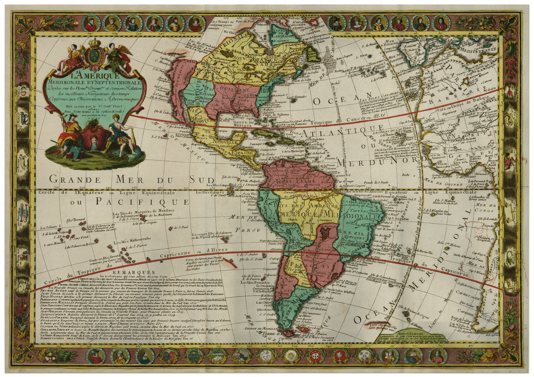
L'Amerique Meridionale et Septentrionale
-
Map/Doc
93825
-
Collection
Holcomb Digital Map Collection
-
Object Dates
1731 (Creation Date)
-
People and Organizations
Guillaume Danet (Author)
-
Subjects
North America
-
Height x Width
20.0 x 28.3 inches
50.8 x 71.9 cm
-
Comments
Courtesy of Frank and Carol Holcomb.
Part of: Holcomb Digital Map Collection
Map of the United States with the contiguous British & Spanish Possessions compiled from the latest & best authorities

Print $40.00
- Digital $50.00
Map of the United States with the contiguous British & Spanish Possessions compiled from the latest & best authorities
1818
Size 36.9 x 59.5 inches
Map/Doc 93843
Tabula Terre Nove

Print $20.00
- Digital $50.00
Tabula Terre Nove
1513
Size 18.7 x 24.6 inches
Map/Doc 93800
Amerique Septentrionale divisée en ses principales parties

Print $20.00
- Digital $50.00
Amerique Septentrionale divisée en ses principales parties
1792
Size 21.3 x 25.9 inches
Map/Doc 93916
Americae Sive Novi Orbis Nova Descriptio

Print $20.00
- Digital $50.00
Americae Sive Novi Orbis Nova Descriptio
1606
Size 16.5 x 22.4 inches
Map/Doc 93810
Brady's Glimpses of Texas with maps

Print $216.00
- Digital $50.00
Brady's Glimpses of Texas with maps
1871
Size 7.5 x 4.9 inches
Map/Doc 93918
Mapa de los Estados Unidos de Méjico, Segun lo organizado y definido por las varias actas del Congreso de dicha Republica: y construido por las mejores autoridades

Print $20.00
- Digital $50.00
Mapa de los Estados Unidos de Méjico, Segun lo organizado y definido por las varias actas del Congreso de dicha Republica: y construido por las mejores autoridades
1828
Size 29.1 x 41.6 inches
Map/Doc 93846
Terre Nove (verso)

Print $20.00
- Digital $50.00
Terre Nove (verso)
1522
Size 12.2 x 7.8 inches
Map/Doc 93802
Map of the Texas & Pacific Railway and connections

Print $20.00
- Digital $50.00
Map of the Texas & Pacific Railway and connections
1902
Size 18.0 x 36.8 inches
Map/Doc 95413
A Visit to Texas: Being The Journal of a Traveler Through Those Parts Most Interesting to American Settlers. With Descriptions of Scenery, Habits, & c. &c.

Print $560.00
- Digital $50.00
A Visit to Texas: Being The Journal of a Traveler Through Those Parts Most Interesting to American Settlers. With Descriptions of Scenery, Habits, & c. &c.
1834
Size 8.0 x 5.2 inches
Map/Doc 93849
Bowles's New Pocket Map of America divided into its Provinces, Colonies, States, Governments &c. exhibiting the British and Spanish Empires therein; together with the Territories belonging to the French, Dutch, Danes & Portuguese

Print $20.00
- Digital $50.00
Bowles's New Pocket Map of America divided into its Provinces, Colonies, States, Governments &c. exhibiting the British and Spanish Empires therein; together with the Territories belonging to the French, Dutch, Danes & Portuguese
1784
Size 21.3 x 23.1 inches
Map/Doc 93838
Novissima et Accuratissima Totius Americae Descriptio

Print $20.00
- Digital $50.00
Novissima et Accuratissima Totius Americae Descriptio
1677
Size 20.9 x 25.0 inches
Map/Doc 93819
Karte des Staates Texas (aufgenommen in die Union 1846) nach der neuesten Eintheilung

Print $20.00
- Digital $50.00
Karte des Staates Texas (aufgenommen in die Union 1846) nach der neuesten Eintheilung
1849
Size 13.6 x 15.3 inches
Map/Doc 93880
You may also like

Map of Motley County

Print $20.00
- Digital $50.00
Map of Motley County
1902
Size 43.4 x 37.7 inches
Map/Doc 10799
Map of Galveston, Harrisburg & San Antonio Railway in Pecos County

Print $40.00
- Digital $50.00
Map of Galveston, Harrisburg & San Antonio Railway in Pecos County
1888
Size 26.0 x 80.9 inches
Map/Doc 64399

Stonewall County

Print $20.00
- Digital $50.00
Stonewall County
1933
Size 47.6 x 39.5 inches
Map/Doc 73295
[Map of Oldham County]
![91456, [Map of Oldham County], Twichell Survey Records](https://historictexasmaps.com/wmedia_w700/maps/91456-1.tif.jpg)
Print $20.00
- Digital $50.00
[Map of Oldham County]
Size 28.4 x 20.5 inches
Map/Doc 91456
Brazoria County Sketch File 23

Print $40.00
- Digital $50.00
Brazoria County Sketch File 23
Size 12.7 x 12.2 inches
Map/Doc 15020
Crockett County Working Sketch 37

Print $20.00
- Digital $50.00
Crockett County Working Sketch 37
1927
Size 30.5 x 24.4 inches
Map/Doc 68370
Floyd County Boundary File 1a

Print $40.00
- Digital $50.00
Floyd County Boundary File 1a
Size 9.2 x 37.4 inches
Map/Doc 53460
King County Boundary File 1

Print $46.00
- Digital $50.00
King County Boundary File 1
Size 14.2 x 8.6 inches
Map/Doc 64873
Henderson County Sketch File 14

Print $4.00
- Digital $50.00
Henderson County Sketch File 14
1889
Size 10.7 x 7.3 inches
Map/Doc 26355
Matagorda County Sketch File 3

Print $4.00
- Digital $50.00
Matagorda County Sketch File 3
1876
Size 12.9 x 8.0 inches
Map/Doc 30732