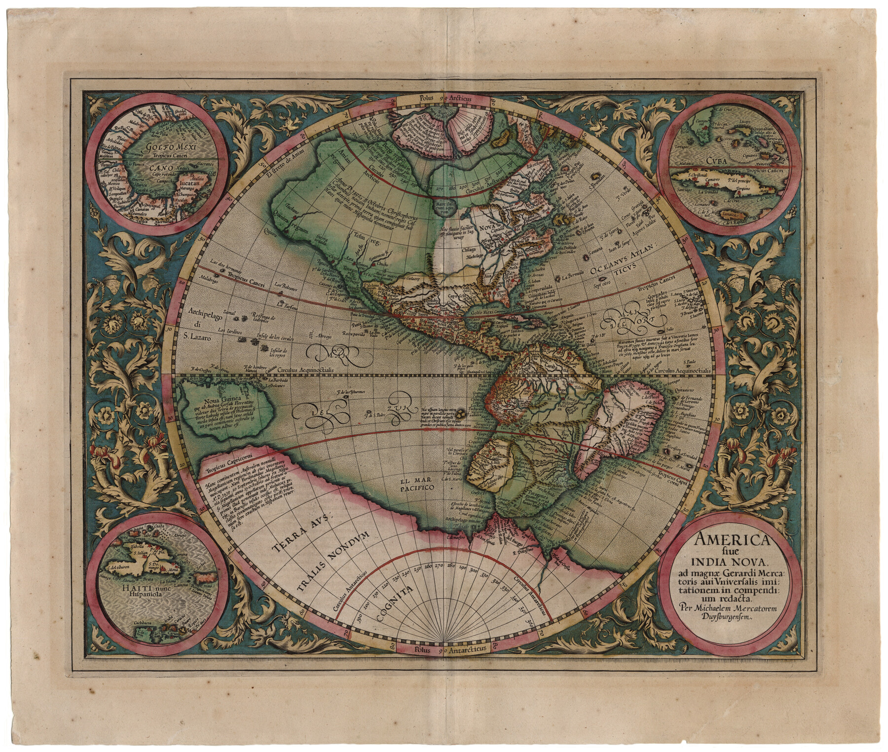
America siue India Nova ad magnae Gerardi Mercatoris aui Vniversalis imitationem in compendium redacta
-
Map/Doc
93807
-
Collection
Holcomb Digital Map Collection
-
Object Dates
1595 (Creation Date)
-
People and Organizations
Michael Mercator (Author)
-
Subjects
North America South America
-
Height x Width
18.3 x 21.6 inches
46.5 x 54.9 cm
-
Comments
Courtesy of Frank and Carol Holcomb.
Part of: Holcomb Digital Map Collection
A Map of the Internal Provinces of New Spain

Print $20.00
- Digital $50.00
A Map of the Internal Provinces of New Spain
1807
Size 20.9 x 20.0 inches
Map/Doc 97239
Bird's Eye View of the City of Houston, Texas

Print $20.00
- Digital $50.00
Bird's Eye View of the City of Houston, Texas
1873
Size 25.2 x 31.5 inches
Map/Doc 93908
Map of South America designed to accompany Smith's Geography of Schools

Print $20.00
- Digital $50.00
Map of South America designed to accompany Smith's Geography of Schools
1850
Size 12.0 x 9.8 inches
Map/Doc 93891
The Scarborough Company's New Railroad, Post Office & County Map of Texas, Oklahoma and Indian Territory Compiled from the Latest Government Surveys and Original Sources

Print $20.00
- Digital $50.00
The Scarborough Company's New Railroad, Post Office & County Map of Texas, Oklahoma and Indian Territory Compiled from the Latest Government Surveys and Original Sources
1904
Size 42.8 x 46.6 inches
Map/Doc 93911
Carte de la Louisiane et du Cours du Mississipi

Print $20.00
- Digital $50.00
Carte de la Louisiane et du Cours du Mississipi
1718
Size 20.6 x 27.3 inches
Map/Doc 93821
Karte von Texas

Print $20.00
- Digital $50.00
Karte von Texas
1846
Size 18.9 x 14.6 inches
Map/Doc 93875
Map of the United States and Canada

Print $2.00
- Digital $50.00
Map of the United States and Canada
1853
Size 6.2 x 4.2 inches
Map/Doc 93919
Carte d'Amerique, Divisee en ses Principaux Pays, Dressee sur les Memoires les plus recents, et sur differents Voyages, et assujettie aux observations Astronomiques de Mrs. de l'Academie Royale des Sciences

Print $40.00
- Digital $50.00
Carte d'Amerique, Divisee en ses Principaux Pays, Dressee sur les Memoires les plus recents, et sur differents Voyages, et assujettie aux observations Astronomiques de Mrs. de l'Academie Royale des Sciences
1787
Size 43.5 x 51.3 inches
Map/Doc 96430
A New Map of Texas with the Contiguous American & Mexican States

Print $20.00
- Digital $50.00
A New Map of Texas with the Contiguous American & Mexican States
1837
Size 12.5 x 15.1 inches
Map/Doc 96643
A Map of the United States of Mexico as organized and defined by the several Acts of the Congress of that Republic

Print $20.00
- Digital $50.00
A Map of the United States of Mexico as organized and defined by the several Acts of the Congress of that Republic
1847
Size 24.3 x 30.6 inches
Map/Doc 93876
Map of the United States of America with its territories and districts including also a part of upper and lower Canada and Mexico

Print $20.00
- Digital $50.00
Map of the United States of America with its territories and districts including also a part of upper and lower Canada and Mexico
1835
Size 31.3 x 44.7 inches
Map/Doc 93852
Carte du Mexique et de la Floride des Terres Angloises et des Isles Antilles du cours et des environs de la Riviere de Mississipi

Print $20.00
- Digital $50.00
Carte du Mexique et de la Floride des Terres Angloises et des Isles Antilles du cours et des environs de la Riviere de Mississipi
1703
Size 19.0 x 25.8 inches
Map/Doc 96519
You may also like
Kerr County Working Sketch 35

Print $20.00
- Digital $50.00
Kerr County Working Sketch 35
1981
Size 35.2 x 15.5 inches
Map/Doc 70066
Kinney County Rolled Sketch 17

Print $20.00
- Digital $50.00
Kinney County Rolled Sketch 17
1965
Size 18.4 x 21.5 inches
Map/Doc 6544
Flight Mission No. BRA-17M, Frame 13, Jefferson County

Print $20.00
- Digital $50.00
Flight Mission No. BRA-17M, Frame 13, Jefferson County
1953
Size 18.6 x 22.3 inches
Map/Doc 85794
Harris County Working Sketch 10

Print $20.00
- Digital $50.00
Harris County Working Sketch 10
1912
Size 25.7 x 18.1 inches
Map/Doc 65902
Flight Mission No. DIX-5P, Frame 139, Aransas County

Print $20.00
- Digital $50.00
Flight Mission No. DIX-5P, Frame 139, Aransas County
1956
Size 17.6 x 17.8 inches
Map/Doc 83800
Texas Official Highway Travel Map

Texas Official Highway Travel Map
Size 27.4 x 36.3 inches
Map/Doc 94307
Amistad International Reservoir on Rio Grande 78a

Print $20.00
- Digital $50.00
Amistad International Reservoir on Rio Grande 78a
1949
Size 28.5 x 40.1 inches
Map/Doc 75507
Burleson County Working Sketch 44

Print $20.00
- Digital $50.00
Burleson County Working Sketch 44
1991
Size 22.4 x 25.0 inches
Map/Doc 67763
Angelina County Sketch File 27

Print $10.00
- Digital $50.00
Angelina County Sketch File 27
1890
Size 14.1 x 8.7 inches
Map/Doc 13073
Gregg County Rolled Sketch 15

Print $40.00
- Digital $50.00
Gregg County Rolled Sketch 15
1941
Size 42.7 x 57.1 inches
Map/Doc 9066
Polk County Sketch File 13

Print $4.00
- Digital $50.00
Polk County Sketch File 13
Size 5.1 x 7.4 inches
Map/Doc 34150
Township No. 4 South Range No. 15 West of the Indian Meridian

Print $4.00
- Digital $50.00
Township No. 4 South Range No. 15 West of the Indian Meridian
1875
Size 17.9 x 22.4 inches
Map/Doc 75151