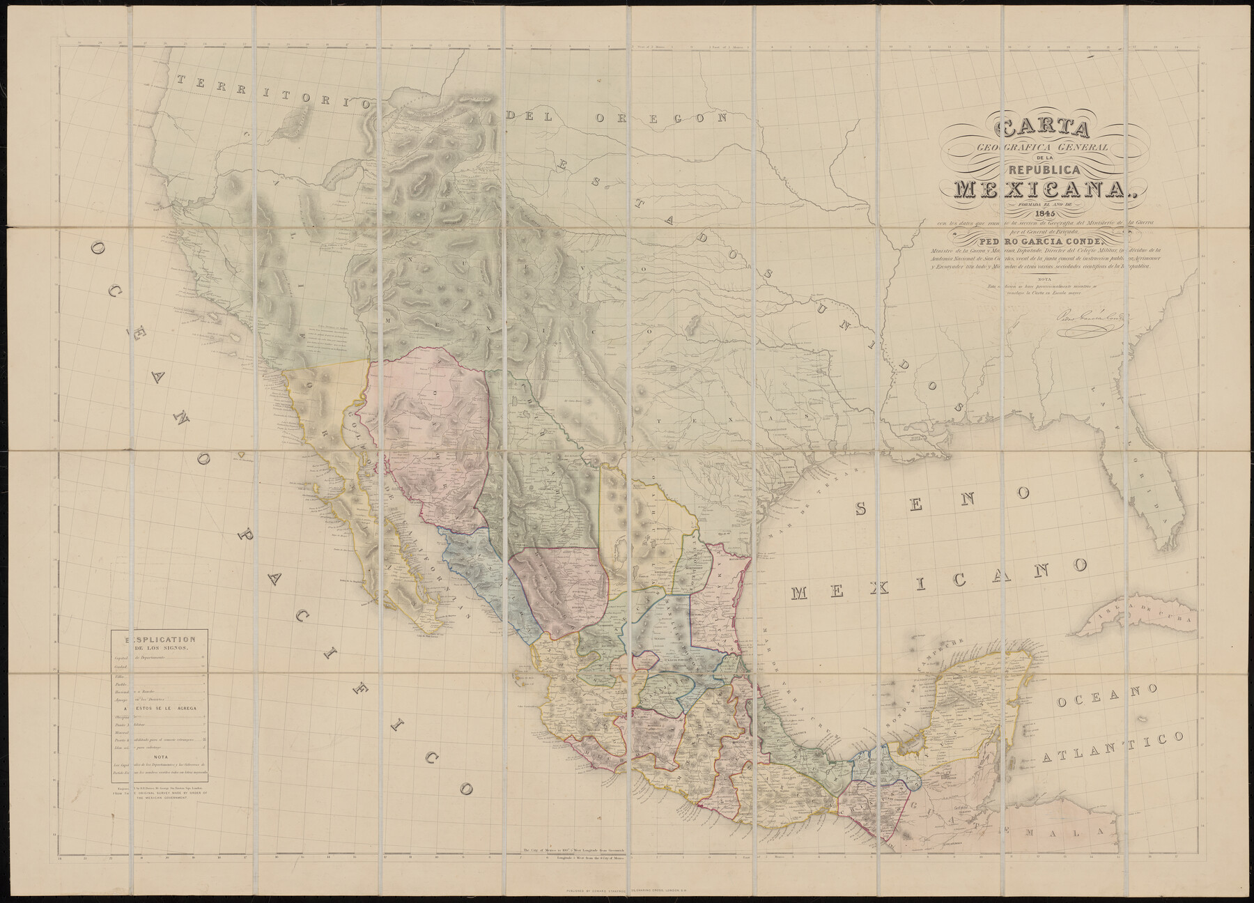
Carta Geografica General de la Republica Mexicana
-
Map/Doc
96438
-
Collection
Holcomb Digital Map Collection
-
Object Dates
1845 (Creation Date)
-
People and Organizations
Edward Stanford (Publisher)
Pedro Garcia Conde (Cartographer)
-
Subjects
Mexico United States
-
Height x Width
38.1 x 52.9 inches
96.8 x 134.4 cm
-
Medium
digital image
-
Comments
Courtesy of Frank and Carol Holcomb.
To view image of box in which this map was originally folded, click "Download PDF" link above.
Part of: Holcomb Digital Map Collection
Map of the Western States designed to accompany Smith's Geography for Schools

Print $20.00
- Digital $50.00
Map of the Western States designed to accompany Smith's Geography for Schools
1850
Size 12.2 x 19.1 inches
Map/Doc 93889
Tanner's Travelling Map of Mexico

Print $2.00
- Digital $50.00
Tanner's Travelling Map of Mexico
1847
Size 6.2 x 4.1 inches
Map/Doc 93877
Mapa de los Estados Unidos de Méjico, Segun lo organizado y definido por las varias actas del Congreso de dicha Republica: y construido por las mejores autoridades

Print $20.00
- Digital $50.00
Mapa de los Estados Unidos de Méjico, Segun lo organizado y definido por las varias actas del Congreso de dicha Republica: y construido por las mejores autoridades
1847
Size 31.3 x 42.3 inches
Map/Doc 93878
America with those known parts in that unknowne worlde both people and manner of buildings

Print $20.00
- Digital $50.00
America with those known parts in that unknowne worlde both people and manner of buildings
1626
Size 17.2 x 22.3 inches
Map/Doc 93830
J. De Cordova's Map of the State of Texas Compiled from the records of the General Land Office of the State

Print $20.00
- Digital $50.00
J. De Cordova's Map of the State of Texas Compiled from the records of the General Land Office of the State
1849
Size 33.7 x 36.1 inches
Map/Doc 94026
Map of Asia designed to accompany Smith's Geography for Schools

Print $20.00
- Digital $50.00
Map of Asia designed to accompany Smith's Geography for Schools
1850
Size 9.6 x 12.0 inches
Map/Doc 93896
Map of the Middle States designed to accompany Smith's Geography for Schools

Print $20.00
- Digital $50.00
Map of the Middle States designed to accompany Smith's Geography for Schools
1850
Size 19.4 x 12.2 inches
Map/Doc 93887
Texas Nach den besten Quellen

Print $20.00
- Digital $50.00
Texas Nach den besten Quellen
1846
Size 15.4 x 18.7 inches
Map/Doc 93874
The North Part of America

Print $20.00
- Digital $50.00
The North Part of America
1625
Size 13.1 x 14.8 inches
Map/Doc 93815
Bird's Eye View of the City of Houston, Texas

Print $20.00
- Digital $50.00
Bird's Eye View of the City of Houston, Texas
1873
Size 25.2 x 31.5 inches
Map/Doc 93908
Mexico and Internal Provinces

Print $20.00
- Digital $50.00
Mexico and Internal Provinces
1829
Size 13.6 x 15.3 inches
Map/Doc 96971
Map of the Southern part of Texas

Print $20.00
- Digital $50.00
Map of the Southern part of Texas
1831
Size 17.5 x 21.3 inches
Map/Doc 94442
You may also like

[Surveys Surrounding I. G. Yates S.F. 12394]
![91577, [Surveys Surrounding I. G. Yates S.F. 12394], Twichell Survey Records](https://historictexasmaps.com/wmedia_w700/maps/91577-1.tif.jpg)
Print $20.00
- Digital $50.00
[Surveys Surrounding I. G. Yates S.F. 12394]
Size 18.6 x 7.2 inches
Map/Doc 91577
[Block O1, Godair]
![90566, [Block O1, Godair], Twichell Survey Records](https://historictexasmaps.com/wmedia_w700/maps/90566-1.tif.jpg)
Print $20.00
- Digital $50.00
[Block O1, Godair]
Size 22.7 x 18.0 inches
Map/Doc 90566

Crockett County Sketch File 63

Print $4.00
- Digital $50.00
Crockett County Sketch File 63
1927
Size 11.0 x 8.8 inches
Map/Doc 19851

Amistad International Reservoir on Rio Grande 62

Print $20.00
- Digital $50.00
Amistad International Reservoir on Rio Grande 62
1949
Size 28.2 x 39.6 inches
Map/Doc 73347
[Blocks O3 and O4 and Capitol Leagues in the vicinity]
![90391, [Blocks O3 and O4 and Capitol Leagues in the vicinity], Twichell Survey Records](https://historictexasmaps.com/wmedia_w700/maps/90391-1.tif.jpg)
Print $2.00
- Digital $50.00
[Blocks O3 and O4 and Capitol Leagues in the vicinity]
Size 8.4 x 10.5 inches
Map/Doc 90391
Upton County Sketch File 8

Print $4.00
- Digital $50.00
Upton County Sketch File 8
1913
Size 14.4 x 8.8 inches
Map/Doc 38822
Current Miscellaneous File 86

Print $6.00
- Digital $50.00
Current Miscellaneous File 86
Size 11.2 x 8.8 inches
Map/Doc 74240
Flight Mission No. CUG-2P, Frame 21, Kleberg County

Print $20.00
- Digital $50.00
Flight Mission No. CUG-2P, Frame 21, Kleberg County
1956
Size 18.5 x 22.3 inches
Map/Doc 86185
Shelby County Working Sketch 9

Print $20.00
- Digital $50.00
Shelby County Working Sketch 9
1945
Size 30.8 x 28.5 inches
Map/Doc 63862