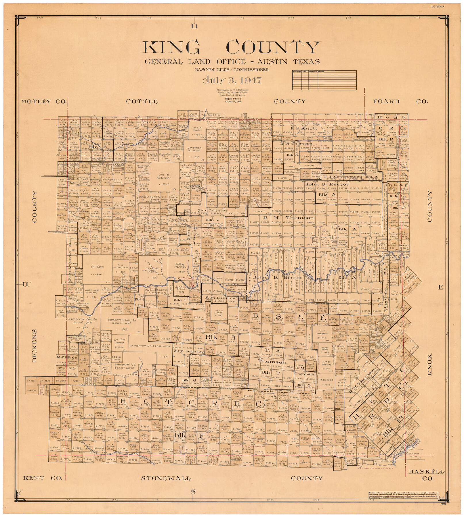
King County
General Land Office Official County Map
-
Map/Doc
95558
-
Collection
General Map Collection
-
Object Dates
2019/8/31 (Revision Date)
1947/7/3 (Creation Date)
-
People and Organizations
Cheyenne Betancourt (Draftsman)
Tommye Buie (Draftsman)
Victor E. Sterzing (Compiler)
Bascom Giles (GLO Commissioner)
-
Counties
King
-
Subjects
County OCM
-
Height x Width
45.6 x 41.2 inches
115.8 x 104.6 cm
-
Medium
digital image
-
Scale
1" = 2000 varas
Part of: General Map Collection
Texas 1973 Official Highway Travel Map

Texas 1973 Official Highway Travel Map
Size 28.1 x 36.3 inches
Map/Doc 94406
Tom Green County Rolled Sketch 9

Print $20.00
- Digital $50.00
Tom Green County Rolled Sketch 9
1949
Size 32.2 x 41.0 inches
Map/Doc 9999
Freestone County Working Sketch 18

Print $20.00
- Digital $50.00
Freestone County Working Sketch 18
1980
Size 43.3 x 46.9 inches
Map/Doc 69260
Armstrong County

Print $20.00
- Digital $50.00
Armstrong County
1933
Size 43.2 x 41.2 inches
Map/Doc 95420
Bastrop County

Print $20.00
- Digital $50.00
Bastrop County
1879
Size 21.5 x 19.5 inches
Map/Doc 3277
Flight Mission No. DIX-8P, Frame 65, Aransas County

Print $20.00
- Digital $50.00
Flight Mission No. DIX-8P, Frame 65, Aransas County
1956
Size 18.7 x 22.4 inches
Map/Doc 83896
[Meanders of a navigable river, perhaps Cow Bayou]
![66, [Meanders of a navigable river, perhaps Cow Bayou], General Map Collection](https://historictexasmaps.com/wmedia_w700/maps/66.tif.jpg)
Print $20.00
- Digital $50.00
[Meanders of a navigable river, perhaps Cow Bayou]
1842
Size 14.0 x 16.6 inches
Map/Doc 66
Presidio County Working Sketch 133

Print $20.00
- Digital $50.00
Presidio County Working Sketch 133
1989
Size 31.7 x 42.8 inches
Map/Doc 71811
Kimble County Working Sketch 28

Print $20.00
- Digital $50.00
Kimble County Working Sketch 28
1938
Size 29.4 x 23.2 inches
Map/Doc 70096
Gulf Coast of the United States, Key West to Rio Grande

Print $20.00
- Digital $50.00
Gulf Coast of the United States, Key West to Rio Grande
1863
Size 18.3 x 27.2 inches
Map/Doc 72667
Motley County Sketch File A (S)

Print $40.00
- Digital $50.00
Motley County Sketch File A (S)
Size 10.7 x 20.4 inches
Map/Doc 32155
Flight Mission No. DAG-18K, Frame 74, Matagorda County

Print $20.00
- Digital $50.00
Flight Mission No. DAG-18K, Frame 74, Matagorda County
1952
Size 18.5 x 22.4 inches
Map/Doc 86367
You may also like
Haskell County Sketch File 4

Print $20.00
- Digital $50.00
Haskell County Sketch File 4
Size 17.7 x 18.6 inches
Map/Doc 11739
Flight Mission No. DQN-2K, Frame 40, Calhoun County

Print $20.00
- Digital $50.00
Flight Mission No. DQN-2K, Frame 40, Calhoun County
1953
Size 18.6 x 22.2 inches
Map/Doc 84245
Henderson County Boundary File 43

Print $28.00
- Digital $50.00
Henderson County Boundary File 43
Size 5.0 x 8.3 inches
Map/Doc 54708
Cameron County Rolled Sketch 24

Print $40.00
- Digital $50.00
Cameron County Rolled Sketch 24
1968
Size 30.4 x 66.7 inches
Map/Doc 8574
Presidio County Working Sketch 28

Print $20.00
- Digital $50.00
Presidio County Working Sketch 28
1945
Size 19.9 x 13.4 inches
Map/Doc 71704
Lyons Subdivision North Part Block 79

Print $20.00
- Digital $50.00
Lyons Subdivision North Part Block 79
Size 19.6 x 24.5 inches
Map/Doc 92795
Loving County Rolled Sketch 15

Print $20.00
- Digital $50.00
Loving County Rolled Sketch 15
2015
Size 36.2 x 24.4 inches
Map/Doc 93793
Shelby County Sketch File 11

Print $50.00
- Digital $50.00
Shelby County Sketch File 11
1859
Size 8.8 x 7.0 inches
Map/Doc 36613
Donley County Sketch File 1

Print $6.00
- Digital $50.00
Donley County Sketch File 1
Size 8.2 x 6.5 inches
Map/Doc 21214
From Citizens Living in Gonzales and Victoria Counties for the Creation of a New Judicial County to be Called Guadalupe, Undated

Print $20.00
From Citizens Living in Gonzales and Victoria Counties for the Creation of a New Judicial County to be Called Guadalupe, Undated
2020
Size 24.5 x 21.7 inches
Map/Doc 96413
Runnels County Rolled Sketch 23

Print $20.00
- Digital $50.00
Runnels County Rolled Sketch 23
Size 21.8 x 27.0 inches
Map/Doc 7514
Flight Mission No. BRA-8M, Frame 72, Jefferson County

Print $20.00
- Digital $50.00
Flight Mission No. BRA-8M, Frame 72, Jefferson County
1953
Size 18.6 x 22.2 inches
Map/Doc 85592