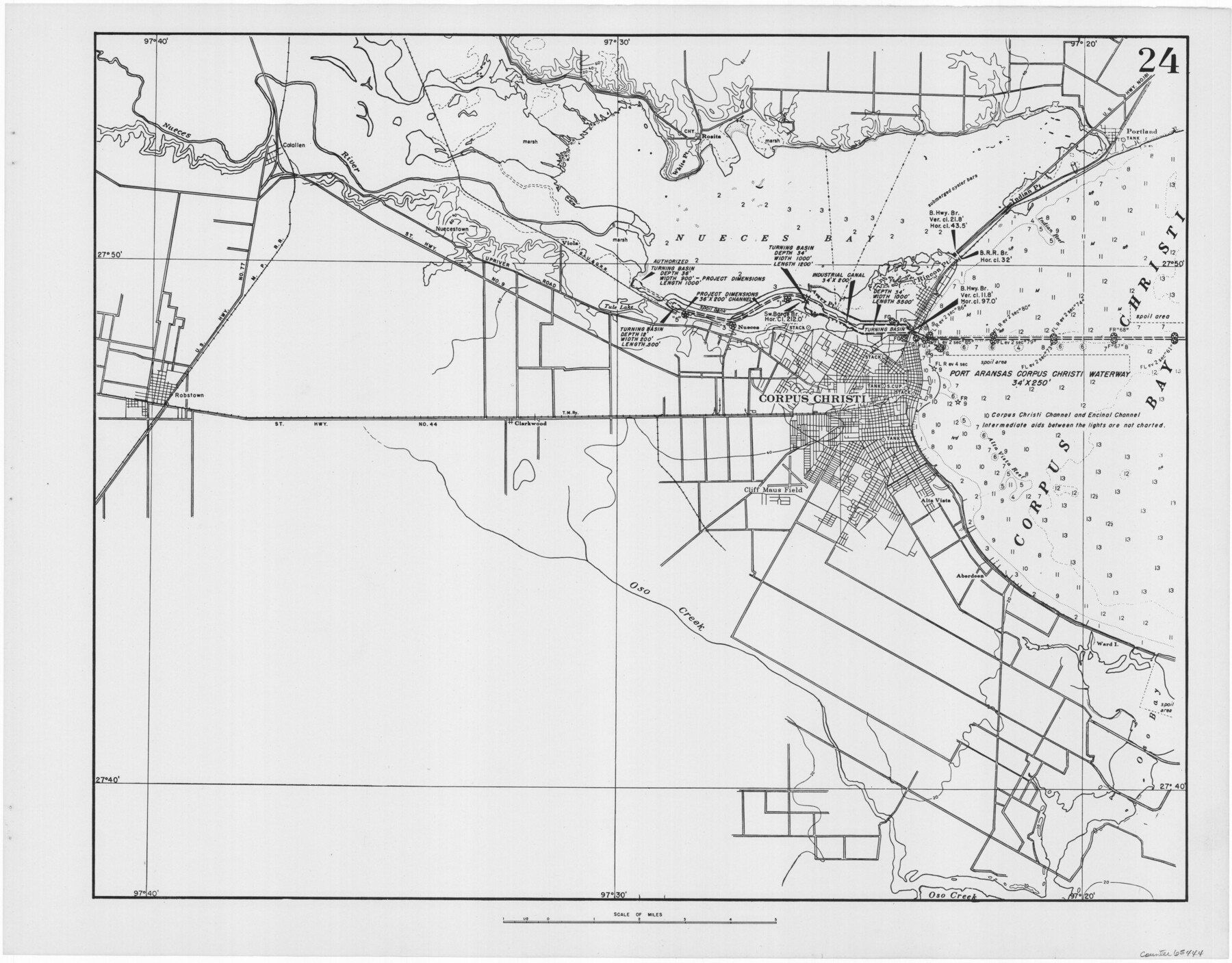
Navigation Maps of Gulf Intracoastal Waterway, Port Arthur to Brownsville, Texas
K-7-68
-
Map/Doc
65444
-
Collection
General Map Collection
-
Object Dates
1951 (Creation Date)
-
People and Organizations
Corps of Engineers (Publisher)
-
Counties
San Patricio Nueces
-
Subjects
Intracoastal Waterways
-
Height x Width
16.7 x 21.3 inches
42.4 x 54.1 cm
Part of: General Map Collection
Val Verde County Working Sketch 28

Print $20.00
- Digital $50.00
Val Verde County Working Sketch 28
1937
Size 45.9 x 38.6 inches
Map/Doc 72163
Erath County Sketch File 3

Print $4.00
- Digital $50.00
Erath County Sketch File 3
1853
Size 13.0 x 8.3 inches
Map/Doc 22255
Cameron County Rolled Sketch 25

Print $20.00
- Digital $50.00
Cameron County Rolled Sketch 25
1977
Size 24.8 x 36.6 inches
Map/Doc 5798
Pecos County Rolled Sketch 190

Print $20.00
- Digital $50.00
Pecos County Rolled Sketch 190
2005
Size 20.3 x 26.1 inches
Map/Doc 83284
Cottle County

Print $20.00
- Digital $50.00
Cottle County
1971
Size 43.4 x 36.0 inches
Map/Doc 95467
Donley County Working Sketch 2

Print $20.00
- Digital $50.00
Donley County Working Sketch 2
1916
Size 15.2 x 17.1 inches
Map/Doc 68735
Irion County Sketch File 16

Print $8.00
- Digital $50.00
Irion County Sketch File 16
1952
Size 11.1 x 8.7 inches
Map/Doc 27490
[Map of the River Sabine from its mouth on the Gulf of Mexico in the sea to Logan's Ferry in Latitude 31° 58' 24" North]
![94006, [Map of the River Sabine from its mouth on the Gulf of Mexico in the sea to Logan's Ferry in Latitude 31° 58' 24" North], General Map Collection](https://historictexasmaps.com/wmedia_w700/maps/94006.tif.jpg)
Print $20.00
- Digital $50.00
[Map of the River Sabine from its mouth on the Gulf of Mexico in the sea to Logan's Ferry in Latitude 31° 58' 24" North]
Size 37.7 x 31.6 inches
Map/Doc 94006
Zavala County Sketch File 25

Print $4.00
- Digital $50.00
Zavala County Sketch File 25
1886
Size 14.5 x 8.8 inches
Map/Doc 41388
Flight Mission No. DQN-1K, Frame 65, Calhoun County

Print $20.00
- Digital $50.00
Flight Mission No. DQN-1K, Frame 65, Calhoun County
1953
Size 18.5 x 22.2 inches
Map/Doc 84152
Presidio County Rolled Sketch 131A

Print $20.00
- Digital $50.00
Presidio County Rolled Sketch 131A
Size 17.7 x 11.9 inches
Map/Doc 10710
Stonewall County Sketch File 24

Print $6.00
- Digital $50.00
Stonewall County Sketch File 24
1951
Size 24.8 x 35.2 inches
Map/Doc 12369
You may also like
Brewster County Rolled Sketch 24B

Print $20.00
- Digital $50.00
Brewster County Rolled Sketch 24B
Size 17.2 x 22.4 inches
Map/Doc 5209
Limestone County, 1922

Print $40.00
- Digital $50.00
Limestone County, 1922
1922
Size 36.4 x 50.1 inches
Map/Doc 89704
Travis County Rolled Sketch 5

Print $20.00
- Digital $50.00
Travis County Rolled Sketch 5
1924
Size 24.1 x 27.9 inches
Map/Doc 8011
Kerr County Sketch File 22

Print $8.00
- Digital $50.00
Kerr County Sketch File 22
Size 11.3 x 8.7 inches
Map/Doc 28897
Culberson County Rolled Sketch 18

Print $6.00
- Digital $50.00
Culberson County Rolled Sketch 18
1911
Size 24.1 x 34.5 inches
Map/Doc 5650
Flight Mission No. DAG-24K, Frame 151, Matagorda County

Print $20.00
- Digital $50.00
Flight Mission No. DAG-24K, Frame 151, Matagorda County
1953
Size 18.5 x 22.1 inches
Map/Doc 86565
Topographical Map of the Rio Grande, Sheet No. 16

Print $20.00
- Digital $50.00
Topographical Map of the Rio Grande, Sheet No. 16
1912
Map/Doc 89540
Freestone County Working Sketch 17

Print $20.00
- Digital $50.00
Freestone County Working Sketch 17
1980
Size 44.8 x 31.0 inches
Map/Doc 69259
Culberson County Working Sketch 28

Print $40.00
- Digital $50.00
Culberson County Working Sketch 28
1952
Size 51.3 x 38.9 inches
Map/Doc 68481
Lee County Working Sketch 15

Print $20.00
- Digital $50.00
Lee County Working Sketch 15
1981
Size 18.4 x 14.0 inches
Map/Doc 70394
Colorado County Rolled Sketch 3

Print $20.00
- Digital $50.00
Colorado County Rolled Sketch 3
1943
Size 42.4 x 38.7 inches
Map/Doc 8641
Atascosa County Working Sketch 37

Print $20.00
- Digital $50.00
Atascosa County Working Sketch 37
2004
Size 23.2 x 24.1 inches
Map/Doc 89049