El Paso County Boundary File 6
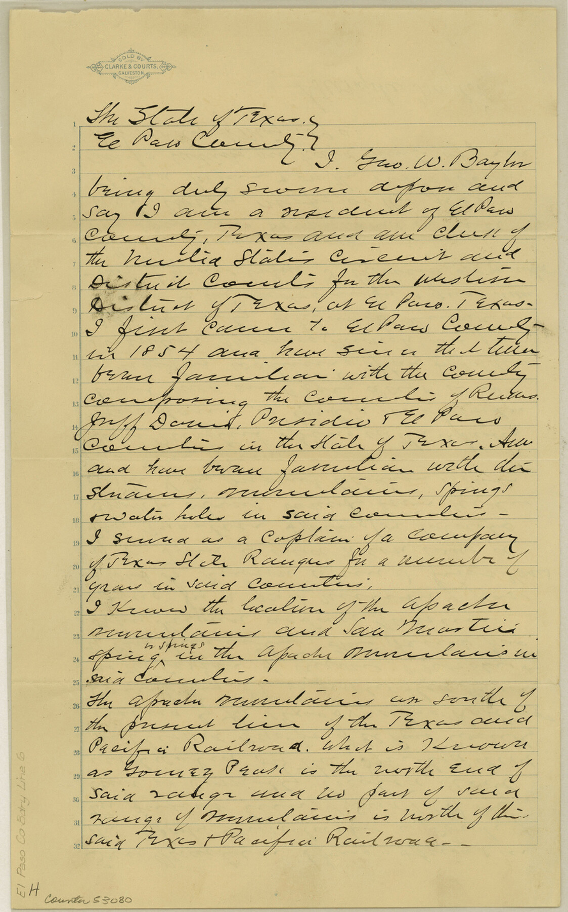
Affidavit of Geo. W. Baylor for position of San Martin Spr. living near Gomez Pk. & S. of RR.
-
Map/Doc
53080
-
Collection
General Map Collection
-
Counties
El Paso
-
Subjects
County Boundaries
-
Height x Width
14.0 x 8.8 inches
35.6 x 22.4 cm
Part of: General Map Collection
Map of Robertson County

Print $20.00
- Digital $50.00
Map of Robertson County
1888
Size 29.1 x 23.9 inches
Map/Doc 83004
Hill County Sketch File 20

Print $22.00
- Digital $50.00
Hill County Sketch File 20
1854
Size 8.3 x 7.7 inches
Map/Doc 26490
Andrews County Working Sketch 26

Print $20.00
- Digital $50.00
Andrews County Working Sketch 26
1983
Size 34.3 x 37.5 inches
Map/Doc 67072
Glasscock County Rolled Sketch 12

Print $20.00
- Digital $50.00
Glasscock County Rolled Sketch 12
1957
Size 19.6 x 16.1 inches
Map/Doc 6018
Ochiltree County Boundary File 10

Print $24.00
- Digital $50.00
Ochiltree County Boundary File 10
Size 11.2 x 8.7 inches
Map/Doc 57728
Hunt County Sketch File 36

Print $6.00
- Digital $50.00
Hunt County Sketch File 36
1879
Size 8.0 x 6.9 inches
Map/Doc 27150
Galveston County NRC Article 33.136 Sketch 22

Print $24.00
- Digital $50.00
Galveston County NRC Article 33.136 Sketch 22
2003
Size 24.2 x 36.0 inches
Map/Doc 78661
Palo Pinto County Working Sketch 16

Print $20.00
- Digital $50.00
Palo Pinto County Working Sketch 16
1974
Size 35.5 x 42.4 inches
Map/Doc 71399
Midland County

Print $20.00
- Digital $50.00
Midland County
1896
Size 23.0 x 21.1 inches
Map/Doc 3878
Burleson County Working Sketch 9

Print $20.00
- Digital $50.00
Burleson County Working Sketch 9
1980
Size 26.2 x 25.2 inches
Map/Doc 67728

Montgomery County Rolled Sketch 42

Print $20.00
- Digital $50.00
Montgomery County Rolled Sketch 42
1939
Size 13.9 x 20.2 inches
Map/Doc 6816
You may also like
Township 5 North Range 13 West, North Western District, Louisiana

Print $20.00
- Digital $50.00
Township 5 North Range 13 West, North Western District, Louisiana
1885
Size 19.8 x 24.7 inches
Map/Doc 65865
Geological Survey of Texas, First Annual Report, Plate II, Figures 6, 7, 8, 9

Print $20.00
- Digital $50.00
Geological Survey of Texas, First Annual Report, Plate II, Figures 6, 7, 8, 9
Size 17.1 x 18.1 inches
Map/Doc 75114
Pecos County Sketch File 92

Print $4.00
- Digital $50.00
Pecos County Sketch File 92
1954
Size 11.2 x 8.6 inches
Map/Doc 33988
Map of the Texas & Pacific Ry. Reserve West of the Pecos River

Print $20.00
- Digital $50.00
Map of the Texas & Pacific Ry. Reserve West of the Pecos River
1879
Size 41.1 x 29.8 inches
Map/Doc 65332
Edwards County Rolled Sketch 18

Print $20.00
- Digital $50.00
Edwards County Rolled Sketch 18
1947
Size 21.8 x 21.2 inches
Map/Doc 5807
Floyd County Sketch File 23

Print $8.00
- Digital $50.00
Floyd County Sketch File 23
1914
Size 11.6 x 9.0 inches
Map/Doc 22776
Falls County Sketch File 20

Print $12.00
- Digital $50.00
Falls County Sketch File 20
1869
Size 10.0 x 8.3 inches
Map/Doc 22388
Hydrographic Survey H-6395 of Outer Coast of Padre Island; Gulf of Mexico

Print $40.00
- Digital $50.00
Hydrographic Survey H-6395 of Outer Coast of Padre Island; Gulf of Mexico
1938
Size 55.1 x 33.3 inches
Map/Doc 2697
Spanish and Mexican Land Grants in Texas

Print $20.00
Spanish and Mexican Land Grants in Texas
2015
Size 34.0 x 44.0 inches
Map/Doc 93755
The Republic County of Fayette. December 29, 1845

Print $20.00
The Republic County of Fayette. December 29, 1845
2020
Size 14.7 x 21.7 inches
Map/Doc 96136
Menard County Boundary File 8

Print $4.00
- Digital $50.00
Menard County Boundary File 8
Size 11.1 x 8.7 inches
Map/Doc 57092
Plano General de la Ciudad de Mexico. Levantado Por el Teniente Coronel Don Diego Garcia Conde en el Año de 1793. Aumentado y corregido en lo mas notable Por el Teniente Coronel retirado, Don Rafael Maria Calvo En el de 1830

Print $20.00
- Digital $50.00
Plano General de la Ciudad de Mexico. Levantado Por el Teniente Coronel Don Diego Garcia Conde en el Año de 1793. Aumentado y corregido en lo mas notable Por el Teniente Coronel retirado, Don Rafael Maria Calvo En el de 1830
1793
Size 19.7 x 21.8 inches
Map/Doc 95354