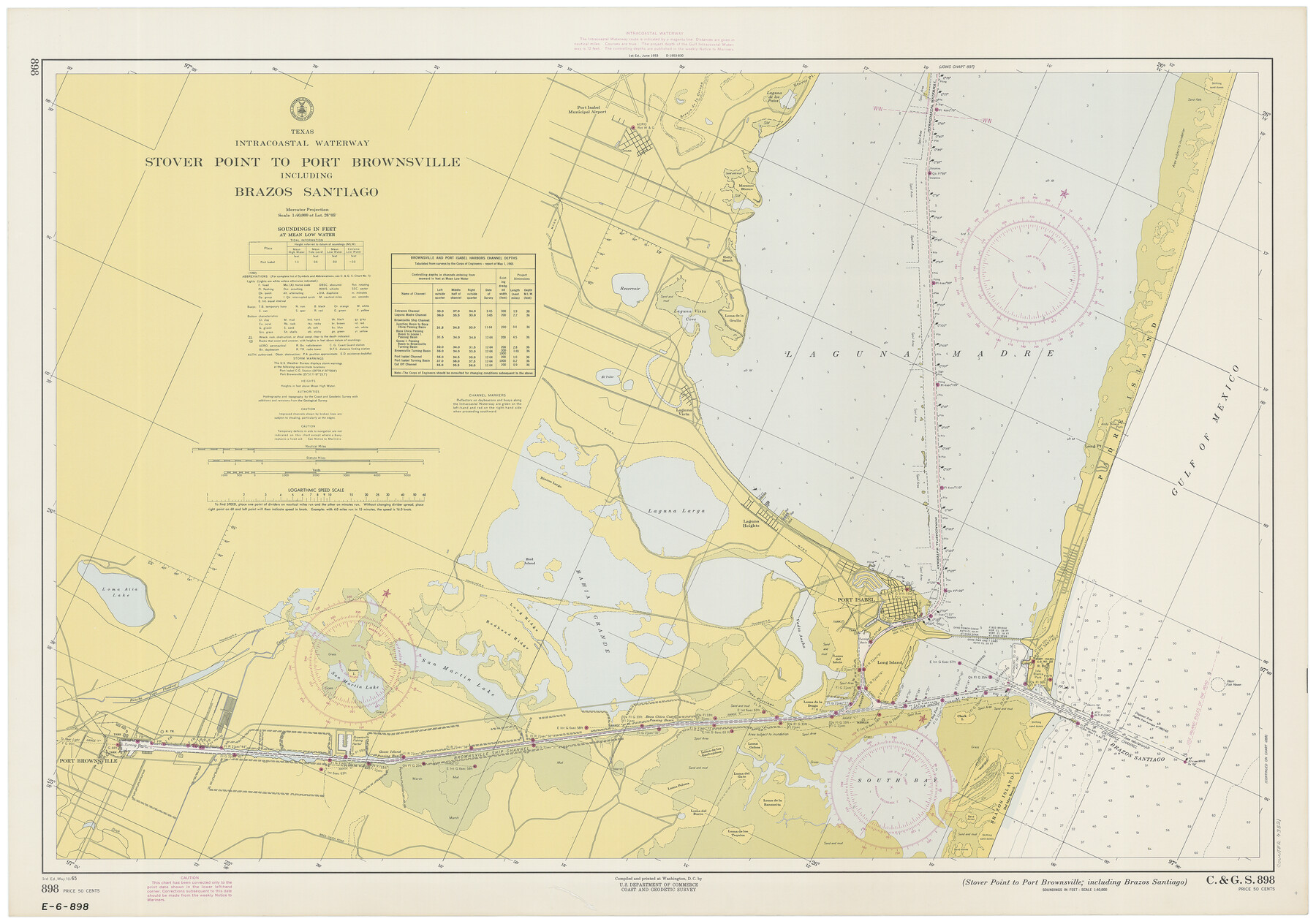
Texas Intracoastal Waterway - Stover Point to Port Brownsville including Brazos Santiago
K-6-898a
-
Map/Doc
73521
-
Collection
General Map Collection
-
Object Dates
5/10/1965 (Creation Date)
-
Counties
Cameron
-
Subjects
Nautical Charts
-
Height x Width
27.5 x 38.9 inches
69.9 x 98.8 cm
Part of: General Map Collection
Crane County Sketch File 24

Print $20.00
- Digital $50.00
Crane County Sketch File 24
Size 23.0 x 17.0 inches
Map/Doc 11212
Brewster County Rolled Sketch 86

Print $20.00
- Digital $50.00
Brewster County Rolled Sketch 86
1940
Size 16.1 x 26.4 inches
Map/Doc 5247
Flight Mission No. CRC-4R, Frame 186, Chambers County

Print $20.00
- Digital $50.00
Flight Mission No. CRC-4R, Frame 186, Chambers County
1956
Size 18.6 x 22.3 inches
Map/Doc 84937
Sterling County Sketch File 17

Print $8.00
- Digital $50.00
Sterling County Sketch File 17
1936
Size 11.2 x 8.8 inches
Map/Doc 37154
Presidio County Working Sketch 138

Print $20.00
- Digital $50.00
Presidio County Working Sketch 138
1990
Size 17.4 x 41.2 inches
Map/Doc 71816
Leon County Working Sketch 52a

Print $20.00
- Digital $50.00
Leon County Working Sketch 52a
1982
Size 35.1 x 42.8 inches
Map/Doc 70451
[Gulf Coast portion of] Map of the State of Texas
![72706, [Gulf Coast portion of] Map of the State of Texas, General Map Collection](https://historictexasmaps.com/wmedia_w700/maps/72706.tif.jpg)
Print $20.00
- Digital $50.00
[Gulf Coast portion of] Map of the State of Texas
1865
Size 27.2 x 18.2 inches
Map/Doc 72706

Sketch of Colorado Co. presented by Mr. Mason

Print $2.00
- Digital $50.00
Sketch of Colorado Co. presented by Mr. Mason
1845
Size 14.3 x 8.2 inches
Map/Doc 69736

Map of the Surveyed Part of Young District

Print $40.00
- Digital $50.00
Map of the Surveyed Part of Young District
1860
Size 56.3 x 32.6 inches
Map/Doc 87373
Map of Surveys Made for the T&PRR in Andrews & Martin Counties, Blocks 37, 38, 39, 40 & 41, Reserve West of the Colorado River

Print $20.00
- Digital $50.00
Map of Surveys Made for the T&PRR in Andrews & Martin Counties, Blocks 37, 38, 39, 40 & 41, Reserve West of the Colorado River
1876
Size 42.0 x 36.8 inches
Map/Doc 2229
You may also like
Donley County Sketch File 23

Print $4.00
- Digital $50.00
Donley County Sketch File 23
Size 8.4 x 14.5 inches
Map/Doc 21258
Topographic Map of Big Bend Area

Print $20.00
Topographic Map of Big Bend Area
1923
Size 35.5 x 40.7 inches
Map/Doc 79758
Red River County Working Sketch 76

Print $20.00
- Digital $50.00
Red River County Working Sketch 76
1980
Size 17.7 x 33.9 inches
Map/Doc 72059
Fisher County Working Sketch 18

Print $20.00
- Digital $50.00
Fisher County Working Sketch 18
1941
Size 24.7 x 16.6 inches
Map/Doc 69152
Crockett County Sketch File 93

Print $8.00
- Digital $50.00
Crockett County Sketch File 93
1887
Size 12.7 x 8.2 inches
Map/Doc 19946
Flight Mission No. CRK-8P, Frame 106, Refugio County

Print $20.00
- Digital $50.00
Flight Mission No. CRK-8P, Frame 106, Refugio County
1956
Size 18.3 x 22.1 inches
Map/Doc 86967
Terrell County Working Sketch 84c

Print $20.00
- Digital $50.00
Terrell County Working Sketch 84c
1992
Size 18.2 x 31.3 inches
Map/Doc 69607
Engineer map showing engineer information at 23 O'Clock 23 Oct. 1918 drawn under direction of Col. W.A. Mitchell - Verso

Print $20.00
Engineer map showing engineer information at 23 O'Clock 23 Oct. 1918 drawn under direction of Col. W.A. Mitchell - Verso
1918
Size 19.7 x 12.6 inches
Map/Doc 94128
Jasper County Working Sketch 9

Print $20.00
- Digital $50.00
Jasper County Working Sketch 9
1917
Size 21.0 x 14.3 inches
Map/Doc 66471
Erath County Working Sketch 38

Print $20.00
- Digital $50.00
Erath County Working Sketch 38
1974
Size 22.1 x 31.7 inches
Map/Doc 69119
Wise County Sketch File 14

Print $24.00
- Digital $50.00
Wise County Sketch File 14
1855
Size 12.8 x 8.2 inches
Map/Doc 40548
Lynn County Sketch File 4

Print $12.00
- Digital $50.00
Lynn County Sketch File 4
1902
Size 12.8 x 8.2 inches
Map/Doc 30458