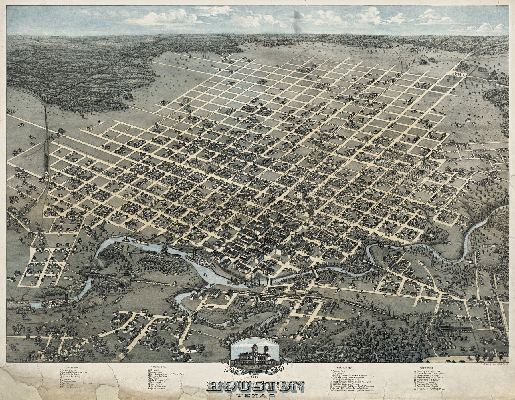
Bird's Eye View of the City of Houston, Texas
-
Map/Doc
89093
-
Collection
Non-GLO Digital Images
-
Object Dates
1873 (Creation Date)
-
People and Organizations
Augustus Koch (Draftsman)
-
Counties
Harris
-
Subjects
Bird's Eye View City Pictorial
-
Height x Width
24.0 x 30.9 inches
61.0 x 78.5 cm
-
Comments
Bird's Eye View map. Public Domain image obtained from Wikimedia Commons.
Part of: Non-GLO Digital Images
[Movements & Objectives of the 143rd & 144th Infantry on October 12-13, 1918] - Verso
![94136, [Movements & Objectives of the 143rd & 144th Infantry on October 12-13, 1918] - Verso, Non-GLO Digital Images](https://historictexasmaps.com/wmedia_w700/maps/94136-1.tif.jpg)
Print $20.00
[Movements & Objectives of the 143rd & 144th Infantry on October 12-13, 1918] - Verso
1918
Size 42.4 x 30.0 inches
Map/Doc 94136
The Scarborough Company's New Railroad, Post Office & County Map of Texas, Oklahoma and Indian Territory Compiled from the Latest Government Surveys and Original Sources

Print $20.00
The Scarborough Company's New Railroad, Post Office & County Map of Texas, Oklahoma and Indian Territory Compiled from the Latest Government Surveys and Original Sources
1904
Size 43.1 x 47.8 inches
Map/Doc 93967
Map of Texas with Parts of the Adjoining States

Print $20.00
Map of Texas with Parts of the Adjoining States
1836
Size 29.8 x 24.1 inches
Map/Doc 93963
Guadalupe-Blanco River Authority Master Plan

Print $20.00
Guadalupe-Blanco River Authority Master Plan
Size 23.1 x 29.8 inches
Map/Doc 97506
Engineer map showing engineer information at 23 O'Clock 23 Oct. 1918 drawn under direction of Col. W.A. Mitchell

Print $20.00
Engineer map showing engineer information at 23 O'Clock 23 Oct. 1918 drawn under direction of Col. W.A. Mitchell
1918
Size 19.6 x 12.5 inches
Map/Doc 94127
Seymour, Baylor County, Texas

Print $20.00
Seymour, Baylor County, Texas
1890
Size 15.4 x 24.2 inches
Map/Doc 89207
Carta Particular de la Parte sur del Seno Mexicano que comprehende las Cóstas de Yucatan y Sonda de Campeche, las de Tabasco, Veracruz y Tamaulipas

Carta Particular de la Parte sur del Seno Mexicano que comprehende las Cóstas de Yucatan y Sonda de Campeche, las de Tabasco, Veracruz y Tamaulipas
1825
Size 26.6 x 38.5 inches
Map/Doc 94567

Rain Chart of the United States showing by isohyetal lines the distribution of the mean annual precipitation in rain and melted snow

Print $20.00
Rain Chart of the United States showing by isohyetal lines the distribution of the mean annual precipitation in rain and melted snow
1878
Size 20.8 x 29.4 inches
Map/Doc 95190
El Nuevo México y Tierras Adyacentes Levantado para la Demarcación de los Límites de los Dominios Españoles y de los Estados Unidos

El Nuevo México y Tierras Adyacentes Levantado para la Demarcación de los Límites de los Dominios Españoles y de los Estados Unidos
1811
Size 9.4 x 12.6 inches
Map/Doc 94445
Carta Esférica del Seno Mexicano y Canales Viexo y de Bama

Carta Esférica del Seno Mexicano y Canales Viexo y de Bama
1797
Size 26.7 x 47.1 inches
Map/Doc 94569
[Movements & Objectives of the 143rd & 144th Infantry & 133rd Machine Gun Battalion on October 8-9, 1918, Appendix E, No. 4]
![94133, [Movements & Objectives of the 143rd & 144th Infantry & 133rd Machine Gun Battalion on October 8-9, 1918, Appendix E, No. 4], Non-GLO Digital Images](https://historictexasmaps.com/wmedia_w700/maps/94133-1.tif.jpg)
Print $20.00
[Movements & Objectives of the 143rd & 144th Infantry & 133rd Machine Gun Battalion on October 8-9, 1918, Appendix E, No. 4]
1918
Size 21.5 x 20.2 inches
Map/Doc 94133
You may also like
Flight Mission No. BRE-1P, Frame 125, Nueces County

Print $20.00
- Digital $50.00
Flight Mission No. BRE-1P, Frame 125, Nueces County
1956
Size 18.6 x 22.7 inches
Map/Doc 86691
Haskell County Rolled Sketch 15

Print $20.00
- Digital $50.00
Haskell County Rolled Sketch 15
1991
Size 12.7 x 18.4 inches
Map/Doc 6173
Flight Mission No. DCL-6C, Frame 12, Kenedy County

Print $20.00
- Digital $50.00
Flight Mission No. DCL-6C, Frame 12, Kenedy County
1943
Size 18.7 x 22.4 inches
Map/Doc 85869
Matagorda County Rolled Sketch 31

Print $187.00
- Digital $50.00
Matagorda County Rolled Sketch 31
Size 10.6 x 15.5 inches
Map/Doc 46654
Flight Mission No. DCL-6C, Frame 54, Kenedy County

Print $20.00
- Digital $50.00
Flight Mission No. DCL-6C, Frame 54, Kenedy County
1943
Size 18.6 x 22.4 inches
Map/Doc 85896
Maps & Lists Showing Prison Lands (Oil & Gas) Leased as of June 1955

Digital $50.00
Maps & Lists Showing Prison Lands (Oil & Gas) Leased as of June 1955
1934
Size 29.6 x 38.1 inches
Map/Doc 62880
Flight Mission No. DQN-2K, Frame 8, Calhoun County

Print $20.00
- Digital $50.00
Flight Mission No. DQN-2K, Frame 8, Calhoun County
1953
Size 15.8 x 15.6 inches
Map/Doc 84225

Hays County Boundary File

Print $120.00
- Digital $50.00
Hays County Boundary File
1947
Size 33.6 x 20.8 inches
Map/Doc 65496
Maps of Gulf Intracoastal Waterway, Texas - Sabine River to the Rio Grande and connecting waterways including ship channels

Print $20.00
- Digital $50.00
Maps of Gulf Intracoastal Waterway, Texas - Sabine River to the Rio Grande and connecting waterways including ship channels
1966
Size 14.5 x 22.3 inches
Map/Doc 61948
Stephens County Rolled Sketch 2

Print $20.00
- Digital $50.00
Stephens County Rolled Sketch 2
1919
Size 24.8 x 30.3 inches
Map/Doc 7839
Flight Mission No. CRC-3R, Frame 15, Chambers County

Print $20.00
- Digital $50.00
Flight Mission No. CRC-3R, Frame 15, Chambers County
1956
Size 18.5 x 22.2 inches
Map/Doc 84789