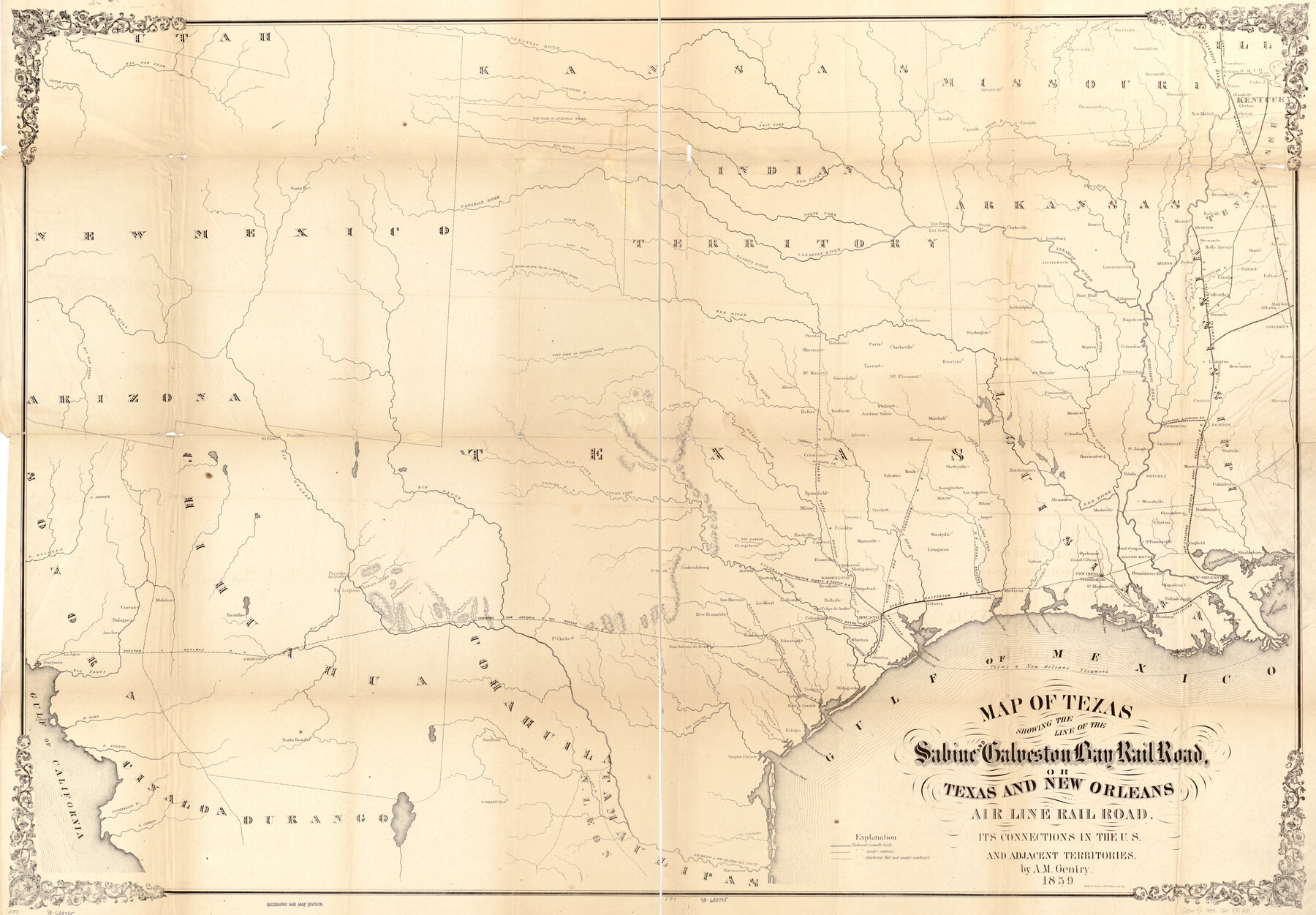
Map of Texas showing the Sabine and Galveston Bay Rail Road, or Texas and New Orleans Air Line Rail Line, its connections in the U.S. and adjacent territories.
- 
                          Map/Doc
93610
 - 
                            Collection
Library of Congress
 - 
                            Object Dates
1859 (Creation Date)
 - 
                            People and Organizations
A.M. Gentry (Publisher)
 - 
                            Subjects
Railroads State of Texas
 - 
                            Height x Width
28.7 x 41.3 inches
72.9 x 104.9 cm
 - 
                            Comments
For more information see here. Prints available from the GLO courtesy of Library of Congress, Geography and Map Division.
 
Part of: Library of Congress
            Map of Stephens County, Texas


                                            Print $20.00                    
                                    
                Map of Stephens County, Texas
1870
Size 24.0 x 19.3 inches
                                Map/Doc 93588
            
            Perspective Map of the City of Laredo, Texas, the Gateway to and from Mexico


                                            Print $20.00                    
                                    
                Perspective Map of the City of Laredo, Texas, the Gateway to and from Mexico
1892
Size 24.0 x 36.7 inches
                                Map/Doc 93478
            
            Map exhibiting the fixed location of the main trunk of the New-Orleans, Opelousas & Great Western Railroad of Louisiana…


                                            Print $20.00                    
                                    
                Map exhibiting the fixed location of the main trunk of the New-Orleans, Opelousas & Great Western Railroad of Louisiana…
1859
Size 25.2 x 37.0 inches
                                Map/Doc 93582
            
            Map of Callahan Co[unty]


                                            Print $20.00                    
                                    
                Map of Callahan Co[unty]
1879
Size 24.7 x 18.5 inches
                                Map/Doc 88916
            
            Map of Eastland Co[unty]


                                            Print $20.00                    
                                    
                Map of Eastland Co[unty]
1896
Size 45.0 x 42.8 inches
                                Map/Doc 88929
            
            Map of Comanche County


                                            Print $20.00                    
                                    
                Map of Comanche County
1876
Size 28.0 x 24.1 inches
                                Map/Doc 88919
            
            Campaign map of Texas, Louisiana and Arkansas, showing all the battle fields and also the marches of Walker's Division. [1861-65]


                                            Print $20.00                    
                                    
                Campaign map of Texas, Louisiana and Arkansas, showing all the battle fields and also the marches of Walker's Division. [1861-65]
1871
Size 27.6 x 37.0 inches
                                Map/Doc 93567
            
            Map of Hamilton County


                                            Print $20.00                    
                                    
                Map of Hamilton County
1876
Size 19.0 x 22.2 inches
                                Map/Doc 88945
            You may also like
            Isogonic Chart for 1950, United States.  Including Isoporic Lines


                                            Print $20.00                    
                                             -                         Digital $50.00                                    
                Isogonic Chart for 1950, United States. Including Isoporic Lines
1950
Size 32.2 x 47.2 inches
                                Map/Doc 75921
            
            Hartley County Working Sketch 4


                                            Print $20.00                    
                                             -                         Digital $50.00                                    
                Hartley County Working Sketch 4
1934
Size 23.9 x 30.6 inches
                                Map/Doc 66054
            
            The Republic County of Austin. Proposed, Fall 1837-May 23, 1838


                                            Print $20.00                    
                                    
                The Republic County of Austin. Proposed, Fall 1837-May 23, 1838
2020
Size 14.8 x 21.7 inches
                                Map/Doc 96081
            
            Roberts County Working Sketch 25


                                            Print $20.00                    
                                             -                         Digital $50.00                                    
                Roberts County Working Sketch 25
1982
Size 23.0 x 20.4 inches
                                Map/Doc 63551
            
            [Blocks in East Floyd County and West Motley County showing Blocks D2, D3, GM, GP and T]


                                            Print $20.00                    
                                             -                         Digital $50.00                                    
                [Blocks in East Floyd County and West Motley County showing Blocks D2, D3, GM, GP and T]
Size 22.2 x 10.9 inches
                                Map/Doc 92113
            
            From Citizens of Austin and Harris Counties Living in What Was to Become Fort Bend County for the Creation of a New County (Unnamed), Undated


                                            Print $20.00                    
                                    
                From Citizens of Austin and Harris Counties Living in What Was to Become Fort Bend County for the Creation of a New County (Unnamed), Undated
2020
Size 22.6 x 21.7 inches
                                Map/Doc 96399
            
            Map of the country in the vicinity of San Antonio de Bexar reduced in part from the county map of Bexar with additions by J. Edmd. Blake, 1st Lieut Topl. Engs.


                                            Print $20.00                    
                                             -                         Digital $50.00                                    
                Map of the country in the vicinity of San Antonio de Bexar reduced in part from the county map of Bexar with additions by J. Edmd. Blake, 1st Lieut Topl. Engs.
1845
Size 18.3 x 26.1 inches
                                Map/Doc 72721
            
            Webb County Sketch File 50-1


                                            Print $8.00                    
                                             -                         Digital $50.00                                    
                Webb County Sketch File 50-1
1943
Size 14.5 x 8.9 inches
                                Map/Doc 39833
            
            [Mrs. May Vinson Survey]


                                            Print $20.00                    
                                             -                         Digital $50.00                                    
                [Mrs. May Vinson Survey]
Size 26.7 x 14.8 inches
                                Map/Doc 91877
            
            Flight Mission No. CGI-3N, Frame 187, Cameron County


                                            Print $20.00                    
                                             -                         Digital $50.00                                    
                Flight Mission No. CGI-3N, Frame 187, Cameron County
1954
Size 18.5 x 22.2 inches
                                Map/Doc 84651
            
            Plat Showing the Construction of Texas & Pacific Ry. Co. Blocks 3 & 4 As Located by G. A. Lider


                                            Print $40.00                    
                                             -                         Digital $50.00                                    
                Plat Showing the Construction of Texas & Pacific Ry. Co. Blocks 3 & 4 As Located by G. A. Lider
1913
Size 51.4 x 36.3 inches
                                Map/Doc 89931