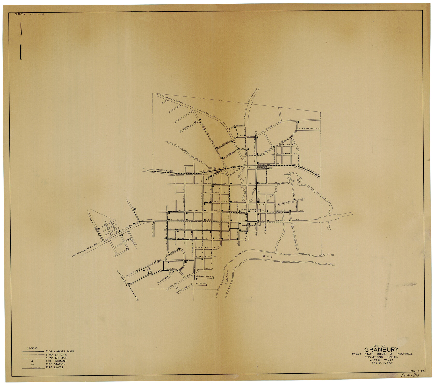
Map of Granbury
A-6-28
-
Map/Doc
3041
-
Collection
General Map Collection
-
Object Dates
1960 (Creation Date)
-
People and Organizations
Texas Fire Insurance Department (Publisher)
-
Counties
Hood
-
Subjects
City
-
Height x Width
23.5 x 26.7 inches
59.7 x 67.8 cm
-
Medium
blueprint/diazo
-
Scale
1" = 600 ft.
-
Comments
Texas Board of Insurance, Engineering Division.
Street map showing locations of water mains, fire hydrants and fire station. -
Features
Granbury
FM Highway 4 to Lipan
FM Highway 51 to Weatherford
Lambert Branch [of Brazos River]
Santa Fe Railroad
Stephenville Highway US 377
Brazos River
Part of: General Map Collection
Val Verde County Sketch File XXX7

Print $6.00
- Digital $50.00
Val Verde County Sketch File XXX7
Size 11.0 x 15.4 inches
Map/Doc 39104
Rusk County Rolled Sketch 6

Print $20.00
- Digital $50.00
Rusk County Rolled Sketch 6
1949
Size 33.7 x 26.6 inches
Map/Doc 7543
South Part of El Paso Co.

Print $20.00
- Digital $50.00
South Part of El Paso Co.
1977
Size 36.5 x 47.8 inches
Map/Doc 95491
Bandera County Boundary File 2

Print $4.00
- Digital $50.00
Bandera County Boundary File 2
Size 9.1 x 7.5 inches
Map/Doc 50264
McMullen County Sketch File 31

Print $20.00
- Digital $50.00
McMullen County Sketch File 31
Size 44.7 x 15.6 inches
Map/Doc 10541
Map of Presidio County, Texas

Print $40.00
- Digital $50.00
Map of Presidio County, Texas
Size 42.6 x 86.0 inches
Map/Doc 76071
Travis County Working Sketch 39

Print $20.00
- Digital $50.00
Travis County Working Sketch 39
1974
Size 33.1 x 31.7 inches
Map/Doc 69423
Concho County Sketch File 32

Print $20.00
- Digital $50.00
Concho County Sketch File 32
Size 29.6 x 26.7 inches
Map/Doc 11157
Flight Mission No. BQY-15M, Frame 22, Harris County

Print $20.00
- Digital $50.00
Flight Mission No. BQY-15M, Frame 22, Harris County
1953
Size 18.6 x 22.3 inches
Map/Doc 85320
Cass County Rolled Sketch WDC

Print $20.00
- Digital $50.00
Cass County Rolled Sketch WDC
Size 20.8 x 32.9 inches
Map/Doc 5416
Mitchell County Rolled Sketch 2A

Print $20.00
- Digital $50.00
Mitchell County Rolled Sketch 2A
Size 24.2 x 18.6 inches
Map/Doc 7954
Webb County Working Sketch 81

Print $40.00
- Digital $50.00
Webb County Working Sketch 81
1979
Size 69.0 x 43.6 inches
Map/Doc 72448
You may also like
El Paso County Working Sketch 23

Print $20.00
- Digital $50.00
El Paso County Working Sketch 23
1961
Size 22.3 x 28.8 inches
Map/Doc 69045
[Bastrop District]
![83006, [Bastrop District], General Map Collection](https://historictexasmaps.com/wmedia_w700/maps/83006-1.tif.jpg)
Print $40.00
- Digital $50.00
[Bastrop District]
1895
Size 71.8 x 52.3 inches
Map/Doc 83006
Flight Mission No. BRA-7M, Frame 7, Jefferson County

Print $20.00
- Digital $50.00
Flight Mission No. BRA-7M, Frame 7, Jefferson County
1953
Size 18.7 x 22.5 inches
Map/Doc 85458
Flight Mission No. DAG-24K, Frame 160, Matagorda County

Print $20.00
- Digital $50.00
Flight Mission No. DAG-24K, Frame 160, Matagorda County
1953
Size 18.6 x 22.5 inches
Map/Doc 86574
Liberty County Sketch File 8

Print $2.00
- Digital $50.00
Liberty County Sketch File 8
Size 8.3 x 10.1 inches
Map/Doc 29899
Levee Improvement Districts Widths of Floodways - Sulphur River and Cuthand Creek

Print $20.00
- Digital $50.00
Levee Improvement Districts Widths of Floodways - Sulphur River and Cuthand Creek
1924
Size 15.4 x 38.6 inches
Map/Doc 65155
Flight Mission No. CRC-3R, Frame 210, Chambers County

Print $20.00
- Digital $50.00
Flight Mission No. CRC-3R, Frame 210, Chambers County
1956
Size 18.6 x 22.3 inches
Map/Doc 84865
Hockley County

Print $20.00
- Digital $50.00
Hockley County
1914
Size 22.3 x 25.9 inches
Map/Doc 92244
Shackelford County Boundary File 7

Print $74.00
- Digital $50.00
Shackelford County Boundary File 7
Size 11.6 x 8.9 inches
Map/Doc 58671
Carte Reduite du Globe Terrestre

Print $20.00
- Digital $50.00
Carte Reduite du Globe Terrestre
1782
Size 13.5 x 17.1 inches
Map/Doc 97117
Map of Archer County

Print $20.00
- Digital $50.00
Map of Archer County
1886
Size 24.4 x 20.5 inches
Map/Doc 3240
Childress County Sketch File 18

Print $8.00
- Digital $50.00
Childress County Sketch File 18
1909
Size 14.3 x 9.0 inches
Map/Doc 18290