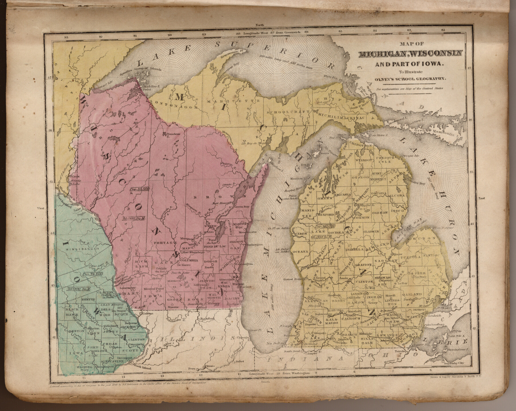
Map of Michigan, Wisconsin and part of Iowa to illustrate Olney's school geography
-
Map/Doc
93542
-
Collection
General Map Collection
-
Object Dates
1844 (Creation Date)
2013/7/12 (File Date)
-
People and Organizations
Pratt, Woodford and Co. (Publisher)
Sherman and Smith (Printer)
Galen Greaser (Donor)
J. Olney (Author)
Sherman and Smith (Draftsman)
-
Subjects
Atlas
-
Height x Width
9.5 x 12.1 inches
24.1 x 30.7 cm
-
Comments
Donated by Galen Greaser in 2009. Map is part of volume: "Olney's School Atlas". See 93534 for a PDF of this complete atlas.
Related maps
Olney's School Atlas

Print $326.00
- Digital $50.00
Olney's School Atlas
1844
Size 12.3 x 10.0 inches
Map/Doc 93534
Part of: General Map Collection
Val Verde County Working Sketch 22

Print $20.00
- Digital $50.00
Val Verde County Working Sketch 22
1931
Size 27.6 x 33.0 inches
Map/Doc 72157
Hunt County Working Sketch 8

Print $20.00
- Digital $50.00
Hunt County Working Sketch 8
1958
Size 24.5 x 24.4 inches
Map/Doc 66355
Map of Bell County

Print $40.00
- Digital $50.00
Map of Bell County
1896
Size 49.0 x 53.5 inches
Map/Doc 4768
Rusk County Rolled Sketch 4

Print $20.00
- Digital $50.00
Rusk County Rolled Sketch 4
1895
Size 47.8 x 33.9 inches
Map/Doc 9874
La Salle County Sketch File 53

Print $8.00
- Digital $50.00
La Salle County Sketch File 53
1992
Size 11.2 x 8.8 inches
Map/Doc 29624
United States - Gulf Coast - From Latitude 26° 33' to the Rio Grande Texas

Print $20.00
- Digital $50.00
United States - Gulf Coast - From Latitude 26° 33' to the Rio Grande Texas
1916
Size 27.8 x 18.3 inches
Map/Doc 72839
Map of the Passo Cavallo on the entrance into Matagorda Bay from the Gulf of Mexico

Print $20.00
- Digital $50.00
Map of the Passo Cavallo on the entrance into Matagorda Bay from the Gulf of Mexico
1853
Size 17.8 x 27.3 inches
Map/Doc 73012
Right of Way & Track Map, St. Louis, Brownsville & Mexico Ry. operated by St. Louis, Brownsville & Mexico Ry. Co.

Print $40.00
- Digital $50.00
Right of Way & Track Map, St. Louis, Brownsville & Mexico Ry. operated by St. Louis, Brownsville & Mexico Ry. Co.
1919
Size 25.4 x 56.9 inches
Map/Doc 64614
Duval County Sketch File 74

Print $42.00
- Digital $50.00
Duval County Sketch File 74
Size 10.1 x 8.8 inches
Map/Doc 21465
[F. W. & D. C. Ry. Co. Alignment and Right of Way Map, Clay County]
![64736, [F. W. & D. C. Ry. Co. Alignment and Right of Way Map, Clay County], General Map Collection](https://historictexasmaps.com/wmedia_w700/maps/64736-GC.tif.jpg)
Print $20.00
- Digital $50.00
[F. W. & D. C. Ry. Co. Alignment and Right of Way Map, Clay County]
1927
Size 18.6 x 11.7 inches
Map/Doc 64736
Flight Mission No. BRA-16M, Frame 117, Jefferson County

Print $20.00
- Digital $50.00
Flight Mission No. BRA-16M, Frame 117, Jefferson County
1953
Size 18.7 x 22.1 inches
Map/Doc 85727
Flight Mission No. DQN-5K, Frame 39, Calhoun County

Print $20.00
- Digital $50.00
Flight Mission No. DQN-5K, Frame 39, Calhoun County
1953
Size 18.5 x 22.1 inches
Map/Doc 84387
You may also like

Montgomery County Rolled Sketch 22

Print $40.00
- Digital $50.00
Montgomery County Rolled Sketch 22
1934
Size 38.0 x 61.7 inches
Map/Doc 9532
Pecos County Sketch File 39

Print $20.00
- Digital $50.00
Pecos County Sketch File 39
1898
Size 17.5 x 16.5 inches
Map/Doc 12177
Sutton County Sketch File 48

Print $4.00
- Digital $50.00
Sutton County Sketch File 48
1939
Size 11.3 x 8.7 inches
Map/Doc 37521
Kendall County

Print $20.00
- Digital $50.00
Kendall County
1946
Size 41.1 x 35.3 inches
Map/Doc 77336
Brewster County Working Sketch 90

Print $40.00
- Digital $50.00
Brewster County Working Sketch 90
1975
Size 61.0 x 43.3 inches
Map/Doc 67690
Medina County Sketch File 12

Print $6.00
- Digital $50.00
Medina County Sketch File 12
1907
Size 7.2 x 8.8 inches
Map/Doc 31468
Map of Main Line Houston & Tex. Centr. Railway from Dallas to Red River City

Print $40.00
- Digital $50.00
Map of Main Line Houston & Tex. Centr. Railway from Dallas to Red River City
Size 37.1 x 84.9 inches
Map/Doc 64089
Haskell County Working Sketch Graphic Index

Print $20.00
- Digital $50.00
Haskell County Working Sketch Graphic Index
1933
Size 43.3 x 37.7 inches
Map/Doc 76572
Live Oak County Boundary File 60

Print $12.00
- Digital $50.00
Live Oak County Boundary File 60
Size 8.8 x 7.6 inches
Map/Doc 56401
Flight Mission No. DQN-2K, Frame 77, Calhoun County

Print $20.00
- Digital $50.00
Flight Mission No. DQN-2K, Frame 77, Calhoun County
1953
Size 16.1 x 15.9 inches
Map/Doc 84269
Flight Mission No. DCL-6C, Frame 65, Kenedy County

Print $20.00
- Digital $50.00
Flight Mission No. DCL-6C, Frame 65, Kenedy County
1943
Size 18.5 x 22.3 inches
Map/Doc 85907