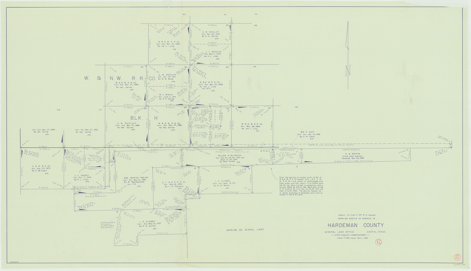
Hardeman County Working Sketch 12
-
Map/Doc
63393
-
Collection
General Map Collection
-
Object Dates
11/1/1963 (Creation Date)
-
People and Organizations
Roy Buckholts (Draftsman)
-
Counties
Hardeman
-
Subjects
Surveying Working Sketch
-
Height x Width
31.2 x 54.3 inches
79.3 x 137.9 cm
-
Scale
1" = 400 varas
Part of: General Map Collection
Gray County Working Sketch 1

Print $20.00
- Digital $50.00
Gray County Working Sketch 1
1957
Size 37.3 x 17.4 inches
Map/Doc 62196
Live Oak County Sketch File 19

Print $22.00
- Digital $50.00
Live Oak County Sketch File 19
1930
Size 11.2 x 8.6 inches
Map/Doc 30289
Flight Mission No. CRC-3R, Frame 18, Chambers County

Print $20.00
- Digital $50.00
Flight Mission No. CRC-3R, Frame 18, Chambers County
1956
Size 18.7 x 22.4 inches
Map/Doc 84792
Runnels County Working Sketch 20

Print $20.00
- Digital $50.00
Runnels County Working Sketch 20
1950
Size 23.1 x 30.9 inches
Map/Doc 63616
Flight Mission No. CUG-3P, Frame 143, Kleberg County

Print $20.00
- Digital $50.00
Flight Mission No. CUG-3P, Frame 143, Kleberg County
1956
Size 19.0 x 22.5 inches
Map/Doc 86278
Hood County Sketch File 11

Print $20.00
- Digital $50.00
Hood County Sketch File 11
Size 17.5 x 16.2 inches
Map/Doc 11779
Reagan County Rolled Sketch 21

Print $20.00
- Digital $50.00
Reagan County Rolled Sketch 21
1950
Size 32.5 x 42.2 inches
Map/Doc 9815
Presidio County Rolled Sketch 6

Print $40.00
- Digital $50.00
Presidio County Rolled Sketch 6
1949
Size 56.8 x 32.2 inches
Map/Doc 9761
Grayson County Working Sketch 14

Print $20.00
- Digital $50.00
Grayson County Working Sketch 14
1952
Size 23.9 x 23.3 inches
Map/Doc 63253
Flight Mission No. DIX-6P, Frame 181, Aransas County

Print $20.00
- Digital $50.00
Flight Mission No. DIX-6P, Frame 181, Aransas County
1956
Size 18.9 x 22.6 inches
Map/Doc 83843
Map of the European Settlements in Mexico or New Spain and the West Indies

Print $20.00
- Digital $50.00
Map of the European Settlements in Mexico or New Spain and the West Indies
1783
Size 14.1 x 21.1 inches
Map/Doc 93643
You may also like
Wilson County Working Sketch 4

Print $20.00
- Digital $50.00
Wilson County Working Sketch 4
1953
Size 30.8 x 28.5 inches
Map/Doc 72584
Upton County Rolled Sketch 2

Print $20.00
- Digital $50.00
Upton County Rolled Sketch 2
1884
Size 26.2 x 36.1 inches
Map/Doc 8065
Wylie Briscoe Farm

Print $2.00
- Digital $50.00
Wylie Briscoe Farm
Size 9.2 x 15.2 inches
Map/Doc 92273
[Sketch for Mineral Application 24072, San Jacinto River]
![65600, [Sketch for Mineral Application 24072, San Jacinto River], General Map Collection](https://historictexasmaps.com/wmedia_w700/maps/65600.tif.jpg)
Print $20.00
- Digital $50.00
[Sketch for Mineral Application 24072, San Jacinto River]
1929
Size 25.0 x 18.4 inches
Map/Doc 65600
Shelby County Working Sketch 20

Print $20.00
- Digital $50.00
Shelby County Working Sketch 20
1970
Size 28.0 x 22.8 inches
Map/Doc 63873
Controlled Mosaic by Jack Amman Photogrammetric Engineers, Inc - Sheet 37

Print $20.00
- Digital $50.00
Controlled Mosaic by Jack Amman Photogrammetric Engineers, Inc - Sheet 37
1954
Size 20.0 x 24.0 inches
Map/Doc 83491
Flight Mission No. DIX-10P, Frame 145, Aransas County

Print $20.00
- Digital $50.00
Flight Mission No. DIX-10P, Frame 145, Aransas County
1956
Size 18.7 x 22.3 inches
Map/Doc 83947
K&E Compensating Polar Planimeter

K&E Compensating Polar Planimeter
1972
Size 2.1 x 11.6 inches
Map/Doc 97302
Part of the boundary between the United States and Texas; from Sabine River northward to the 36th mile mound

Print $2.00
- Digital $50.00
Part of the boundary between the United States and Texas; from Sabine River northward to the 36th mile mound
1842
Size 12.5 x 7.6 inches
Map/Doc 93769
General Highway Map, Leon County, Texas

Print $20.00
General Highway Map, Leon County, Texas
1940
Size 18.3 x 24.9 inches
Map/Doc 79172
[Southwest corner Runnels County School Land League 3 and vicinity]
![93114, [Southwest corner Runnels County School Land League 3 and vicinity], Twichell Survey Records](https://historictexasmaps.com/wmedia_w700/maps/93114-1.tif.jpg)
Print $20.00
- Digital $50.00
[Southwest corner Runnels County School Land League 3 and vicinity]
Size 42.5 x 31.5 inches
Map/Doc 93114
Uvalde County Sketch File 31

Print $4.00
- Digital $50.00
Uvalde County Sketch File 31
Size 11.2 x 8.8 inches
Map/Doc 81529