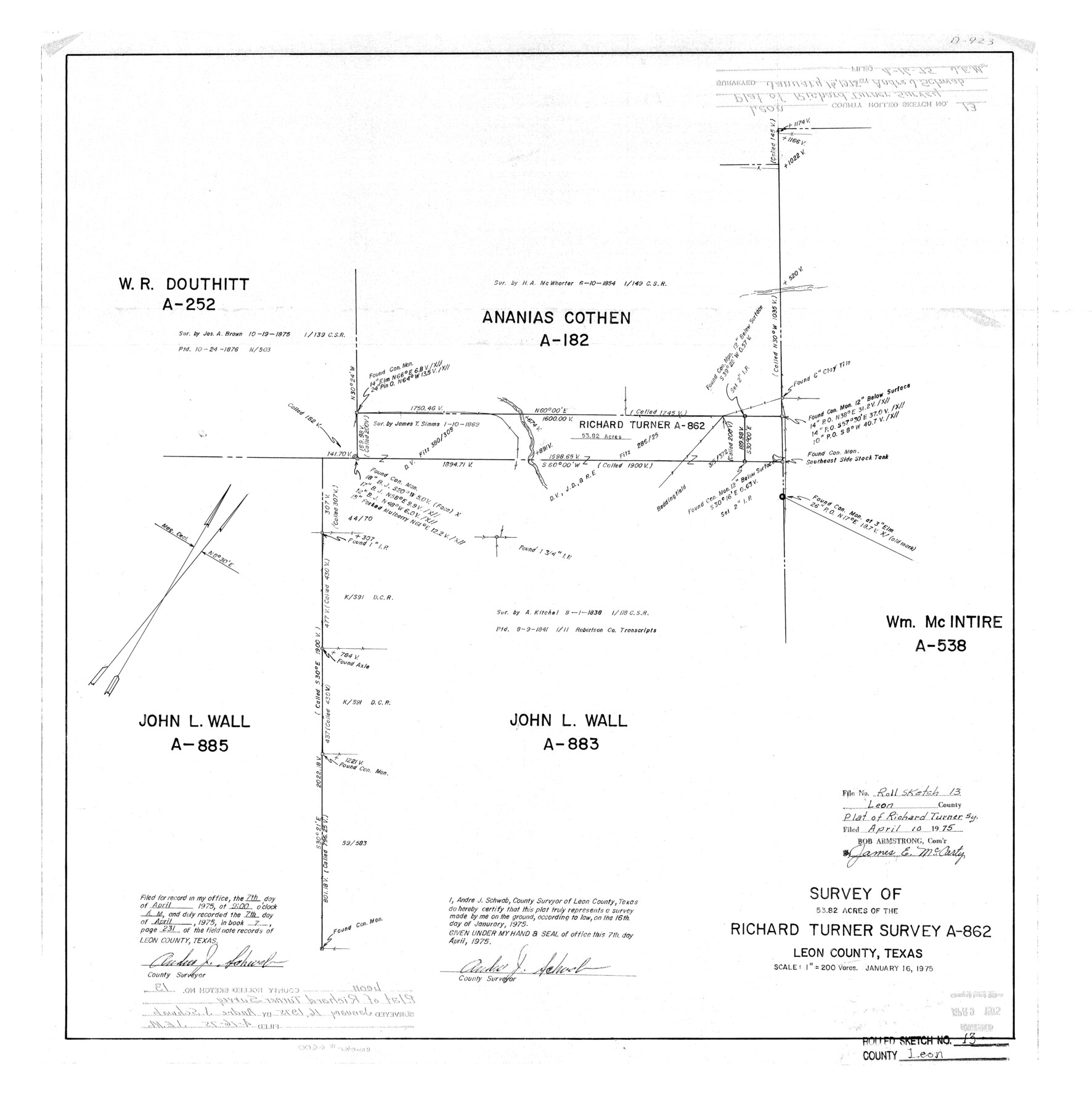
Leon County Rolled Sketch 13
Survey of 53.82 acres of the Richard Turner survey A-862, Leon County, Texas
-
Map/Doc
6600
-
Collection
General Map Collection
-
Object Dates
1975/1/16 (Survey Date)
1975/4/10 (File Date)
1975/4/7 (Creation Date)
-
People and Organizations
Andre J. Schwab (Surveyor/Engineer)
-
Counties
Leon
-
Subjects
Surveying Rolled Sketch
-
Height x Width
22.8 x 22.5 inches
57.9 x 57.2 cm
-
Scale
1" = 200 varas
Part of: General Map Collection
Wichita County Rolled Sketch 18

Print $20.00
- Digital $50.00
Wichita County Rolled Sketch 18
1924
Size 30.0 x 40.5 inches
Map/Doc 8253
Kimble County Working Sketch 64

Print $20.00
- Digital $50.00
Kimble County Working Sketch 64
1964
Size 15.1 x 16.9 inches
Map/Doc 70132
Fractional Township No. 7 South Range No. 1 West of the Indian Meridian, Indian Territory

Print $20.00
- Digital $50.00
Fractional Township No. 7 South Range No. 1 West of the Indian Meridian, Indian Territory
1898
Size 19.2 x 24.4 inches
Map/Doc 75197

Hutchinson County Rolled Sketch 40

Print $20.00
- Digital $50.00
Hutchinson County Rolled Sketch 40
1981
Size 26.1 x 37.5 inches
Map/Doc 6298
Scurry County Sketch File 3

Print $20.00
- Digital $50.00
Scurry County Sketch File 3
Size 22.0 x 24.2 inches
Map/Doc 12312
Dimmit County Sketch File 43

Print $20.00
- Digital $50.00
Dimmit County Sketch File 43
1905
Size 22.1 x 19.2 inches
Map/Doc 11353
Louisiana and Texas Intracoastal Waterway

Print $20.00
- Digital $50.00
Louisiana and Texas Intracoastal Waterway
1929
Size 13.6 x 19.8 inches
Map/Doc 83345
Victoria County Rolled Sketch 2

Print $40.00
- Digital $50.00
Victoria County Rolled Sketch 2
1940
Size 61.1 x 18.5 inches
Map/Doc 10093
Hopkins County Boundary File 3b

Print $4.00
- Digital $50.00
Hopkins County Boundary File 3b
Size 12.7 x 8.3 inches
Map/Doc 55084
Throckmorton County Working Sketch 2

Print $20.00
- Digital $50.00
Throckmorton County Working Sketch 2
1919
Size 20.9 x 16.9 inches
Map/Doc 62111
Webb County Sketch File C

Print $10.00
- Digital $50.00
Webb County Sketch File C
1915
Size 14.4 x 8.8 inches
Map/Doc 39668
You may also like
Flight Mission No. CLL-1N, Frame 87, Willacy County

Print $20.00
- Digital $50.00
Flight Mission No. CLL-1N, Frame 87, Willacy County
1954
Size 18.3 x 22.0 inches
Map/Doc 87033
Flight Mission No. DCL-4C, Frame 70, Kenedy County

Print $20.00
- Digital $50.00
Flight Mission No. DCL-4C, Frame 70, Kenedy County
1943
Size 18.7 x 22.4 inches
Map/Doc 85815
Kaufman County Sketch File 8

Print $4.00
- Digital $50.00
Kaufman County Sketch File 8
1851
Size 13.3 x 9.2 inches
Map/Doc 28638
Colton's United States shewing the military stations, forts, &c

Print $20.00
Colton's United States shewing the military stations, forts, &c
1861
Size 14.6 x 17.3 inches
Map/Doc 93565
Fannin County Boundary File 8

Print $8.00
- Digital $50.00
Fannin County Boundary File 8
Size 12.8 x 8.1 inches
Map/Doc 53316

Webb County Working Sketch 37

Print $20.00
- Digital $50.00
Webb County Working Sketch 37
1940
Size 25.0 x 20.4 inches
Map/Doc 72402
Stephens County Sketch File 26

Print $10.00
- Digital $50.00
Stephens County Sketch File 26
Size 14.1 x 8.8 inches
Map/Doc 37096
Harris County Rolled Sketch WB

Print $20.00
- Digital $50.00
Harris County Rolled Sketch WB
1916
Size 15.5 x 21.1 inches
Map/Doc 6147
Fannin County Rolled Sketch 18B

Print $20.00
- Digital $50.00
Fannin County Rolled Sketch 18B
Size 12.7 x 16.1 inches
Map/Doc 5869

United States - Gulf Coast Texas - Southern part of Laguna Madre

Print $20.00
- Digital $50.00
United States - Gulf Coast Texas - Southern part of Laguna Madre
1941
Size 26.4 x 18.2 inches
Map/Doc 72945