Cameron County Rolled Sketch US1
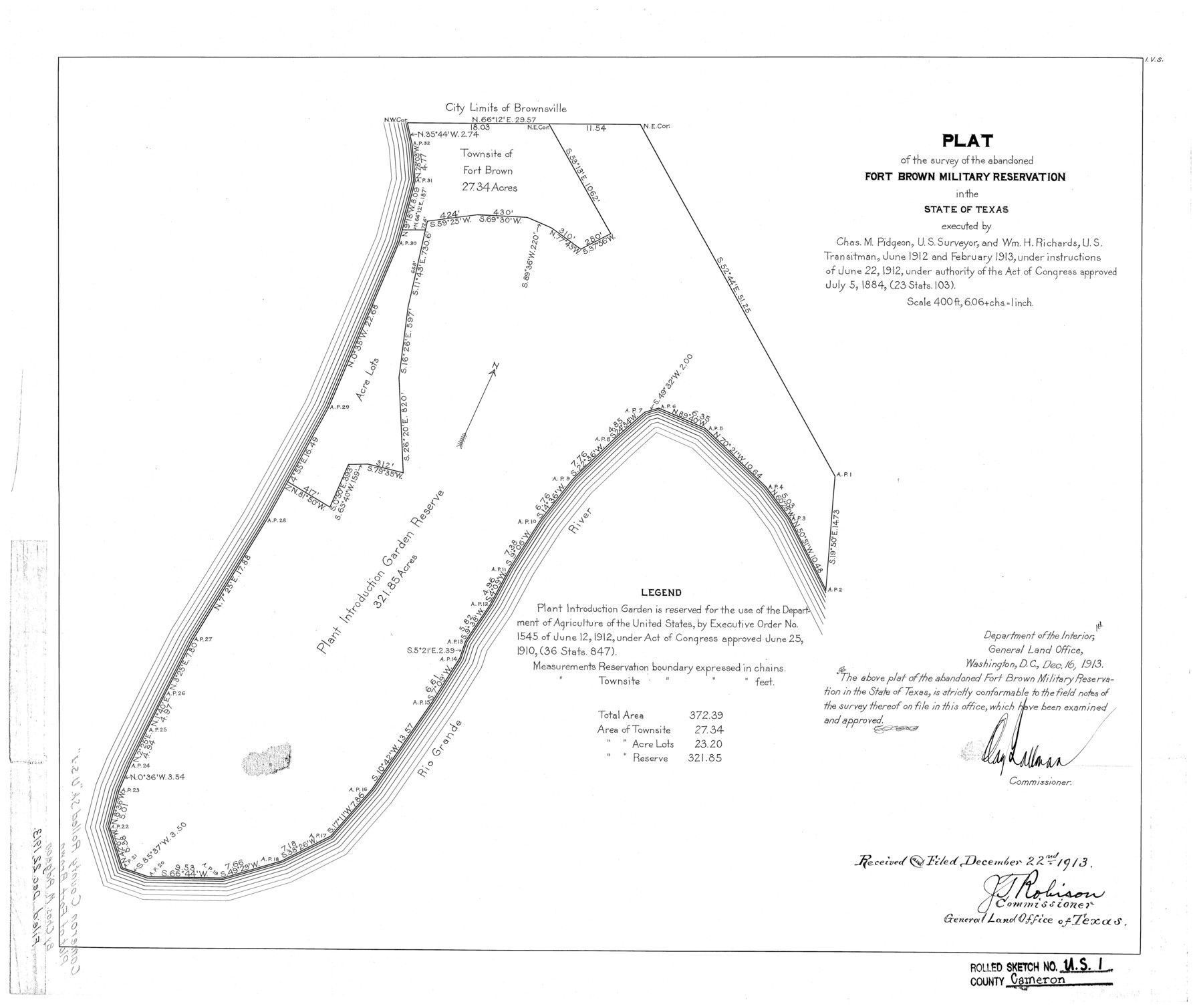
Plat of the survey of the abandoned Fort Brown Military Reservation in the State of Texas
-
Map/Doc
5399
-
Collection
General Map Collection
-
Object Dates
1913 (Creation Date)
1913/12/22 (File Date)
-
People and Organizations
Chas. M. Pidgeon (Surveyor/Engineer)
Wm. H. Richards (Chainman/Field Personnel)
-
Counties
Cameron
-
Subjects
Surveying Rolled Sketch
-
Height x Width
21.2 x 25.3 inches
53.8 x 64.3 cm
-
Comments
See Cameron County Rolled Sketch US (5398) for related sketch and Cameron County Rolled Sketch US2 (43804) for field notes.
Related maps
Cameron County Rolled Sketch US2

Print $168.00
- Digital $50.00
Cameron County Rolled Sketch US2
1913
Size 10.4 x 16.3 inches
Map/Doc 43804
Cameron County Rolled Sketch US

Print $20.00
- Digital $50.00
Cameron County Rolled Sketch US
1913
Size 31.1 x 26.3 inches
Map/Doc 5398
Part of: General Map Collection
Falls County Sketch File 5

Print $9.00
- Digital $50.00
Falls County Sketch File 5
1857
Size 12.5 x 8.7 inches
Map/Doc 22337

Val Verde County Working Sketch 91

Print $20.00
- Digital $50.00
Val Verde County Working Sketch 91
1976
Size 46.5 x 42.8 inches
Map/Doc 72226
Mills County Working Sketch Graphic Index

Print $20.00
- Digital $50.00
Mills County Working Sketch Graphic Index
1976
Size 35.6 x 45.1 inches
Map/Doc 76643
Gulf Intracoastal Waterway - Aransas Bay to Corpus Christi Bay - Modified Route Main Channel

Print $20.00
- Digital $50.00
Gulf Intracoastal Waterway - Aransas Bay to Corpus Christi Bay - Modified Route Main Channel
1960
Size 30.9 x 42.8 inches
Map/Doc 61900
The Cotton Kingdom: a Traveller's Observations on Cotton and Slavery in the American Slave States

The Cotton Kingdom: a Traveller's Observations on Cotton and Slavery in the American Slave States
Map/Doc 96571
Edwards County Sketch File 40

Print $20.00
- Digital $50.00
Edwards County Sketch File 40
1940
Size 20.4 x 14.3 inches
Map/Doc 11438
Carta de las provincias de Tejas Nuevo Santander, Nuevo Reino de Leon y Nueva Estremadura

Print $20.00
- Digital $50.00
Carta de las provincias de Tejas Nuevo Santander, Nuevo Reino de Leon y Nueva Estremadura
1773
Size 21.5 x 26.6 inches
Map/Doc 3031
Shelby County Sketch File 29

Print $4.00
- Digital $50.00
Shelby County Sketch File 29
Size 8.1 x 12.8 inches
Map/Doc 36666
Crockett County Sketch File 35d

Print $10.00
- Digital $50.00
Crockett County Sketch File 35d
Size 14.2 x 8.9 inches
Map/Doc 19750
Amistad International Reservoir on Rio Grande 90

Print $20.00
- Digital $50.00
Amistad International Reservoir on Rio Grande 90
1950
Size 28.5 x 39.7 inches
Map/Doc 75520
Lipscomb County Working Sketch 4

Print $40.00
- Digital $50.00
Lipscomb County Working Sketch 4
1974
Size 51.7 x 43.8 inches
Map/Doc 70580
You may also like
Jackson County NRC Article 33.136 Sketch 1

Print $66.00
- Digital $50.00
Jackson County NRC Article 33.136 Sketch 1
2013
Size 34.0 x 22.0 inches
Map/Doc 94950

The Republic County of Matagorda. January 19, 1841

Print $20.00
The Republic County of Matagorda. January 19, 1841
2020
Size 21.0 x 21.7 inches
Map/Doc 96220
Map of Fort Worth

Print $40.00
- Digital $50.00
Map of Fort Worth
1902
Size 61.3 x 34.8 inches
Map/Doc 93274
Jeff Davis County Sketch File 42

Print $20.00
- Digital $50.00
Jeff Davis County Sketch File 42
Size 21.8 x 27.9 inches
Map/Doc 11867
Borden County Rolled Sketch 11

Print $20.00
- Digital $50.00
Borden County Rolled Sketch 11
1963
Size 33.2 x 32.2 inches
Map/Doc 8450
Hartley County Sketch File 6

Print $20.00
- Digital $50.00
Hartley County Sketch File 6
Size 30.5 x 25.6 inches
Map/Doc 11698
Hamilton County Sketch File 14

Print $10.00
- Digital $50.00
Hamilton County Sketch File 14
Size 10.1 x 8.0 inches
Map/Doc 24937
Young County Sketch File 6

Print $14.00
- Digital $50.00
Young County Sketch File 6
Size 13.0 x 8.2 inches
Map/Doc 40852
Tom Green County Rolled Sketch 3

Print $20.00
- Digital $50.00
Tom Green County Rolled Sketch 3
Size 26.8 x 32.8 inches
Map/Doc 7993
Hall County Working Sketch 10

Print $20.00
- Digital $50.00
Hall County Working Sketch 10
1983
Size 34.3 x 42.9 inches
Map/Doc 63338
Jackson County

Print $20.00
- Digital $50.00
Jackson County
1920
Size 46.9 x 40.8 inches
Map/Doc 77324