Mason County Rolled Sketch 1
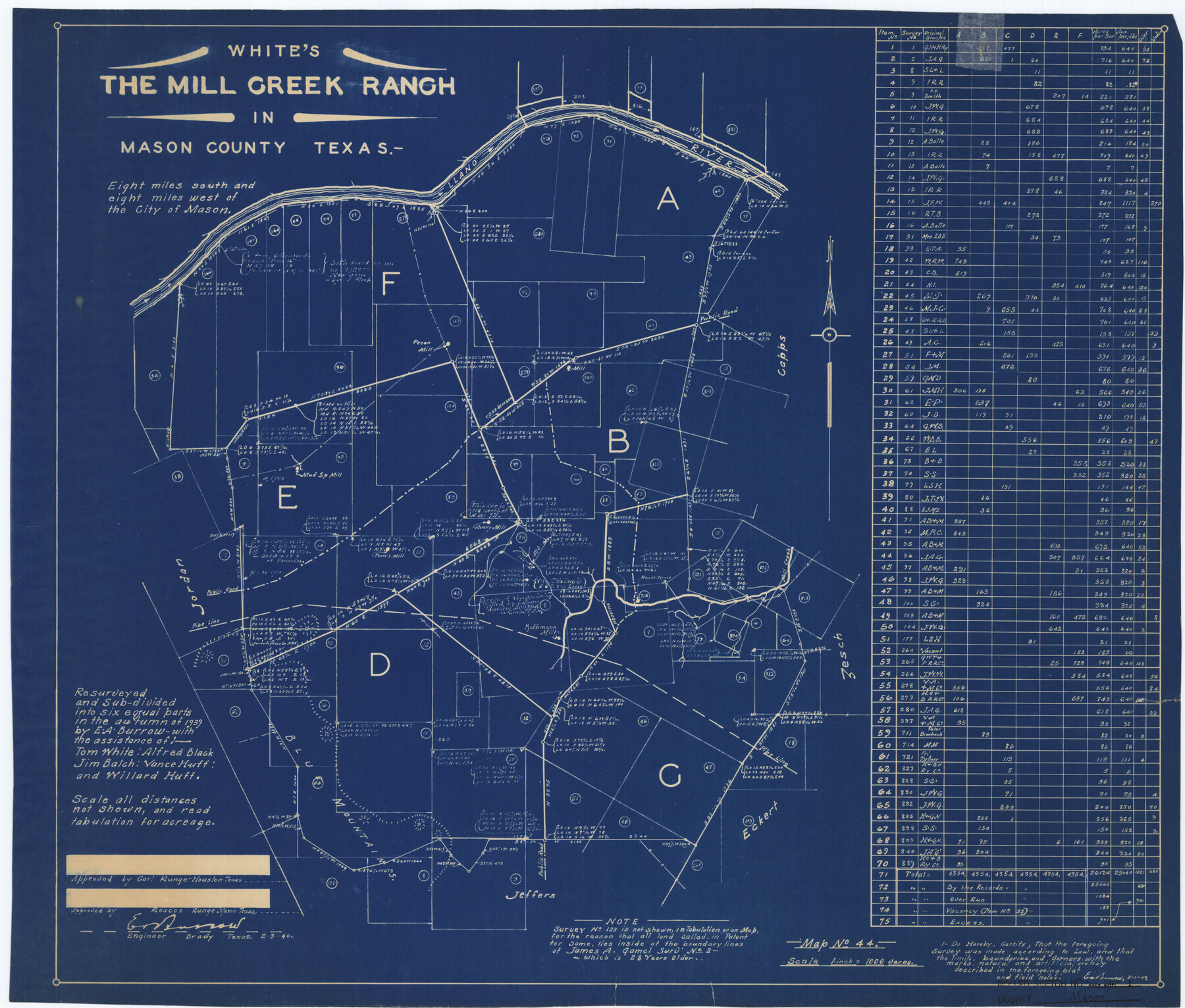
White's the Mill Creek Ranch in Mason County, Texas
-
Map/Doc
6674
-
Collection
General Map Collection
-
Object Dates
1940/2/1 (Creation Date)
-
People and Organizations
E.A. Burrow (Surveyor/Engineer)
-
Counties
Mason
-
Subjects
Surveying Rolled Sketch
-
Height x Width
21.2 x 24.9 inches
53.8 x 63.2 cm
-
Medium
blueprint/diazo
-
Scale
1" = 1000 varas
Part of: General Map Collection
Hale County Sketch File 26

Print $40.00
- Digital $50.00
Hale County Sketch File 26
1911
Size 20.7 x 54.4 inches
Map/Doc 10471
Gray County Working Sketch 5

Print $20.00
- Digital $50.00
Gray County Working Sketch 5
1959
Size 28.6 x 27.5 inches
Map/Doc 63236
Bosque County Working Sketch 13

Print $20.00
- Digital $50.00
Bosque County Working Sketch 13
1957
Size 17.2 x 14.5 inches
Map/Doc 67446
[Surveys along the San Antonio Road near Caldwell]
![69760, [Surveys along the San Antonio Road near Caldwell], General Map Collection](https://historictexasmaps.com/wmedia_w700/maps/69760.tif.jpg)
Print $2.00
- Digital $50.00
[Surveys along the San Antonio Road near Caldwell]
1846
Size 9.2 x 7.7 inches
Map/Doc 69760
Shelby County Shelby District

Print $20.00
- Digital $50.00
Shelby County Shelby District
1880
Size 20.5 x 25.3 inches
Map/Doc 4030
Mitchell County

Print $20.00
- Digital $50.00
Mitchell County
1971
Size 43.6 x 37.0 inches
Map/Doc 95592
Flight Mission No. DQN-1K, Frame 146, Calhoun County

Print $20.00
- Digital $50.00
Flight Mission No. DQN-1K, Frame 146, Calhoun County
1953
Size 18.7 x 22.3 inches
Map/Doc 84209
Brown County Sketch File 28

Print $4.00
- Digital $50.00
Brown County Sketch File 28
1875
Size 11.6 x 8.3 inches
Map/Doc 16626
Presidio County Rolled Sketch 93

Print $20.00
- Digital $50.00
Presidio County Rolled Sketch 93
Size 35.5 x 31.1 inches
Map/Doc 7378
Flight Mission No. CUG-1P, Frame 161, Kleberg County

Print $20.00
- Digital $50.00
Flight Mission No. CUG-1P, Frame 161, Kleberg County
1956
Size 18.5 x 22.3 inches
Map/Doc 86168
Wheeler County Sketch File 2

Print $26.00
- Digital $50.00
Wheeler County Sketch File 2
1881
Size 19.0 x 7.9 inches
Map/Doc 39994
Crockett County Working Sketch 15

Print $20.00
- Digital $50.00
Crockett County Working Sketch 15
1916
Size 16.2 x 20.4 inches
Map/Doc 68348
You may also like
Flight Mission No. DCL-5C, Frame 4, Kenedy County

Print $20.00
- Digital $50.00
Flight Mission No. DCL-5C, Frame 4, Kenedy County
1943
Size 18.6 x 22.5 inches
Map/Doc 85829
Comal County Rolled Sketch 1

Print $20.00
- Digital $50.00
Comal County Rolled Sketch 1
1972
Size 24.2 x 19.6 inches
Map/Doc 5535
Dimmit County Sketch File 23

Print $38.00
- Digital $50.00
Dimmit County Sketch File 23
1894
Size 10.0 x 11.8 inches
Map/Doc 21133
Bexar County Working Sketch 9

Print $20.00
- Digital $50.00
Bexar County Working Sketch 9
1956
Size 23.4 x 21.6 inches
Map/Doc 67325

Flight Mission No. DCL-6C, Frame 8, Kenedy County

Print $20.00
- Digital $50.00
Flight Mission No. DCL-6C, Frame 8, Kenedy County
1943
Size 18.5 x 22.5 inches
Map/Doc 85868
Presidio County Working Sketch 84

Print $20.00
- Digital $50.00
Presidio County Working Sketch 84
1970
Size 20.7 x 17.8 inches
Map/Doc 71761
Calhoun County Rolled Sketch 3

Print $20.00
- Digital $50.00
Calhoun County Rolled Sketch 3
Size 28.0 x 21.9 inches
Map/Doc 5361
Carson County Boundary File 5c

Print $10.00
- Digital $50.00
Carson County Boundary File 5c
Size 14.2 x 8.7 inches
Map/Doc 51146
Angelina County Working Sketch 13

Print $20.00
- Digital $50.00
Angelina County Working Sketch 13
1935
Size 30.8 x 35.4 inches
Map/Doc 67094
Medina County Rolled Sketch 7

Print $20.00
- Digital $50.00
Medina County Rolled Sketch 7
1966
Size 36.9 x 21.9 inches
Map/Doc 6741
Montague County Working Sketch 26

Print $20.00
- Digital $50.00
Montague County Working Sketch 26
1956
Size 23.5 x 23.2 inches
Map/Doc 71092